A handheld GPS fits the needs of most daysailors, racers, and weekend cruisers, and at less cost than a fixed chartplotter. With updated charts, even basic handhelds provide the necessary information. For most cruisers and bluewater sailors, a handheld is good to have as a backup to the primary chartplotter or for emergency use in a life raft.
One of the newest additions to the handheld electronics market is the Earthmate PN-40 GPS by DeLorme, a Maine-based manufacturer of mapping products and technologies for the consumer and professional markets. Practical Sailor testers recently put the gadget through its paces, comparing it to our reigning handheld Best Choice,
288
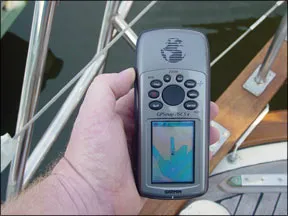
the Garmin GPSMap 76CSx.
West Marine’s rebranded version of the GPSMap 76CSx bested eight other handhelds in our November 2006 test for the top spot, but that model has since been discontinued. We pitted Garmin’s GPSMap 76CSx, which is still available, against the company’s newest handhelds—the Colorado 400C and the Oregon 400C—in the December 2008 issue. Although it lacked some of the advanced features of the newer models, testers preferred the older Garmin GPSMap 76CSx, which is an excellent performer and has memory-expansion capability that puts it on par with newer handhelds.
How We Tested
The DeLorme was evaluated using the same test and criteria that we have used in past handheld GPS tests. Testers used the units for multiple days and rated key functions (saving waypoints and plotting routes), and a battery test was performed with the backlighting on, but set to the lowest setting.
The waterproofness evaluation mimicked the IPX7 standard test, which requires that the product survive being submerged for 30 minutes in three feet of water. The unit was also dropped three feet onto a fiberglass surface on each side. “Cold starts” in multiple locations were performed to compare the time needed to get a satellite fix.
Screen visibility was compared on the water in sunlight and at night while viewing the display from straight on and the sides. Daylight visibility tests were carried out with and without polarized sunglasses.
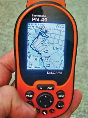
DeLorme Earthmate
The DeLorme Earthmate PN-40 is an upgraded version of the PN-20. It uses a dual-core processor to speed up screen re-draws when panning the chart display and has 1 gigabyte internal memory with 500 megabytes available for user storage.
The PN-40 is a bit chunky but fits nicely in one hand or a pocket and packs a lot of functions into its rubberized case with standard button controls. The PN-40 meets IPX7 waterproof standards and is submersible to one meter for 30 minutes; its screw-down fasteners on the battery cover and flush-mounted pad for the USB interface cable help keep water from seeping into the case.
Features: An electronic compass provides heading information when the unit is not moving and performs in any position. Unfortunately, Practical Sailor testers were not able to get
288
the electronic compass to supply correct heading information when the test unit was stationary. This could have been due to a fault in this particular unit or operator error. Underway, the GPS is used to provide heading information. Both require user calibration.
A built-in tidal database supplies the user with graphic and tabular tidal information for points near the unit’s current position and is not limited to tidal reporting stations. The database appears to have the time and height differences for many other locations stored as well.
A single button press activates an excellent find function that provides the location of an impressive number of points of interest near the user’s position. Marinas, airports, restaurants, and more are displayed for ease of location.
The unit also offers barometric pressure and altitude readings.
Display: The 2.2-inch, high-resolution TFT display is easily readable in bright sunlight but loses a bit in the shade, although it’s still quite readable. Indoors, backlighting makes the display usable, even in very low light conditions.
The display is smaller than testers prefer for marine use, even for a handheld. Panning or moving the map only takes place when the cursor is moved to the edge of the display. This is a bit awkward and time-consuming, in our opinion, as it requires that the cursor be moved back to the other side of the display to pan in the opposite direction. As the chart is panned with the cursor, newly exposed chart areas are blank until panning is complete. This makes it difficult to pan for any distance because the entire map goes blank. The text displayed on the menus, data fields, and base map is quite small and may be difficult to read in a seaway. NOAA raster charts are easy to read but as you would expect, only small areas of the NOAA chart can be displayed on the screen.
Battery life: According to DeLorme, the PN-40 requires about 600 microwatts to operate without backlighting or a Secure Digital (SD) memory card. The power-saver function reduces it to 350 microwatts, but the performance sacrifice is not known.
Using two fresh Energizer AA alkaline batteries (in series, producing 3 volts), which have an average capacity of 2.87 watt/hours, the PN-40 ran for 7 hours, 6 minutes before giving a low-battery warning and another 32 minutes before total shutdown. The test was done after minimal backlight use (less than 2 minutes), and the memory card was installed. Optional lithium (Li-ion) rechargeable batteries are
288
available for the PN-40 and are recharged via the USB cable. For onboard use without a PC, spare alkaline batteries or a standalone charger for rechargeable batteries might be needed for prolonged use.
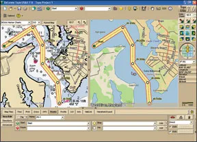
Charts and charting software: The PN-40 comes with Topo USA, PC software on a DVD that is used to access the online map library and to create waypoints and routes. Maps/charts are loaded by exporting them from the Topo USA software to the PN-40 when connected via the USB cable. Routes and waypoints can also be transferred this way.
The Topo USA software provides a dual image look at the maps and charts. If the GPS is connected to the PC, Topo could likely serve as onboard charting software but it is somewhat limited in this role.
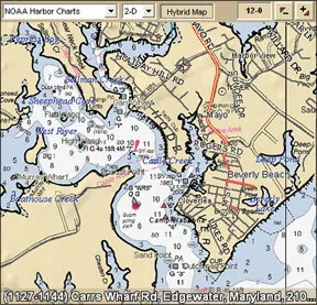
NOAA marine raster charts (RNCs) can be used with the PN-40 but only when downloaded from the DeLorme online library and exported to the device, using the Topo USA software and a PC with Internet access. NOAA marine raster charts cost $10 each; NOAA charts downloaded from the government website cannot be used.
A $30 annual subscription to the online map library gives the user unlimited access to the library, which contains a full set of NOAA RNCs plus color aerial images, topographic maps, and city maps that can be used with the PN-40. For most, a subscription would be the best choice from a financial standpoint.
Testers did have a few issues with the Topo USA software. The PN-40 is supplied with a 1-gigabyte Secure Digital (SD) memory card and also can be used with Secure Digital High Capacity (SDHC) cards, which are available with as much as 32 gigabytes of storage. The assumption is that charts for a particular trip will be exported from the library to the PN-40 as needed. It is possible to store all the necessary NOAA charts on the PN-40 with a large memory card installed, but these must be exported from a PC using the Topo USA software. For a short trip, this process works well, but for longer, multi-day trips, it takes awhile to accomplish.
Topo USA software has the rather unique ability to create hybrid charts using information from other map formats overlaid on the NOAA raster chart. When the NOAA chart is exported to the PN-40, the data layer can be included, allowing the PN-40 to display hybrid charts as well.
Testers found Topo USA to be very much land oriented, not at all intuitive, and somewhat laborious to use, particularly for planning a marine route.
It seems that NOAA charts can only be displayed in the left-hand window but that routes must be laid out in the right-hand window where the land-based map is shown. Fortunately, a dual cursor display allows users to see the position on the NOAA chart as they click on the land-based map when laying down a route. Waypoints must be designated as “start,” “stop,” “via,” or “finish” by clicking on the appropriate button before placing them on the chart.
Testers found editing the route equally arduous: The user must choose from a series of buttons, select the waypoint to be moved, and designate whether the waypoint is inserted or added.
Once testers did this process a few times, it seemed faster and less difficult, but it still failed to compete with typical marine charting software for ease of use. Before a route can be planned, you must choose the mode: “direct,” “trail,” or “road.” Direct is the only choice for marine routes, but testers had problems when inserting the first waypoint, which sometimes appeared on a road, regardless of where they attempted to place it on the chart.
GPS performance: The PN-40 uses a Cartesio GPS Chipset from STMicroelectronics. It’s quite fast and performs well even when a full view of the sky isn’t available. During testing, it would start and run indoors with no difficulty. The PN-40 should easily function in virtually any of the challenging environments that it might encounter.
If the unit is not on the status page, the only visible warning that the GPS does not have valid position is a red flashing position triangle on the map or chart at the
288
last position. Latitude and longitude information is still shown, but it is based on the cursor position or map center.
PN-40 functionality: The PN-40’s controls are well placed and easy to use, and it is user-configurable in almost every area. A page button is used to cycle through the various functions and features, but the choice of pages to be displayed can be selected from a setup list. Information displayed on many pages can be configured as desired, and a menu button provides access to choices for the current page or provides access to the main setup area.
There is no tracking or follow mode selection, but if a GPS position is available, the PN-40 will automatically follow it across the map/chart, updating the display as needed. If the map is panned away from the GPS position with the cursor controls, it will continue to display this area until the user leaves the map page. When the page is next accessed, the map will be centered on the GPS position.
Routes can be entered directly on the map/chart display by moving the cursor and selecting the current location with the enter key. Unfortunately, routes and waypoint positions can only be edited by changing the waypoint lat/long coordinates, although waypoints can be deleted entirely, if desired.
A coordinate’s content is changed by arrow keys, but a keyboard display is provided to enter text when needed.
While testers found this palm-sized GPS to be rugged and a good performer, they did find a few drawbacks like the display blanking while panning and that the NOAA chart can only be displayed when zoomed in beyond a certain level. Otherwise, the underlying land-based map is always shown.
There is no steering display for use when tracking to a waypoint. The user can derive this information using a combination of heading versus bearing to the waypoint and cross track error.
The charger-USB connection is always exposed, and it’s possible that shorting them together with metallic objects such as coins could damage the device’s circuitry. According to DeLorme, there have been no reported instances of this happening. However, we would prefer a simple snap-in cover for the port as a preventive measure.
Bottom Line
The DeLorme PN-40 is a rugged, well-constructed device, loaded with useful features, but it is somewhat limited from a marine standpoint.
It is a good tool for trips ashore, and it will still offer some functionality aboard. The tidal display and “find” features and the 3D topographical maps make it a versatile tool for multisport users, but for those looking for a handheld GPS for marine use, there are better, less expensive choices out there, including the Garmin GPSMap 76CSx, which remains our Best Choice in this test field.