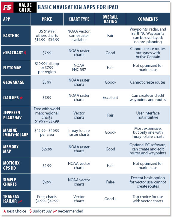
This article is part deux in Practical Sailors three-part series on navigation apps for the iPad. Although many of these applications also can be used with an iPhone, Android, or similar device, weve limited testing to an iPad platform as it offers a screen large enough to rival some dedicated chartplotters.
We launched the series in the February 2012 issue with a look at three of the most popular-and more expensive-full-feature nav apps available for iPads: iNavX, Navionics, and Navimatics. This months article delves into the less expensive-free in some cases-and more basic navigation apps. Part 3 will cover the various apps that are applicable for sailors, like weather-, tides-, and radar-related apps.
While suitable apps enable the iPad to function much like a regular chartplotter-some even allow weather overlays and can be networked to boat instruments via a WiFi connection-we don’t recommend using an iPad and the apps weve reviewed as your sole navigating tools. For most cruisers, the iPad and apps will serve best as auxiliary or backup nav electronics. Of course, we still recommend keeping a library of paper charts onboard as well: Never depend on a single source for navigational info.
How We Tested
In Apples catalog of more than 300,000 apps, we found more than a dozen that will convert your iPad into a chartplotter. The best operate like dedicated chartplotters; a couple work like simpler plotters, often with some functions that people might like, at a lower price.
PS tested them all during three seasons of cruising the Great Lakes and Florida. Testers used each one to carry out a series of normal navigation tasks (downloading charts, entering a waypoint, creating a route, opening new charts, zooming the charts, and creating a track of our movement). On all the apps we recommend, these functions work well, but differently. Testers also evaluated add-on features like satellite-image overlay or points-of-interest information.
Most of the nav apps are works-in-progress, and users can expect continued updates in all the apps.
But one of the primary reasons for choosing one app over another will likely be related to the type of charts used: raster versus vector charts. Raster charts are basically like scanned images of paper charts with metadata added so that nav software can report lat/lon coordinates and other chart information such as depth and measurement units, as well as calculating bearings and distances.
Vector charts, however, are layered with types of information grouped together, following an international protocol (S-57)-depths in one layer, bottom characteristics in another layer, other navigational objects in another. The nav software/app can customize how these layers are displayed. Most of the layers are provided by NOAA, but proprietary companies like Navionics, C-Chart, and Garmin can add information layers, such as marina information, photographs, and so on.
Those who like and are used to paper charts will prefer the raster charts. Those more adapted to Navionics and Garmin software may prefer the vector charts.
Vector charts are seamlessly quilted together so that you can drag, zoom, and pan large distances without having to close one chart and open another. On a raster chart, when youre moving and get to the edge of one chart, a new chart has to open (the software does this automatically in our recommended apps). However, when planning (not navigating), you have to open the charts individually.
EarthNC Marine Charts
Made by Wavey Line Publishing, EarthNCs Marine Charts range from $14.99 for Brazil or New Zealand raster charts to $19.99 for U.S. charts and $34.99 for Bahamas raster charts. Cheaper than iNavX or Navionics software we reviewed in the first part of this series, EarthNCs Marine Charts is a good basic chartplotting app, but it does have its problems.
One notable shortcoming is that the help guide is not built into the app, so you must have an Internet connection to access it. Also, all of the examples and screenshots in the help guide are for the apps iPhone version, which has slightly different icons, labels, and features. Users wind up with some unexplainable things happening.
This app uses primarily NOAA vector charts, but you can also buy raster-chart versions for the Bahamas, Brazil, and New Zealand. The software will update the charts weekly. The app also comes with three base maps: Google satellite, My Topo USGS, and CloudMade Road maps. Unlike the Navionics app, these additional maps don’t overlay charts but replace them on the screen if you select them. Theyre not much use for navigating, though its fun to occasionally switch to the Google satellite views while underway.
Info that can be overlaid on charts include user waypoints, NexRad radar, and EarthNC Waypoints (which appear to be the same NOAA points of interest such as lights and nav-aids that appear on other vector programs, plus other information that comes from CruisersNet.net, Waterway Guide, and Marina Life cruising app, a listing of some marina facilities). The extra non-NOAA info is spotty: Although there is plenty along the Florida east coast, for example, a lot of info is missing for the Great Lakes.
The NexRad radar sounds like a good idea, but when you activate it, some fuzzy green blobs appear on the chart-they are hard to interpret and seem pretty useless, compared to the radar views that you get in good weather apps-plus you need an Internet connection to get the radar data.
EarthNCs NOAA/CruisersNet/MarinaLife features suffer from a problem inherent in vector charts. As you zoom, different layers of information become available; the trouble is that its never clear what level of zoom is needed to have the EarthNC features appear. And frequently, such a cluster of waypoints shows up that it becomes impossible to read them or to find spots youre looking for. You can turn the layer off, of course, but then you can’t see the info or go-to waypoint.
The apps points of interest are recalled from the Internet-not stored in memory-so if you don’t have a live connection, you can’t use them.
The screen layout is fairly good. There are four straightforward icons on the upper right of the screen. The waypoints usage is probably the weakest point of this app. You can drop a pin in the center of the map or near your GPS location. The pin will start in edit mode, so that you can name it, drag it around on the chart, add descriptions, etc. But once you save the waypoint, theres no way to move or otherwise edit it.
Another drawback is that there is no way to create a route ahead of time, although weve heard that they will be adding this capability. For now, you can activate tracking and record a track while underway, and then e-mail it to the company website from whence you download it or send it to someone else as a GPX file. You can open any waypoint and click on guide me, and the app will create a straight-line go-to to that waypoint, but you can’t do more than one waypoint at a time for a route.
At the bottom of the screen are five icons, indicating map, trip, POIs, saved, and settings. (Again, the help section describes the slightly different iPhone icons, so weve created a couple of these names.) These are pretty straightforward, as well, though the detail when youre recording a trip seems excessive, including such things as pace (minutes per nautical mile) in addition to moving speed, max speed, current speed, moving time, stopped time, and a page-wide graph showing speed variation over time. All of this info may be useful to some sailors, but it was overkill for our testers purposes.
Bottom line: Overall, the app has some notable shortcomings. Since its $20 to $30 less than the better iNavX and Navionics apps, it might be worth considering for the budget-strapped. But one of our principal uses of chartplotter software is route planning ahead of time. Since this app doesn’t have it, we wouldnt buy it.
(Editors Note: One odd thing we noticed was that the iTunes store warns users that this app has infrequent mature/mild suggestive/ themes. We hunted hard but couldnt find them.)
eSeaChart
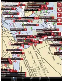
We used Sailport ABs eSeaChart app last summer on a short cruise. (See Inside Practical Sailor, July 6, 2011.) As you might expect for $7.99, its a minimalist chartplotter. Its chief appeal for many will be the inclusion of Active Captain information, which will pop up on the screen when you click an icon (marina, anchorage, inlet, etc.) on the chart.
Active Captain is a cruising-information website that offers info supplied by cruisers who register for the site and become Captains. It is sort of a Wikipedia for cruising sailors-get input from enough cruisers and you can sort out the bad info. So far, the coverage is spotty, and most of the information appears unedited, so youll want to use it with caution. But the database is growing-website creator Jeffrey Siegel told us Active Captain currently gets about 2,000 updates every day-and many cruisers seem to like it. Its even incorporated into high-end computer (not iPad) charting software, like Coastal Explorer, Max Sea, and Nobeltec,
The eSeaChart app is the lowest priced way to get the Active Captain info on the iPad, since it is incorporated in the plotting software, creating a database of the information and inserting icons on the free NOAA raster charts. The Active Captain database can be updated whenever youre connected to the Internet.
As youd expect at this low price, eSeaChart offers minimalist plotting functions. It uses the free NOAA raster charts (with Active Captain markers imposed on them).
Unlike the pricier apps, the charts don’t seem to self load, even though the developer has a YouTube.com video showing the charts self-loading. Instead, when your position moves to the edge of one chart, users have to manually load the next.
Users can create a waypoint and sail to it; however, you cannot create a route or save a track. The moving-map display shows your position, along with course and speed, but thats about it.
Bottom line: This is among the better inexpensive apps. Its worth considering as a backup chartplotting app, but iSailGPS (see below) is a better low-price alternative, if you can do without the Active Captain data. If you really must have the Active Captain database on your iPads nav software, look at Charts & Tides by Navimatics (PS, February 2012), which is a better nav app, though more than twice the price.
FlyToMap GPS HD
FlyToMap advertises its app as a multi-use navigating program, using park maps, water maps, lake maps, and travel maps. Promoted as a combo iPhone, iTouch, and iPad app, the basic FlyToMap GPS HD costs $19.99, or you can buy the app for dozens of specific geographic locations (e.g. Chesapeake Bay, Louisiana-Mississippi, Scotland, Sydney, Oslo, etc.) for $7.99 each.
It works, but it is not optimized for maritime use-or for iPad use as the display seems to have been designed for the tiny screen of the iPhone.
Bottom line: Priced at the high end of the apps were reviewing this month, FlyToMap ranks at the bottom of our choices for an on-board navigation app.
GeoGarage Marine US
The GeoGarage Marine US is a simple and cheap ($5.99) chartplotting app that uses raster charts. It has minimal functionality-similar to eSeaChart, but without the additional Active Captain info.
Users can create waypoints but not edit them, and users cannot create routes.
Marine Brazil and Marine New Zealand are also available for $5.99 each.
Bottom line: Spend $2 more and get eSeaChart or iSailGPS.
iSailGPS
Another basic app that uses NOAA raster charts, iSailGPS ($7.99) by James Associates has several distinct advantages over its nearest competitors, eSeaChart and Simple Charts. Users can create and edit waypoints and routes. It also has an excellent built-in help guide and more help on the developers website; testers found this to be the best combination of text and screenshots among all the low-priced apps. Potential buyers can get a good idea of how the app works from the company website, www.isailgps.com.
In use, its straightforward, but we particularly like the display and icons. Across the bottom of the screen are icons for my location, track, waypoints, routes, and chart list. Not to sound too curmudgeonly, but we prefer when marine nav programs use marine navigation terms, like chart rather than map and waypoint rather than POI. Dropping a pin, common on a number of apps, just doesn’t seem to fit on a sailboat. Its nice to think that this app was created by someone who understands sailing.
It will take a while to download all the desired charts; you have to download (or update) them one at a time. The program crashed once when we were using it, but otherwise, we couldnt find anything to object to.
Bottom line: In basic navigating functions, this is the best of the low-priced apps. If you want the additional info of Active Captain, consider eSeaChart. If you want vector charts, consider Simple Charts. Otherwise, this is the Best Choice-and the price is right.
Jeppesen Plan2Nav
The basic version of Jeppesens Plan2Nav app is free and comes with a world map. Vector charts for specific regions range from $19.99 to $37.99.
Jeppesen and its C-Charts are well known in the marine navigation world, but testers found this apps user-interface to be inexplicably unfriendly, with a bunch of tiny icons across the bottom of the screen. It took us longer to learn basic operations with this app than with the dozens of others weve reviewed. (We eventually gave up trying to name waypoints, for example.) This was too steep of a learning curve for the usually intuitive iPad apps, in our opinion.
Bottom line: The company advertises it primarily as a planning tool, but even for that preliminary work, other chartplotter apps-like those we reviewed in the February 2012 issue-work better.
Marine Imray-Iolare
The most expensive of the nav apps we looked at, the Marine Imray-Iolare rings in at $42.99 to $49.99 per area (Eastern Caribbean, Atlantic Europe, West UK and Ireland, North Sea, etc.).
The apps chartplotter function is good, but not particularly distinctive, in our opinion. The main attraction is the Imray-Iolaire charts, particularly of the Caribbean, which have been rasterized. These were historically the creation of Donald Street Jr., intended to correct what he considered the unsatisfactory British Admiralty Charts.
If you want the Imray-Iolaire charts electronically and on the iPad, the only way you can get them is by buying their apps. Theyre expensive, but what can you do?
Bottom line: If youre a die-hard Imray-Iolaire chart user, this app may be worth considering, but its jacked-up price is double that of the best nav apps we reviewed.
Memory Map
The Memory Map app is most comparable to Marine Charts by EarthNC, with basic chartplotter functions. It uses raster charts rather than the vector charts EarthNC uses, and it doesn’t have all the extra points-of-interest. On the other hand, Memory Maps handling of waypoints and routes is better. In addition, you can buy the Memory Map PC software and create and edit exportable routes and waypoints at home.
One nice feature of the app is that you can download a free version along with a few charts for a time-limited demo. If you like, you can buy additional charts. For $27.99, you get the app with all NOAA raster charts, but adding the PC software increases the package price to $50. Many other map types are also available-topos, road maps, etc.-at various prices.
We recommended Memory Maps Pocket Nav as a good, simple nav device in our review of iPhone apps (PS, April 2010). However, their iPad version retains many its characteristics, including pop-up menus that occupy the center of the screen, often obliterating the chart youre viewing. While this is probably necessary on the small-screen iPhone, its a waste of real estate on the larger iPad screen, in our opinion.
As with many iPhone-centered apps, this one seems to be designed for viewing in portrait format-as we noted earlier, you can’t view the iPad screen with polarized sunglasses unless you turn it to landscape, and the vertical design suffers.
Bottom line: Memory Map is a good nav app, but we think most sailors would be happier spending the extra $10 or $20 for iNavX or Navionics, which we reported on in the February 2012 issue.
MotionX GPS HD
We use their street-map version of MotionX (GPS Drive) all the time, but the $2.99 MotionX GPS HD is usable with charts. However, it looks like it was designed by an off-road navigator.
The website claims its for people looking for a do-it-all navigation app for land, air, and sea. As we mentioned, we prefer dedicated marine apps for navigation.
Bottom line: All the other chartplotter apps are better at sea.
Simple Charts
As its name indicates, Simple Charts (by Derek Trauger & Associates) is a basic chartplotter program. Its much like eSeaChart, but it uses the NOAA vector charts of the U.S. rather than raster. Users also can display Google sat views, OpenStreetMaps, and OpenTopoMaps.
The $9.99 app has all the basic functions, but you can’t create routes, and waypoint editing is poor.
One thing testers disliked was that most of the non-chart displays (instruments, waypoints, points-of-interest) occupy the full-screen, the way iPhone apps tend to do. This seems like a waste of the iPads big screen.
Bottom line: Simple Charts is a good vector-chart alternative to other low-price nav apps.
Transas iSailor
The basic Transas iSailor app is free, and groups of vector charts called folios can be downloaded for $4.99 to $49.99. Most U.S. cruisers will need two or three $4.99 U.S. chart folios.
Transas Marine is a Russian company with offices all over the world. Initially they did nav programs for PCs, mostly commercial and military shipping, but iSailor is their first foray into the iPad world. Transas vector charts are familiar to commercial users.
The app is a very promising nav program; its functional, but still in development. The company is open about this, and includes such statements as: In current version, you can’t edit WP information in WP table. It will be available in future versions.
As is, its a good chartplotter program. Along the bottom of the screen are the icons for usual operations: current position, info panel on/off, ERBL, track, route, user objects, alarms, chart store, and settings. These are mostly conventional, except ERBL, which means Electronic Range and Bearing Line. Those accustomed to radar will recognize it-you can tap spots on the chart (including your own position) to get a display of range and bearing; this function falls under a variety of different names in the other apps. The user objects icon lets you put in your own chart objects (waypoints, notes, depths, obstructions, wrecks, buoys, and leisure facilities). These vector charts have no external data-like Active Captain or Navionics data-just the official NOAA auxiliary data such as lights and buoys.
Testers were impressed with iSailor, and likened its performance to the Best Choice Navionics (PS, February 2012), but without the ancillary data. However, they did note a few minor peculiarities: 1) At presstime, the help section wasnt built-in but instead, it has to be downloaded from the company website; this will change with future versions. 2) Many of the functions such as retrieving info on a charted buoy or creating a waypoint requires a long tap. We had a hard time getting used to the long-tap-theres no universally accepted definition of this in the iWorld. Presumably, youll get used to it.
Bottom line: If you like vector charts-and can figure out the long tap-this could be a first choice among low-priced nav apps. For the basic free app plus two US areas at $4.99 each, it will blow the other low-priced vector apps out of the water. It gets our recommendation.
Conclusion
None of the nav apps reviewed for this months report topped our favorite picks from the February article, although Transas iSailor and iSailGPS came the closest. Spending a little extra money will get you an app that has better functionality and more features. The iNavX app still gets the Best Choice nod for its emphasis on key navigation functions and important extras like interfacing with NMEA devices; Navionics was recommended for those who prefer vector charts; and Charts & Tides for those who prize Active Captain info.
If youre looking for cheap, basic nav apps, those reviewed this month fit the bill. At these prices, you can buy a few to test drive and see which one(s) best suits your tastes and needs. Our top pick among the basic apps was iSailGPS, which allows you to create and edit waypoints and routes. If youre looking for a budget option that offers Active Captain info, check out eSeaCharts; and if you prefer a budget-friendly app that uses vector charts, iSailor is the top pick.
Stay tuned for the final installment on iPad apps for sailors.