

In years gone by, sailors going offshore would watch the barometer and keep a weather eye. Nowadays, there’s plenty of weather information available, on the Internet and elsewhere. But do you trust yourself to interpret it correctly? Sure, many of us have the textbook knowledge that winds circulate counterclockwise around a low (in the Northern Hemisphere, at any rate) and that the closer the isobars are together, the stronger the winds—but just how strong? It takes an experienced eye to look at a weather chart and know its implications for a certain sector of ocean.
A small number of commercial weather forecasting services offer custom forecasts to sailors, tailored to a specific regatta, ocean race, delivery, or blue-water passage. More than simply predicting meteorological conditions, the forecasters also suggest the best date for departure and make recommendations on routing, taking into consideration the vessel’s characteristics, the crew’s abilities, and other parameters set by the owner or skipper. These services help a skipper make good decisions, though they by no means change the fact that the decision to go offshore and the ultimate responsibility for the safety of the yacht and her crew rests with the skipper. We tried the services of some of these private weather forecasters for a passage from New England to Bermuda, not intending to be East Coast-centric, but because many of our readers make passages south, via Bermuda, to the Bahamas and Caribbean in the fall, and return in the spring and summer.
Test Ideas
We retained the services of three professional weather forecasters, plus one well-known amateur forecaster, for a delivery of a Swan 56 from Newport, RI to Bermuda. The date slated for departure was 11/8/03, after the worst threat of Atlantic hurricanes had waned. The delivery to Bermuda was the first leg of a longer delivery of the yacht to Tortola.
We wouldn’t presume to judge the forecasters’ accuracy on the basis of this one test. A good forecaster “gets it right” 80 percent of the time, while a lesser forecaster gets it right 50 percent of the time. Our intent is more to assess the quality of the overall service—meteorological accuracy included, to be sure—but also on customer service, usability, and presentation.
The Yacht
Clover III is a 1998 Swan 56, owned by Neal Finnegan. Skipper and delivery crew all had significant offshore experience and all had done the passage from Newport to Bermuda before. The yacht is equipped with a furling main, and 130-percent genoa set on a hydraulically furling headstay. An asymmetric cruising chute, staysail, storm trysail, and a storm jib complete the sail inventory.
The yacht has tankage for 150 gallons of fuel, good for 700 miles of motoring, and is capable of 200-mile days under sail. Compared to the costs of fueling and provisioning the yacht for an offshore passage, the crew looked upon purchasing the forecasts as a small price to pay for some peace of mind. In the words of one crewmember, it was nice to have another set of eyes looking out for any potential “Perfect Storm” conditions that could crop up unexpectedly.
We felt comfortable with the weather data we came across in our own research (about which, more in a moment), but welcomed our interactions with the forecasters as opportunities for a one-on-one seminar with the experts on how to read and interpret the information.
The Forecasters
Two of the three commercial forecasters in our test had been used for past deliveries on Clover III, though not both at the same time. One, Commanders’ Weather, is a large operation, as far as commercial yacht forecasters go, with a half-dozen meteorologists on staff. Locus Weather, the second of the two used previously, is a smaller operation with one chief meteorologist. We contacted Real Weather, another single-meteorologist office, finding the company primarily on word-of-mouth reputation. We had intended to try Sailing Weather Services (www.sailwx.com), but we were told that the company does not do forecasts for cruising deliveries, focusing instead on long-distance and day racing.
Commanders’ Weather Corp. We bought a single cruising forecast from Commanders’ Weather, which was delivered by e-mail the day before departure. The forecast was organized into three parts: a discussion of the overall weather scenario and what to expect along the delivery route; a table of predicted wind directions and speeds at six-hour intervals; and weather charts for the following six days, plus a chart of the Gulf Stream position.
The text portion of the forecast was approximately 500 words, written in a terse style. The short, numbered paragraphs focused just on what we needed to know, without any elaborate description of all the weather systems affecting the region. That being said, the forecast did take up a hundred words describing conditions in the tropics, only to conclude “they will have no impact on your trip to Bermuda.”
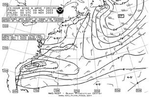
The hand-drawn charts showed highs, lows, isobars, and fronts for the Western Atlantic and Caribbean, from Newfoundland to Venezula. The maps on which the meteorological information was drawn look like they had been photocopied too many times, with a grainy and crude appearance. The charts were scanned and sent to us as e-mail attachments, yet despite this, the quality of the image did not exceed what one would expect from a fax. The service paid-for includes one free verbal update while en route (unexercised in our test), with the yacht bearing any communications expenses involved. Additional updates, either verbal or via e-mail, come at an extra cost. The forecast from Commanders’ Weather cost $90.
Locus Weather. We bought the “Departure Package” from Locus Weather. It consists of a preliminary forecast two days prior to departure, and a final departure forecast. Forecasts from Locus Weather are entirely text-based, without accompanying weather charts. The two forecasts we received were approximately 900 and 1,000 words. Both forecasts spent several hundred of those words describing in detail the position and predicted movement of weather systems—information we believe would be better conveyed in a chart. If Locus Weather were to have been the only forecaster for the delivery, we likely would have plotted out on a chart the systems described by the text. Unlike the other two commercial forecasters we used, Locus does not give a table of predicted wind directions and strengths. When we asked, the company meteorologist explained that “the weather does not conform to a table,” and that significant events may be missed by such a format. The Departure Package from Locus Weather cost $125.
We paid $65 extra for a Gulf Stream analysis from oceanographer Jenifer Clark. Clark provides an analysis of currents within the Stream, as well as in outlying warm and cold eddies. We received an e-mail of approximately 1,000 words, plus charts, in color and black-and-white, of the Gulf Stream analysis. A routing suggestion to avoid adverse currents and take advantage of any favorable ones is also part of the service. More about Clark’s Stream forecast later.
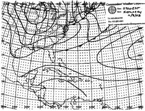
Real Weather Ltd. We bought the “Delivery Package” from Real Weather. It consists of three consecutive forecasts, starting two days before the scheduled departure date. Like the product from Commanders’, the forecast from Real Weather was organized into a text discussion of the overall weather scenario, a table of wind speeds and directions at six-hour intervals, and weather charts covering six days. We received our first two forecasts from Real Weather on 11/6/03 and 11/7/03, based on the assumption of a departure on 11/8/03. The forecast text and charts were delivered via e-mail.
The text portion of the Real Weather forecasts ranged from 400 to 850 words. The first forecast we received focused primarily on the overall weather picture, while later installments gave more detail on expected wind and sea conditions, and stated the meteorologist’s assumptions and caveats. The image files for the charts were not conventional e-mail attachments. Instead, the email contained links to the files residing on the company’s web server. The images would appear within the e-mail only if our laptop was connected to the Internet. The text of the e-mail was careful to point this out, and instructed us to “Right Click” and “Save As” the images to the laptop hard drive for use when the laptop was not connected online. We followed these instructions, though the resultant file extensions were not ones recognized by our image-viewing software. It took some creative manipulation of the file extensions to get the images to open.
The forecast from Real Weather cost $225. Purchasing an additional forecast for the second leg of the delivery, from Bermuda to Tortola, would have cost $125.
Herb Hilgenberg, South Bound II. For an additional opinion, we contacted Herb Hilgenberg, who runs a free weather forecasting and yacht routing service as a hobby out of his home in Burlington, Ontario. Hilgenberg delivers his advice daily by SSB radio—typically a four- or five-day forecast for the route, with routing suggestions and waypoints. To be added to his South Bound II roll call, a yacht must contact him by SSB radio on his frequency. Consult his web page (see the contact information) for further instructions.
Hilgenberg, well known to East Coast passagemakers, and to the Coast Guard for several important assists and radio relays he has made in times of emergency, is in contact daily with the many yachts on his roll call that are sailing the common bluewater routes. The yachts benefit from daily updates on the forecast, while Hilgenberg’s forecasts benefit from the observations that the yachts feed back to him.
Internet Research
We conducted our own weather research on the Internet, starting several days in advance of the departure date, to get an overall picture of weather patterns and trends. See the sidebar for a list of the websites we monitored. We visited the websites about every six hours, saving copies of weather charts to folders on a laptop.
The weather patterns prior to departure showed a low over Hudson’s Bay, which was forecast to move rapidly into the Gulf of St. Lawrence region. The cold front associated with this low was forecast to sweep eastward across the New England States during the night of 11/7/03 to 11/8/03, and then move offshore south of Nova Scotia. The 48-hour surface forecast chart available on 11/7/03 showed a high-pressure system moving in from the western Great Lakes region to dominate the eastern seaboard. The 96-hour surface forecast chart (valid for 11/11/03) showed the zone of high pressure to the north of Bermuda, while a low-pressure system in the Great Lakes region raised the possibility of unsettled weather on our route by 11/12/03 and 11/13/03.
Text forecasts by the NOAA’s National Weather Service (NWS) are readily available in a variety of sources: VHF, HF, NAVTEX receivers and the Internet. The NWS text forecast issued at 1500 EST on 11/7/03 for the offshore forecast zone “South of New England” predicted for 11/8/03 (the provisional departure date) winds north to northwest winds at 20 to 25 knots, diminishing to north to northeast from 15 to 20 knots that night. The yacht would leave this forecast zone after less than 24 hours underway, and move into the next forecast zone further offshore. The forecast issued at 1500 EST on 11/7/03 for the zone “Hudson Canyon to Baltimore Canyon” made a 48-hour prediction for winds of 10 to 20 knots from the north to northwest, diminishing to 10 to 15 knots by nightfall. The 72-hour prediction called for variable winds, 10 knots or less. However, the yacht by that point would be well out of the area covered by the text forecast. This highlights precisely why yacht owners turn to commercial forecasters. Beyond the boundaries of the NWS’s offshore forecast zones, a yacht must use the high seas forecast issued by the NWS for the entire North Atlantic. With a lot of ocean to cover, the high seas text forecast focuses only on major storms and gales, with specific predictions for wind and seas only for the areas affected by those storms. The NWS North Atlantic high seas forecast issued 11/7/03 made no mention of conditions along our proposed delivery route.
The Departure Decision
All forecasters recommended that we delay the departure from the planned date of 11/8/03. Commanders’ Weather called us on 11/7/03, to warn us that the next day “may be a bit rugged,” with gusty NNW winds of 20 to 30 knots. Conditions indeed were a bit rugged: the C-MAN station at Buzzards Bay recorded wind speeds above 10 m/s for each 10-minute reporting period during the morning of 11/8/03, with a peak wind speed of 14.9 m/s – that’s 29 knots. But the main issue was not so much the conditions immediately outside the harbor, but the sea state in the Gulf Stream a day and a half after departure, when the yacht would be due to arrive in the Stream. All forecasts available prior to departure indicated the potential for strong winds opposing the Gulf Stream current, which can bring about high, even dangerous, seas. Though initially strong, the winds were forecast to diminish in strength and veer as the area of high pressure moved offshore. It was therefore important not to arrive at the Stream too early. The drawback to delaying departure would be light headwinds later in the passage. Locus Weather recommended delaying the departure until 11/10/03, though in retrospect, following that advice might have put the yacht into some unpleasant conditions in the approaches to Bermuda.
The decision to delay the departure by 24 hours did not incur any additional charges from Real Weather; the company simply held off the delivery of the final of the three forecasts until 11/9/03. By contrast, to receive a forecast from Commanders’ on the new day of departure would have been an additional $90.
NOAA maintains a network of weather buoys that faithfully record weather and sea conditions. (See the web address for the National Data Buoy Center.) Station 44004, about 180 miles offshore and 55 miles southwest of the Newport-Bermuda rhumbline, recorded the wind strength in the days surrounding our delivery. The data show that delaying the departure by 24 hours put the yacht in more benign conditions on 11/10/03. The data plot also bears witness to the arrival of the next frontal system later on 11/11/04.
Further Internet Research
The decision to delay the departure by 24 hours gave us the chance to get on the Internet for the latest charts from the NWS. For those inexperienced at reading the isobars of a surface analysis chart and knowing the implications for wind direction and strength, a wind-wave analysis chart is particularly useful. The 24-hour wind and wave forecast chart for the Eastern Seaboard available in the early morning hours of 11/09/03 showed winds at 15 knots from the north-northeast for the waters south of Newport.
We looked to wind-wave forecast charts for conditions farther into the upcoming delivery, and again saw why blue-water cruisers and delivery captains turn to private weather forecasters. The 48- and 96-hour wind-wave charts cover the entire Atlantic, from the North Sea to the Gulf of Mexico, so coverage of our delivery route is very poor. On the 48-hour chart, for instance, four wind barbs on the chart bracketed our route, but most were over 100 miles off our route. Public weather services provide forecasts for the widest audience possible, which means that the details may not be specific enough for a particular use, such as a delivery.
The Departure
Clover III departed Newport at 1300 local time on November 9, in a light northwesterly breeze. Motorsailing was the order of the day, as it was for the majority of the trip. All weather forecasters were correct on the predicted wind direction, but all had overestimated wind strength. With the high pressure over the Great Lakes predicted to move to the north of the route, the forecasters were unanimous in calling for a clocking of the wind direction. The forecasters disagreed, however, on how quickly the veer would occur: Locus Weather had the wind shifting through 180 degrees in less than 24 hours, while Real Weather had the veer progressing at a much slower rate of approximately 10 degrees every six hours; Commanders’ and Hilgenberg were roughly in agreement on a shift to the northeast by the time the yacht reached the Gulf Stream. As it turned out, the wind stayed primarily out of the north-northwest for the first 24 hours, with occasional bounces into the northeast. Score: Real Weather – 1, the rest – 0.
The Stream Crossing
Commanders’ and Real Weather both provided us with a copy of a Gulf Stream chart issued by Naval Atlantic Meteorology and Oceanography Command (NLMOC). Commanders’ quite literally gave us the NLMOC chart issued 11/07/03, without modification or value-added information. Real Weather provided us with the same chart, with the north and south walls of the Stream highlighted and a legend added. The NLMOC chart conveys data on sea temperatures (in degrees Celsius), the location of the north and south boundaries of the Stream (dashed lines), and the Stream’s set (arrows) and drift (bold labels).
The Gulf Stream analysis from Jenifer Clark, provided as part of the package from Locus Weather, provides far greater detail than the NLMOC chart, particularly concerning the location of eddies outside the Stream. Clark’s own computer model of the Stream placed a cold eddy near 35N 68W, where the NLMOC chart issued prior to departure showed nothing. Clark’s identification of the cold eddy was also supported by observations reported by other customers of hers who had done the route a few days before us.
Commanders’ and Real Weather both recommended waypoints at which to enter the Gulf Stream. Real Weather also provided a waypoint for exiting the Stream. Hilgenberg provided two waypoints; one on each side of, and both significantly far from, the rhumbline. Clark’s suggested route was far to the west of the rhumbline, primarily to avoid the unfavorable east side of the large counter-clockwise-circulating cold eddy south of the Stream. Hilgenberg also detected this cold eddy and so recommended using the western of his two waypoints.
The yacht arrived at the north wall of the Gulf Stream near local midnight on the second night out. Though perhaps not the ideal time to arrive at the Stream, the Stream crossing was the quietest that any crewmember could remember.
Winds for the second 24-hour period were very light, mostly under 10 knots; the wind direction initially made an abrupt veer into the southeast, before settling back to a consistent 70-90 degrees, maintaining that direction for several hours. The yacht relied increasingly on the engine for propulsion. Locus Weather, with its prediction of a massive shift in the first 24 hours, was by this point in the passage predicting south and then southwest winds, well beyond the actual direction. Hilgenberg, too, overestimated the progression of the veer, calling for southeast winds. Commanders’ and Real Weather both believed that the veer would occur gradually, so predictions issued by these two forecasters had to catch up to actual conditions during this period. All forecasters overestimated wind strength during the second 24-hour period. Perhaps the closest prediction for the period in terms of wind direction and strength was Commanders’, with a prediction for the morning of 11/11/03 of winds from 040-060 degrees at 5-10 knots, which is not too far off the observed conditions of 070 at 3-6 knots. Score one point to Commanders’.
Since Clark’s suggested route would have added approximately 100 miles to the passage, the skipper made the decision to stick to the rhumbline. However, the cold eddy turned out to be significant, as the yacht was in the grips of an unfavorable 1.5-knot current for well over 60 miles of motoring south of the Stream. It’s difficult to say whether the extra distance of the Clark route would have been worth avoiding the adverse current.
Though Clark’s Stream forecast comes as part of the package from Locus Weather, the routing suggestion aims to find the optimal solution to oceanographic (i.e., current), not meteorological (wind), conditions. Score a bonus point to Clark for nailing the cold eddy.
From the Stream to Bermuda
By the time the yacht exited the Stream, it was firmly in the grasp of the high-pressure system. The wind remained light (5-6 knots), primarily out of the east. The yacht was by this point motoring continuously. On the morning of the third day (11/12/03), while still 170 miles from Bermuda and with fuel consumption starting to be a concern, the crew used the laptop and Iridium phone to go online to the NWS site and download wind-wave charts, both current and 24-hour forecasts. The charts showed winds in the vicinity of Bermuda blowing from the south-southeast, ranging from 10 to 20 knots, clocking later to south-southwest 15 knots.
Mid-way through the third 24-hour period of the passage, the winds increased in strength and shifted into the south. Rain squalls brought stronger winds, at times hitting 20 knots, out of the southwest. The last 100 miles of the passage were sailed in moderate southwest winds. In terms of making the correct predictions for wind strength and direction in the later stages of the delivery, Commanders’ was perhaps the most accurate.
It’s interesting to note that only Real Weather contacted us to find out whether the yacht arrived safely in Bermuda. Bonus marks for good customer service to Real Weather and follow-up.
Analysis
“Weather Forecasters’ Predictions vs. Conditions” (see sidebars) compares the predictions for wind direction and strength made by the commercial forecasters with actual conditions experienced. In the case of Commanders’ Weather and Real Weather, these predictions were organized in tables of six-hour intervals. The table also gives the forecasters’ assumptions for the yacht’s position, as well as the yacht’s actual location for the time. As noted above, Locus Weather did not provide a table of predictions for wind direction and strength for every six hours of the delivery. Reading the forecaster’s text, however, we found that the predictions for wind speed and direction followed a “morning, noon, evening, night” pattern, so we thought it legitimate to put the Locus Weather predictions alongside the other commercial forecasters in the comparison table. To put Hilgenberg on equal footing with the other forecasters in this comparison, we have included the forecast he issued on the day of departure.
Each forecaster is right on some things and wrong on others; there really are no standards for overall accuracy. Commanders’ was perhaps the closest on the timing and ultimate direction and strength of the veer as the high-pressure system moved over the delivery route. Hilgenberg was also remarkably accurate. To be fair to Real Weather, the text portion of the forecast did discuss at length the possibility of southwesterlies in the approaches to Bermuda. Locus Weather was probably the least accurate in terms of wind direction and strength over the course of the passage, but again, it would be wrong to judge overall accuracy on the basis of one test. Weather forecasters can’t be expected to predict three days in advance the exact wind direction and strength of winds in the middle of a high-pressure system. The same passage in a different weather scenario with a well-defined pressure gradient might have had more easily predictable winds. Each forecaster did the job required of them: to put the yacht in benign conditions for a safe and unhurried delivery.
Choosing a Weather Forecaster
It’s important to choose a private weather forecaster who understands the characteristics of your yacht, its speed, and the seas it can handle. Perhaps more importantly, the forecaster must get to know what kind of sailing you do and what your goals and thresholds are for safety and comfort. Also consider finding a forecaster with expertise in the waters of your planned voyage, as there are forecasters who specialize in different areas. The forecasters we used have ample experience with deliveries from the U.S. East Coast to the Caribbean, their industry’s bread-and-butter.
If we had to make a choice on a for-pay forecaster based on this single comparison, we’d go with Real Weather. Their forecasts were strong, if not tops, and we appreciate the smart marketing—not charging extra when there are delays relating to weather, and a discount for multi-legged deliveries. The good customer service and follow-up from this company also impressed us. And we would stay tuned to Herb Hilgenberg, who gives good advice at the perfect price.
Also With This Article
“Weather Forecasters’ Predictions vs. Conditions”
Forecasts and Charts Online
National Weather Service – Marine and Coastal Weather Services
www.nws.noaa.gov/om/marine/
National Weather Service – Weather Charts on the NET
weather.noaa.gov/fax/ (NB: No ‘www.’ prefix)
NOAA – Ocean Prediction Center
www.opc.ncep.noaa.gov
NOAA – National Data Buoy Center
www.ndbc.noaa.gov
Naval Atlantic Meteorology and Oceanography Command – For Gulf Stream charts
https://www.nlmoc.navy.mil (NB: The string ‘https://’ is important – don’t leave out the character ‘s’.)
Contacts
• Commanders’ Weather, 603/882-6789, www.commandersweather.com
• Jenifer Clark, 301/952-0930, www.erols.com/gulfstrm/
• Real Weather Ltd., 401/841-0287, www.realwx.com
• Locus Weather, 207/236-3935, www.locusweather.com
• Herb Hilgenberg, E-mail: [email protected],www3.sympatico.ca/hehilgen (NB: The character ‘3’ is important.)


