

Today, inexpensive handheld GPS receivers are marketed to a wide-range of users, not just sailors and power boaters. Most carry generic software of little specific value to mariners. Even marine designations are more marketing than content it seems. Still they do one thing very well and that is track GPS satellites.
For the mariner, they can serve as a viable backup to a permanently installed onboard navigation system, with a sextant safely on board, but tucked away. Accurate position, speed, and course information supplied by a handheld GPS used in conjunction with paper charts should be all any sailor needs to complete a long, planned voyage. When so equipped, these devices also do well at supplying accurate lunar, solar, and tidal data in an easy-to-access, user-friendly format—information that’s critical for making landfall in unfamiliar ports.
What they don’t do well is display easy-to-read map data. Past testing has shown the charts on handheld units to be lacking in accurate marine details. Two factors contribute to this problem. First, the screen size on a handheld unit is simply not large enough to display the huge volume of data needed to make a chart display useful and accurate. Second, memory and processor capability is limited in a small handheld device, and unfortunately a good map display requires lots of both. We don’t see either of these problems going away anytime soon in low to moderately priced handheld GPS units.
What We Tested
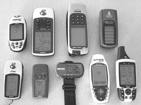
We cast our net around a broad group of handheld GPS units, each specifically chosen because it does not use cartography on a card. Some of these we have tested before, while some are new to the market. Our goal was to keep the price point at the lower end of the market, though some units have additional features that push their prices higher. Two units come in under $100—the Garmin eTrex and the GPS100 from Cobra. Our mid-range units, between $100 and $200, include the Garmin Fortrex 201, Garmin Geko 301, Garmin GPS 76, and the Magellan eXplorist 200. In the upper echelon, at $250 is the Magellan SporTrak Pro Marine, and the highest priced unit in the test is the Brunton Multi-Navigator at $299.
How We Tested
Position locating accuracy is a given with current GPS technology. Therefore, we didn’t specifically test this, but instead compared all the systems against each other to determine that each was precise in this regard. All the units consistently self-located within a 10-foot circle of the group, so all garnered the same accuracy ratings.
To obtain a rating on marine friendliness we concentrated our analysis on each unit’s ability to display information. On each machine we looked at the variety of the information available, how useful the data is to mariners, and the ease with which users can manipulate that information.
Our display ratings are based on screen viewability in daylight and darkness. Another aspect of the display rating is readability: Can the number, words, and symbols be seen easily or are they blocky and difficult to decipher? Easy-to-read screens were rated highest. Unit size and comfort in hand, plus the ability to manipulate the push buttons and keys led us to the ergonomic rating for each unit. If a unit could be easily held and operated in one hand without blocking the display screen, it was highly rated.
All of our test units claimed to be waterproof; to verify this claim we fully submersed each unit in a tank of freshwater for five minutes. Every handheld worked properly after the water immersion; we even inspected the battery compartments and discovered no water in any unit. One, however, failed to operate the day after the immersion test.
In the final analysis of each handheld GPS, we used ratings, price, and warranty information to determine winners.
Brunton Multi-Navigator
Brunton’s MNS is one of the larger units tested and the most expensive at $299. The nearly 3″ (diagonal) screen is located toward the bottom of the front panel with a leveling bubble in the extreme lower right corner. Nine pushbuttons are located above the screen. The unit fits comfortably in either hand, and the buttons can be operated by the thumb without blocking one’s view of the screen. Because the pushbuttons are marked with symbols only, not nomenclature, we had to refer to the manual for pushbutton function information more often than we liked.
Five main function pages, Position, Altitude, Baro, Time/Date, and GPS are each selected by pressing the up or down arrow keys. Sub-menus are available by pressing right or left arrow keys. Pressing the keypad’s center button accesses the Compass page. It can be selected with the power on or off. The waypoint main page is selected by pressing the waypoint key then hitting the arrow keys to scroll through sub-menus. That’s right, this unit has no map display, not that maps have much value with the small screens used on handhelds. That makes this product more akin to a vintage GPS unit with text-only display. Using the Brunton MNS is like stepping back in time to the days of the Garmin 50.
In addition to the standard GPS functions, the MNS has an altimeter, a compass, and a barometer. The altimeter has little value for boaters. The compass reads in degrees and could come in handy in the unlikely event that your onboard compass failed. We found it fairly accurate when held stable, but the reading jumped around somewhat when pitching and rolling—not unlike a wet compass.
The Brunton MNS’s screen has a proprietary layout with text above and below a compass rose located center screen; as such, no screen resolution numbers are supplied by the maker. We found the information displayed on the screen easy to see in direct sunlight and shade, however, viewing in daylight conditions with polarized sunglasses does darken the screen a bit. With the backlighting turned on, night viewability is excellent and all pushbuttons are lit.
The battery compartment, containing 2-AA batteries, is located on the bottom of the unit with the data port and carry strap. A 2-year warranty is standard on the MNS.
Bottom Line: Brunton uses software and screen technology that appears antiquated compared to the others we tested. Plus, it is the only unit without WAAS capability and failed to operate the day after our water immersion test.
Cobra GPS100
Best known for their CB radios and radar detectors, Cobra Electronics entered the handheld GPS field with two new products including the GPS100. With a street price of $92, this is one of the least expensive units in our group. It fits nicely in one hand and is controlled by a toggle switch on the front face, another on the side, and a side-mounted on/off button. The front toggle is labeled Page/Enter, with up/down arrows on the side toggle.
Like the Brunton, the Cobra has five main pages; each press of the Page button moves to the next page. The pages are Map, Gauges, Trip Meter, Nav Data, and Status. The Map page consists of a triangle representing your boat’s position on a blank screen. Only data entered by the user, such as waypoints, tracks, or routes appear. The Gauges page shows a compass rose indicating the present track with a single user-selectable data box on the bottom of the screen. The Trip Meter displays either 3 or 5 user-selectable data boxes; strangely the current course track is not one of the choices. In our opinion, this is a serious oversight. Waypoints, tracks, and routes are all accessible in separate menus under the Nav Data page. Seven alphanumeric characters can be used for a waypoint name.
The GPS100 screen has a rectangular shape and measures just over 1-inch wide and 2 1/8 inches high. Resolution is 64 by 128 pixels, making number and letters in small type a little jagged around the edges. Screen viewability in all lighting conditions was Good, however, none of the pushbuttons have backlighting.
Battery compartment access is on the back of the unit as is the optional power cord connection. A lanyard anchor is located on bottom left rear corner of the case. Warranty period is 1 year.
Bottom Line: A good unit available at a bargain price, with better software than the comparably priced Garmin eTrex.
Garmin Geko 301
Sized to fit in a shirt pocket, at just under 4 inches high and 2 inches wide, the Garmin Geko 301 carries the smallest display screen of our test group, measuring just 1.8 inches on the diagonal. Five pushbuttons located just above the screen control all functions. When holding the unit in your right hand and operating pushbuttons on the left side you’ll find your thumb and hand partially block your view of the screen. Pushbuttons are clearly marked with easy to understand symbols.
Six main pages provide the user access to all Geko 301 functions. The Satellite page shows the number of tracked satellites and their signal strength. Map is basically a blank screen showing a present position icon with range displayed in the lower left and heading in the upper right. Any user waypoints or tracks are also displayed. Due to the same size of the screen, we found the Map page of little use. The Trip Computer page is far more useful for navigating to a waypoint. Four user-selectable data boxes are displayed. We chose to use course, bearing, distance, and speed to make navigating to a waypoint easy. Other main pages include Menu, Elevation, and Navigation. The Navigation page can also be used to track to a waypoint. It displays a compass rose as well as heading in degrees, distance to the next waypoint, and a single data box at the bottom of the screen. The data box can be changed with up/down arrow keys.
The Geko has both an altimeter and compass in addition to its GPS functions. Like the Brunton, we found the compass accurate as long as the unit was held steady and level, otherwise accuracy was seriously compromised. We did not test the altimeter.
The Geko screen measures 1 inch wide by 1.6 inches high, with a resolution of 64 by 100. Like the Cobra, curved lines and small type appear jagged. Viewability was Good in sun and shade daylight conditions. Using the screen backlighting at night, we found the upper right hand corner slightly brighter, though the screen is still quite readable, and the pushbuttons are lit.
Access to the battery compartment and data port is on the back of the unit. The battery compartment holds a pair of AAA batteries and uses a snap-lock lid.
Bottom Line: We did not find the Geko’s small size to be advantageous and at $200, we feel other choices provide more bang for the buck.
Garmin Fortrex 201
By far the smallest unit we tested, the Fortrex 201 is only about two-thirds the size of its cousin, the Geko 301. It comes standard with a hook and loop fastened wristband and has the same size screen as the Geko, though the Fortrex is laid out in a horizontal format. Six buttons on the bottom of the unit operate all functions. Labels are marked on the unit’s front face above each pushbutton.
Like the Geko, the Fortrex has six main pages and all but one carry the same nomenclature and function. Since the Fortrex does not have an altimeter, the Timer page replaces the Elevation page, and functions as a stopwatch. We found the software in the Fortrex more advanced than that contained in the Geko. For example, the Trip Computer page in the Fortrex can display one, two, three, or four data boxes and all are user-selectable. The additional Go To pushbutton adds to the Fortrex functionality.
Screen resolution on the Fortrex nearly matches the Geko at 60 by 100, and like all the really small screens we tested, anything in small type or depicted with curved lines appears somewhat jagged around the edges. In total darkness, with backlight on, the Fortrex is easy to read though no buttons are lit. In daylight we found viewability Good in both sun and shade.
There is no battery compartment on the Fortrex as it contains a rechargeable, internal Lithium-ion battery. Data port access is on the back of the case.
Bottom Line: Day sailors aboard open boats like beach cats, or other boats with little weather protection and storage space might like the wristband feature of the Fortrex. Its reasonable $144 price and stopwatch feature adds to the appeal for this appliation.
Garmin eTrex
Garmin’s eTrex is the low price leader in our test group; we found it for just under $90. Five pushbuttons control the eTrex, three on the left side and two on the right. Holding the unit in one hand and operating the pushbuttons with the fingers on that hand does not block the view of the screen. Labels for the buttons are just under each button, however, the black-on-black color scheme offers little contrast and can make these buttons difficult to read. Our preference is for clearly marked buttons on the face of the unit, not side-mounts.
Only four main pages are used in the eTrex software package. Page 1 is a Satellite Status page with a simple bar level meter at the bottom to show signal strength. Page 2 is a Map page similar to the Geko and Fortrex. Page 3 is a Navigation page, which includes a compass rose with rudimentary markings at the cardinal headings in the center ofthe page. A single user-selectable data box is at the bottom of the screen. The last page is the Menu page with sub-menus for mark, waypoint, route, tracks, and setup. We certainly miss the Trip computer page contained in the other Garmin units and would have gladly given up the Map page to keep it.
The eTrex screen has slightly higher resolution than either the Geko or Fortrex, but due to the larger screen size, it still exhibits jagged edges on curved lines and small type. We found the screen easy to see under all lighting conditions, though no button backlighting is provided.
Both the battery compartment and data port connection are on the rear of the case.
Bottom Line: An economical GPS; though not as capable as the others, it will get the job done as a basic navigation aid.
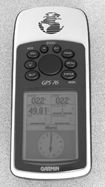
Garmin GPS 76
The Garmin 76 has been around for several years and has a proven track record of reliability. Overall, it is one of the largest units in our test group, but still fits well in one hand and can be operated with the thumb of that hand without blocking the screen view. Eight clearly labeled pushbuttons and a single rocker key with up/down and left/right movement provide the means for operating the Garmin 76.
Five main pages give the user access to all the Garmin 76’s features. The GPS Information page provides satellite status plus a myriad of other data, some of which include date, time, and present position. Another main page lists the current selected waypoint plus a list of nearby waypoints with the distance to each; it’s called the Active Route page. Navigational pages consist of the Map, Pointer, and Highway pages. A variety of layouts and data box information can be selected on any of the navigation pages. We found the Pointer page especially useful when displaying the compass rose, the name of the current waypoint, and six user-selectable data boxes. The Map page in the Garmin 76 does contain some useful marine data like buoy locations, light colors and sequences, and place names. Other information useful to the mariner include the solar and lunar tables, a best-times-to-fish chart, and a graphical tide display for a multitude of locations.
Boasting the highest resolution screen in our test and one of the biggest at 2.9 inches (diagonal), the Garmin 76 has finely defined letters and numbers with clean edges even when displaying small type or curved lines. Viewability is very good under all conditions. Because all named pushbuttons are supplied with backlighting, making them easy to read in the dark, the Garmin 76 garnered an Excellent rating for Display.
The rear of the case holds the battery compartment (2-AA), the data port, and the external antenna jack.
Bottom Line: Our top pick. Even though it’s been around for several years, nothing has surpassed it yet as a top choice of sailors. At $182.95, it’s a strong buy.
Magellan SporTrak Pro Marine
The layout of the SporTrak Pro has the screen in the mid-section of the face with all control buttons located near the bottom. The buttons are marked with symbols only and no words. At the outset, this requires some reference to the manual for correct button identification. Eight buttons surround a small cursor pad. We found it somewhat difficult to hold and operate the unit with one hand.
Six main navigational pages provide user access to the SporTrak Pro’s myriad of functions, a seventh; the main menu page, is accessible via its own dedicated pushbutton. The Map page differentiates between land and water, has buoy position and light information, and place names. Map detail levels can be adjusted to fit the user’s preferences. Additional map data can be downloaded as an option. Other navigation pages include the Compass, Position, Large Data, and Road. Each page provides a number of user-selectable data boxes in addition to the compass and highway graphical displays on their namesake pages. One quirky item we noticed on the Magellan: turning the unit on is a two-step process. If you don’t hit the enter key as prompted, the unit will turn itself off again in several seconds. This can become an annoyance, in our opinion.
The screen size on the SporTrak Pro is 2.6″ on the diagonal, and the resolution is 160 by 104, making details, curves, and small type somewhat difficult to read. Backlighting on this unit is activated with an off/on button and we found it easy to accidentally turn the unit off while trying to turn on the lighting. Once on, the backlighting works well, illuminating both the screen and buttons with two levels of light. Day viewability was good under all conditions.
The battery compartment is located on the bottom of the case with the data port unprotected on the back.
Bottom Line: Our runner-up; it only lacks some of the ergonomic niceties of the Garmin GPS 76.
Magellan eXplorist 200
The eXplorist 200 is a bit smaller than both the Magellan SporTrak Pro though it carries the same layout with the screen located mid-case and pushbuttons below. Everything is downsized somewhat; the eXplorist screen measures 2.3 inches on the diagonal and uses the smallest pushbuttons of any test unit. In place of the cursor pad found on the other two units is a micro joystick serving as the up/down, left/right arrow key and the enter button. Seven other small pushbuttons are located around the joystick and are clearly marked with both symbols and word labels. Like the other units that share this layout, we found it difficult to hold and operate the eXplorist with one hand.
The menu page on the eXplorist has its own button for display while four navigational pages are displayed by pressing the Nav button. They are the Status page, showing a partial world globe with satellites in position and signal strength; the Map page, showing limited land/water separation and no marine information (also has a pair of data boxes at the bottom of the screen). Only nine items are available on the list of data choices, too short a list, in our opinion. The Compass page displays a compass rose and two data boxes. The final page is the Position page listing current position, battery status, date/time, a trip odometer, and a signal accuracy number. The lack of marine information, limited software versatility, and the fact that waypoints in the eXplorist are referred to as “My Pts of Interest”) imply that this unit is not aimed at the mariner.
Backlighting is activated by a pushbutton on the upper left side of the case. Two levels of red light are available for the screen, but none of the control buttons are lighted. In our opinion, this unit would be difficult at best to operate in the dark of night. Daytime viewability was good.
Battery compartment access is on the case back. The eXplorist does not have a data port or alternate power cable hook-up.
Bottom Line: The eXplorist lacks the ergonomic features and software versatility of the other units we tested.
Conclusions
The map pages found in these handheld units are not very useful to the mariner and we shy away from them when navigating with a handheld. The information supplied on even the easy-to-read displays like the Garmin GPS 76 is still too small and too difficult to use while underway. We recommend sticking with navigation pages that supply the necessary data in crisp large text.
Another area of concern is the continual reduction in the size of these units. At some point, especially for mariners, who have no real need for the smallest screens available or pushbuttons sized for children’s digits, it all becomes rather ridiculous. The rule of diminishing returns definitely applies here. Our preference is for units that fit and feel solid in hand, have pushbuttons big enough for adult fingers, and screens we can read without a magnifying glass.
With those thoughts in mind and after a critical review of each unit’s features, we have settled on the Garmin GPS 76 as our top pick. A second choice, if you can overlook the small pushbuttons, would be the Magellan SporTrak Pro. In the more inexpensive category, we’d opt for the Cobra GPS100 , because its extra navigation page bests the other units priced under $100.
Also With This Article
“Value Guide: Handheld GPS Units”
Contacts
• Garmin, 913/397-8200, www.garmin.com
• Magellan (Thales Navigation), 800/669-4477, www.magellangps.com
• Cobra Electronics, 773/889-3087, www.cobraelectronics.com
• Brunton, 800/443-4871, www.brunton.com


