


Software for downloading e-mail, weather information, and tide information from the Internet over a high-seas radio or a satellite phone gets used most frequently aboard cruising boats. Because of the slow e-mail transmission rates on the high seas, data-compression software is a must to keep communication cost-effective, whether youre using a ham radio, cell phone, or satellite phone. Some of the more popular software packages for offshore e-mailing are Airmail, Winlink, XGate, UUPlus, and SailMail. Once high-seas e-mail has been set up, users can download weather information from a variety of sources, including NOAAs GRIB file system, Saildocs, and ViewFax. Weather fax is still important despite the increasing popularity of GRIBs (Gridded Binary files), but youll need a software program that can read the charts. Some our testers have tried include Xaxero and Mscan Meteo.
****
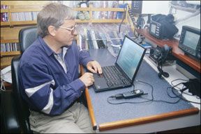
A wealth of software exists to assist the offshore cruiser in everything from communicating with the outside world to determining the most efficient course given a five-day wind forecast. Those who can afford it often leave with a laptop loaded with dozens of programs, some of which cost thousands of dollars. Once on passage, though, most cruisers realize that these programs arent very useful offshore and arent worth the energy required to run them. My partner, Evans Starzinger, and I, like most other offshore sailors we meet, have ended up using fewer than a half-dozen programs regularly, but these are applications we would not choose to do without. Software for downloading e-mail or weather information from the Internet over a high-seas radio or a satellite phone gets used most frequently aboard cruising boats. Weather fax software is still important despite the increasing popularity of GRIBs (Gridded Binary files), and tide software provides essential information when making landfall. Finally, we carry some specific information resources that have proven valuable while on passage.
OFFSHORE E-MAIL
To send and receive e-mail when out of reach of Wi-Fi and out of range of cell towers requires a computer and either a satellite phone with a data kit or a high-frequency radio with a modem, a data cable, an antenna, some software, and specialized land-based servers. Whether using a satellite phone or a high-frequency radio, transmission rates for high-seas e-mail systems are agonizingly slow by shoreside standards. (See “Communications Cost”)
These transmission rates are significantly slower than using a dial-up connection over a low-speed landline. For this reason, high-seas e-mail systems are designed to accept only short to medium-length, plain-text e-mails. Specialized Internet Service Providers (ISPs) have created e-mail services and software programs designed for the limitations of low-bandwidth communications. E-mails are composed offline using a standard e-mail program like Microsoft Outlook. These are then forwarded to the high-seas e-mail program which dials in to a specialized server, retrieves any mail waiting there, passes along any messages to the outbox, and then shuts down. Servers for high-seas systems generally strip off any attachments and use complex compression algorithms to increase transmission efficiency.
To do e-mail over a high-seas radio, a Pactor modem must be installed. This may cost as much as $1,250 and must be configured for the protocol supported by the land-based servers. The system uses a backstay SSB antenna, and the Pactor modem will come with a data cable for connecting to the computer.
Though your modem may come with a software package, most ham-radio users prefer
Airmail (http://www.airmail2000.com/) which can be downloaded from its website. Ham users can be patched into a Winlink (http://www.winlink.org/)or Netlink server by a shore-based ham. The Winlink website provides complete information on configuring to do e-mail over a ham radio.
If using a marine SSB, you can access land-based “host” stations run by a nonprofit cruising group directly on designated frequencies. Users pay a fixed fee of a few hundred dollars annually for this service, called
SailMail (http://www.sailmail.com/). Detailed information can be found at the website along with the downloadable SailMail software.
Radio-based systems are extremely inexpensive, but they are also dependent upon the propagation of radio waves through the atmosphere to work. There may be times when atmospheric conditions will not allow you to get through, or when others broadcasting in your vicinity with a stronger signal block you from getting onto the system in the first place. In addition, SailMail restricts the size of messages sent and received and total use per week.
To e-mail over a satellite phone, youll need a data kit, including a data cable and software for allowing the phone and computer to communicate. The
Iridium (http://www.iridium.com/)phone comes with a small antenna attached, but for e-mailing, a separate external antenna mounted on the outside of the boat will make it possible to e-mail from the nav station without taking the computer outside. While not essential, this is certainly convenient and saves wear and tear on the computer.
Several Internet service providers cater to the satellite phone market. Although it is possible to use a satellite phone just as you would a cell phone or a phone on shore to browse the Internet or to check e-mail, the incredibly slow data rate and the cost per minute make this highly inefficient and prohibitively expensive. Just downloading a single web page can take 10 minutes or more. The most sophisticated of software systems for satellite phones have been carefully designed to cut airtime to the absolute minimum.
We have used
XGate (http://www.globalmarinenet.net/) for the last several years. This program reduces transmit time by using ultra-high compression rates, stripping off all attachments, filtering all spam and sending and receiving at the same time. Using this program, we can upload and download a half-dozen e-mails in about a minute over our Iridium phone as opposed to eight minutes or more when going directly to a normal ISP, making it affordable for us to e-mail daily. Quite a few of our friends use and recommend another satellite phone ISP, UUPlus (http://www.uuplus.com/), which uses its own proprietary software.
Our Iridium phone is set up to communicate with the computer through a serial port. Our newest laptop did not come with a serial port, so we needed a USB-serial port adapter for e-mail. When getting ready to configure your system, check adapter requirements and make sure you have the necessary connections before heading offshore. Thoroughly test the system before setting out. Some marine software will not work with the new Microsoft Vista operating system.
Whether using a high-frequency radio or a satellite phone for e-mail, you will end up with a new e-mail address associated with the dedicated ISP for your onboard e-mail system. This address should be distributed very selectively to family and close friends with strict instructions on its use, including no e-mails over about 30 KB (a half-page of plain text), no attachments, no jokes, and no photos. The address should never be included in a distribution list except as a blind cc.
WEATHER FILES
Once the boat has been set up for offshore e-mailing, it becomes possible to download weather information from the Internet to your e-mail address. Marine text forecasts for your high-seas forecast area can be downloaded directly from the National Oceanic and Atmospheric Administration (NOAA) or via e-mail request through
Saildocs, (http://www.saildocs.com/). In addition, most sailors download the GRIB files.
GRIB files are compressed weather maps specifically designed for efficient transmission to offshore vessels equipped with low bandwidth receivers&emdash;high-frequency radios (Ham or SSB) or satellite phones. These special-request files are obtained by accessing NOAA weather databases to retrieve information tailored to the user. They offer almost unlimited flexibility in selecting weather information, with the user specifying the reporting area, the type of information required, and the forecast period.
The information that can be downloaded includes wind speeds and directions displayed as wind arrows, surface pressure, 500-millibar charts, and wave heights for up to 15 days ahead (though accuracy declines markedly after the first 24 to 48 hours). To download them on the boat requires onboard e-mail capability and software to read the GRIB files.
GRIB files can be downloaded from several different sites on the Internet (see “Options abound for grabbing a GRIB weather file,” page 19). Each of these sites includes an explanation of how GRIB files work and how to access them through that site, and the sites provide software for reading the GRIB files once downloaded. We currently use
ViewFax (http://www.siriuscyber.net/wxfax/), developed by Jim Corenman (who also wrote the software for SailMail and AirMail). Corenman has generously made this program available for free. We access the GRIBs for free through SailDocs by sending a coded message detailing the type of information and the area. For detailed information about requesting GRIBs from the SailDocs robot, send a blank e-mail to GRIBinfo@saildocs.com.
GRIB files are raw data plucked from NOAA databases without human intervention. They are not quality controlled, and they require interpretation by the user. They may not show compact systems such as meteorological bombs and tropical depressions and they don’t show local land influences on the weather. As a result, we have found them much more useful in the open ocean than when coastal cruising. Even at sea, we have learned to be skeptical of any GRIB “forecasts” beyond 24 hours. Despite these drawbacks, they have often given us several days warning of large, well-established, intense high- and low-pressure systems, giving us time to maneuver as these approached.
WEATHER FAX
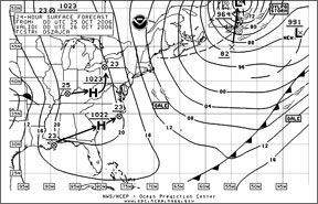
Most countries disseminate various types of weather information by weather fax several times per day on a specific schedule. These include synoptic charts, such as that shown on the facing page, and satellite images as well as 12- and 24-hour prognoses (with some providing prognoses for up to five days). Once the system has been set up, faxes can be received without charge. Weather faxes provide the easiest and least expensive way to receive weather information aboard, but reception depends on radio propagation. Further, the faxes cover large areas, and therefore lack resolution. Although they identify the largest systems and their movements, it can be difficult to determine the exact conditions you might experience in the following 24 hours.
Faxes can be received via a dedicated weather fax machine or through a high-frequency radio receiver attached to a laptop computer via a simple audio cable. The laptop must be loaded with a software program to read the charts. We have used both
Xaxero (http://www.xaxero.com/) and Mscan Meteo fax (http://www.mscan.com/) and like both of them. (Practical Sailor tested the Meteo fax in 2001. The review ran in the May 1, 2001 issue.) To get a decent fax picture, as much RF noise as possible needs to be eliminated during fax reception. We turn off instruments and autopilots and run our laptop computer off its own internal battery when receiving a fax, as almost all of the cigarette lighter adaptors and 110-volt inverters produce too much RF noise. Those with desktop computers aboard may have difficulty in downloading a readable fax. Fax schedules for the world can be downloaded from the NOAA website at www.weather.gov/om/marine/rfax.pdf.
TIDE SOFTWARE
When making landfall, sailors need to know the state of the tide and of any currents that might affect them. Tide and current tables are perfect applications for computers&emdash;large databases of information that must be easily searched. We have tried several tide programs, but our favorite is freeware called
WxTide32 (http://www.wxtide32.com/). It has proven accurate with more than enough reporting stations every place we have been, including areas with extreme tides and currents such as Chile, New Zealand, and the Pacific Northwest.
OTHER RESOURCES
In our opinion, using a laptop to run routing software, and even for chartplotting, consumes too much power. However, there are a couple of other resources that we turn to on occasion when offshore and find useful to have aboard.
StarPilot (http://www.starpilotllc.com/)is a celestial and sailing calculator that we use primarily for identifying stars and planets while underway. We have not used it for sextant sights in many years, but we would if we ever lost our GPS.
We use the computers DVD drive to access various reference books. The
Seven Seas Cruising Association, (http://www.ssca.org/)sells a CD with five years of SSCA Commodores bulletins in a searchable format. These bulletins, consisting of letters from SSCA members, include detailed information on each country including where we can get fuel and water, which anchorages offer the best protection, which areas might be unsafe, and issues with clearing in or clearing out.
Bowditch on CD answers any navigational questions we might have, and the Merck Manual on CD provides us with medical information, diagnosis, and treatment. We also carry two encyclopedias (Britannica and Encarta). These have proven tremendously valuable when we have a question about the place we are about to visit or some news item on the BBC. We prefer the DVD versions where all the information fits on one disk rather than the CD versions which require multiple disks.
While much attention is focused on routing and charting software, our primary offshore software applications are communications via e-mail and weather information. If you intend to be connected while offshore, it pays to make sure you have these two applications sorted out before investing in other expensive applications.
Beth Leonard and her partner, Evans Starzinger, have left more than 85,000 miles in their wake. They are currently bound for southern Chile aboard their 47-foot Van de Stadt-designed aluminum cutter, Hawk.


