


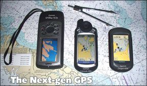
Garmin’s new scroll-wheel Colorado 400c and touchscreen Oregon 400c offer some unique features, but their multi-sport focus falls short in satisfying all of a mariner’s needs. Although both new units are high-quality handhelds, testers preferred an older-generation GPS, the Garmin GPSMap 76CSx, which was the Practical Sailor Best Choice in a previous test. Practical Sailor tests compared the units’ features, performance, ergonomics, and price, along with how well they meet sailors’ needs.
****
It’s been two years since Practical Sailor examined handheld GPS devices, one of the fastest evolving categories of electronics. Among the most significant changes
288
since that test is that Garmin has firmly cemented its hold on this market. The nearest competitors in the marine handheld GPS arena, Magellan (a shell of its former self) and Lowrance (now under the Navico umbrella), have mere toeholds by comparison.
While Practical Sailor’s testers have been impressed by Garmin’s handheld products in previous tests, the thinning field of makers raises concern. Without any real competition to spur innovation in the marine market, will Garmin ignore the needs of boaters for the sake of attracting more drivers, hikers, and geocache aficionados? Practical Sailor readers may remember that the Best Choice in the previous test, the Garmin 76CS Plus (no longer available), was a Garmin unit that had been purposefully modified with input from West Marine to better meet boaters’ needs and budgets.
Although neither Lowrance nor Magellan seem to be heavily marketing their newest handhelds to boaters, we plan to look at their latest offerings soon. In the meantime, the release of two new Garmin handheld series, the Colorado and the Oregon, gave us an opportunity to check the direction Garmin handhelds are heading. The names suggest that the nation’s waterways aren’t the primary targets for these units, but each holds promising new technologies that testers were eager to try. The Colorado series features an iPod-like scroll wheel, while the Oregon series touts a touchscreen, which is quickly becoming the norm among handheld devices.
Practical Sailor’s goal for this test was not only to compare these new features (see “How We Tested,” facing page), but also to see how well they meet sailors’ specific needs as compared to older, less expensive units like the Garmin GPSMap 76CSx, a favorite from our last test that is still in production. The 76CSx, which listed for $550 in 2006, now sells for less than $240. Compare that with the $500-$600 you’ll pay for the Colorado or Oregon, and it’s clear that this is a field where patience and a willingness to settle for slightly older technology can save a good deal of money.
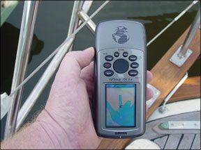
Garmin GPSMap 76CSx
During our 2006 test, we noted that the GPSMap 76CSx’s use of then new chip technology (SiRF) set it apart from the other units tested due to its rapid satellite acquisition. Our testers also noted that the software on the 76CSx was dramatically improved over the original 76 unit it replaced, providing full cartography capability using Garmin’s BlueChart imagery.
Brightness and contrast adjustment for the 76CSx are activated by quickly tapping the unit’s main power key, which introduces two slide bars on the unit’s display. You can then use the 76CSx’s “rocker” keypad to adjust the screen’s appearance. (Both the Colorado and Oregon also use this double tap of the power key for display view adjustments.)
Power is provided by two AA batteries, which (along with the Micro-SD slot) are contained within an O-ring-protected compartment, the cover of which is easily removed with a twist and tug of the locking pin. The 76CSx passed our dunk test with flying colors; it was also the only unit tested that floated. Battery life for the 76CSx during our test was 18 hours, the same as advertised by the manufacturer.
The Garmin 76CSx has a clearly marked, straightforward man overboard, “MOB” button, an important safety feature for a handheld GPS that is not offered by the newer units. Along with add-ons like an altimeter, stopwatch, and calculator, it also includes more cruising-oriented features like a digital compass, tidal calendar, and a lunar phase calendar. The trip computer page (showing selected data boxes such as course, heading, etc.) and display options cater to mariners who favor uncluttered screens with big numbers, although the instructions aren’t a great deal of help when it comes to using the advanced features. (Merely locating the tidal calendar requires some non-intuitive steps.)
Bottom line: The 76CSx still excels as a primary belowdecks position finder or as a handheld on-deck unit. Available for less than $240—a $300-plus drop from 2006—the 76CSx remains an attractive option that offers a number of features, but doesn’t overwhelm the user with add-ons the average sailor will likely never use. It also floats, a big plus that anyone who’s ever dropped gear overboard can attest
288
to. During side-by-side comparisons of the newer units, the screen of the 76CSx was not as clear, particularly at night when viewed at an angle.
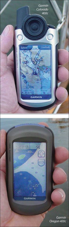
Garmin Colorado 400c
In January 2008, Garmin introduced the Colorado 400-series of handheld GPS units. The Colorado uses an innovative scroll wheel joystick (dubbed the Rock ’n Roller) flanked by two soft keys to control functions. It contains many of the features offered by the 76CSx (digital compass, altimeter, etc.) as well as some new ones, such as the ability to be paired with a heart-rate monitor and speed and cadence sensor for fitness use. The Colorado can also wirelessly share waypoints, routes, tracks, and geocaches with other Colorado GPS units. The Oregon also has this feature, and our two test units were able to exchange waypoints.
The Colorado uses a different GPS receiver instead of the SiRF receiver used in the 76CSx and the Oregon. Testers noted no significant lag in the time it took for the Colorado to get an accurate position after a cold start. The Colorado quickly locked on to satellite signals and maintained solid reception, even belowdecks in our test boats.
The Rock ’n Roller (touted as a major improvement over previous Garmin units) is designed for easy one-handed use, allowing users to navigate menus and lists with its thumb wheel. The Colorado is available in four different versions. Our test unit was the 400c, which is geared toward the marine market and comes pre-loaded with coastal charts for the U.S. and Bahamas, as well as the World Base Map that comes with all versions. All of the Colorado models can be upgraded to use additional charts.
The Colorado and Oregon sport a 240×400-pixel, 1.5-by-2.5-inch backlit color TFT display that occupies virtually all available surface area, making it the largest screen of any Garmin handheld GPS. Although clearly visible in the shade, good night viewing requires the backlighting, and it’s hard to see the screen from an angle in bright sunlight, even with full backlighting.
The pocket-sized Colorado was easy to grip and fit comfortably in the palm of our testers’ hands. It also comes with a carabineer clip that slides onto the mounting spine on the back of the unit, making it easy to clip onto a binnacle or clothing and backpacks for those bumpy dinghy rides and shore excursions.
An SD data card slot is located on the bottom of the unit and is accessible once the battery cover is removed. This arrangement also serves to protect the slot from water, dust, etc, during normal use.
The Colorado held up to drop tests without fail, and it passed the immersion test. Although the battery compartment and SD card slot are protected by O-rings, the battery cover design permits some moisture to enter along its outer edges, which are not gasketed. Also, the battery compartment O-ring tended to pinch when the cover was replaced (see photo, page 15), sometimes even becoming unseated.
Most Colorado features are accessed via the customizable Shortcuts menu, which can be pulled up by pressing the right soft key. Default settings in the Shortcuts menu include map, compass, mark a waypoint, and other features based on the selected profile. You can add or delete shortcuts so that your favorite functions, such as “Route Planning,” can be quickly accessible. This is similar to the “Pages” menu in the 76CSx.
Selecting “Profiles” allows users to customize settings for the various functions the Colorado offers. The unit comes with five preloaded profiles: Marine, Recreational, Geocaching, Automotive, and Fitness.
The Marine profile mirrors that of the 76CSx and adds a “Chart” function, which lets
154
you customize chart views (hiding or showing certain chart details, for example). The GPSMap 76CSx offers a much wider variety of custom chart views and palettes, with a menu page reached directly from the chart page.
Cruising sailors will appreciate how much easier it is to name new waypoints or edit old ones using the scroll wheel, but the simplified interface eliminates some desirable advanced features like the ability to customize the display color palette, add more than two data fields to the map display, and access tide forecasts. Testers could find no easy way to rename an existing route, something that is straightforward with the GPSMap 76CSx.
Bottom line: Testers liked the Colorado’s one-handed operation, expanded memory, big screen, and pre-installed charts, but for sailors who don’t need more than one chart kit, the 76CSx is a more cost-effective choice with more practical features. Among the Colorado’s shortcomings were its relatively dark screen, lack of a dedicated MOB button, and a back cover design that seemed vulnerable to water intrusion over time.
Oregon 400c
The Oregon 400 series is Garmin’s first foray into touchscreen handhelds. The 400 series comes in three models (the 400t, 400c, 400i), which are the same from a hardware standpoint, with the pre-loaded maps making the difference. Our test unit was the 400c, which comes pre-loaded with BlueChart g2 coastal charts and a worldwide basemap with imagery. (The 400i comes with U.S. Inland Lakes.) It provides essentially the same extra non-marine features offered by the Colorado.
Our testers used the screen in simulated rain, with sweaty fingers, and even while holding the unit underwater. It worked flawlessly. Testers were divided over the advantages of the touchscreen. Some found the software very intuitive and easy to use; others had trouble adapting. They noted that not every finger tap or drag (to scroll the chart, for example) produced the desired response. All agreed that Oregon’s touchscreen keyboard greatly simplified naming waypoints.
The Oregon uses the same size backlit color TFT display as the Colorado, and it suffered the same visibility problems. The screen itself was more reflective than the Colorado or 76CSx. Unlike many touchscreen devices, visibility is not impeded by polarized glasses.
Our testers found the Oregon well made and comfortable to hold. It has no protruding antenna, making it even easier to pocket than the Colorado. It also comes with a carabiner clip slide assembly.
During our battery test, the Oregon managed 16.5 hours of run time, which corroborated the “up to 16 hours” claimed by the manufacturer. It also passed our dunk test with no problem.
For waypoint entry, simply tap the map and a big red “pushpin” icon appears on the screen, along with two data-boxes showing distance from your position, heading info, latitude and longitude data, or whatever data you’ve chosen for the two boxes on the map page. For increased accuracy, you can also drag the map underneath the pin (the map moves, not the pushpin) allowing you to fine tune the location of the point selected.
Tapping the dialog box allows you to go to the waypoint or save it. While the ABC keyboard makes naming a waypoint fast, accessing the page where you can rename a waypoint is slow compared to the other two units. Renaming routes is equally convoluted. And unlike either of the other units, the Oregon offers no option to limit the number of databoxes on the trip computer (see photo, page 15), so that key data would be highly visible from a distance.
Bottom line: Rugged and simple, the Oregon is a cool tool that will no doubt pave the way for more sophisticated and impressive touchscreen handhelds. The software is still being refined, and our testers noted that the “no-button” approach to interface has its drawbacks. If you are naming and inputting a large number of waypoints, the Oregon will make your life easier. And the touchscreen eliminates potential failure points of mechanical buttons and wheels. However, like the Colorado, several advanced features get lost in the process of simplification. The lack of a dedicated MOB button and other key marine-oriented features (seeking future tides by date was not possible) also hold it back. It also does not allow for an optional external antenna, important for many sailors.
Conclusion
In Practical Sailor opinion, none of these units can be safely as a chartplotter. The screens are simply too small and the detail too hard to discern to serve as a primary plotting aid.
Although older, the Garmin 76CSx remains an excellent performer with memory-expansion capability that puts it on par with both of the newer units. Ease of use, performance, longer battery life, and a relatively inexpensive purchase price make it the Practical Sailor Best Choice, but don’t forget to factor in the cost of charts.
For those who are looking for a versatile biking-climbing-jogging-skydiving-automobiling GPS, the Colorado will fit the bill, and we expect prices to drop. It also retains some functions (extra-large databoxes) that sailors will like and are not found on the Oregon. Its shorter battery life and lack of screen options are drawbacks.
The Oregon represents the latest and greatest handheld, and if gadgetry is your thing, you’ll be happy with it. If the touchscreen holds up like Garmin expects it to, ruggedness is also a plus. Nevertheless, the move to touchscreen has stripped out some of the features that are important to sailors.
Readers should be aware that Garmin’s software updates are fast addressing many of the issues Practical Sailor raises (tide tables, display options, etc.), so check for new releases. However, until the functions of the Oregon or Colorado better reflect a mariner’s priorities, we’d stick with the older, cheaper—but admittedly less sexy—Garmin 76CSx. In fact, many of the even cheaper, non-plotting handle the mariner’s essential needs just fine, as well.


