


Sailors who are looking for a chartplotter, who tend to stray from the beaten path, or who spend a fair amount of time fishing may want to consider a combination chartplotter-fishfinder. These units offer a glimpse of the bottom’s contours, rather than just a digital depth readout. Often, the multi-function displays can also be linked to a radar, satellite weather receiver, or Automatic Identification Systems (AIS).
In our last look at 5-inch chartplotter-fishfinder combos (October 2008), the Garmin 545s was named Best Choice. Its integrated sounder and high-resolution screen boosted it above the rest of the field.
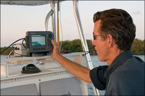
Photos by Al Herum
288
Since then, UK-based Raymarine has released a new A-series line. Its new A50D is comparable to the past winner, so we decided to see how it stacks up against the Garmin in a small plotter-sounder face off.
How We Tested
Just as we did with the field of 5-inch chartplotter combos we reported on in the 2008 issue, we ran the A50D through a series of sea trials, including day and night viewability tests and an evaluation of chartplotting functions.
The display was rated under a variety of lighting conditions, and the screen was viewed from varying angles, with and without polarized glasses and using both day and night color palettes.
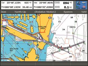
Chartplotter functions were evaluated for user-interface using various operations like creating waypoints, building routes, changing chart ranges, varying the chart orientation, and the like. Intuitive software, easy data entry, and dedicated function keys improved a unit’s ratings. Testers used preloaded U.S. coastal cartography to evaluate the A50D.
The sounder was rated for both presentation and usage. Testers prefer a feature-rich unit that’s easy to use and adjust. To test, we deployed three ping-pong balls taped 6 feet apart on heavy monofilament line in 32 feet of water to serve as our sounder target. We did not test for maximum depth capability on any sounder.
Raymarine A50D
The compact A-series chartplotters from Raymarine can be purchased in three screen sizes, configured with or without an internal sounder, and with or without pre-loaded cartography. Our test unit, the A50D, shipped with an internal sounder and preloaded cartography.
All A-series units have an internal GPS receiver and can be hooked up to an optional external GPS antenna. At different times, we tested the A50D using the internal antenna and a Ray125 external sensor. Both worked well at plotting position accurately.
Power and NMEA 0183 data pass through a single cable that fastens to the back of the unit with a twist-lock connector. Two other cable connectors provide a
288
transducer hookup and a Raymarine SeaTalkng connection. SeaTalkng is an N2K-compliant network.
The A50D is capable of interfacing with any NMEA-compliant Class A or Class B AIS unit. AIS devices use VHF frequencies to transmit and/or receive data (ship’s name, location, etc.) about other ships operating in a limited VHF range. We used the A50D display to test West Marine’s AIS1000. Look for details on this evaluation in an upcoming issue.
The Raymarine A50D that we tested had preloaded U.S. coastal cartography covering both mainland coasts and the Great Lakes. You can also get an A-series unit with no preloaded charts or with world coverage. All units can also use Navionics Gold or Platinum cards.
The high-resolution Raymarine display has razor-sharp details and is clearly readable. However the screen is not quite as bright as others we’ve tested. When viewed straight on with polarized glasses, the screen darkens some. Viewed from side angles, the screen darkens significantly and looks blank if the viewer is wearing polarized sunglasses. Testers noted a small amount of screen reflectivity but no fogging.
The A50D has two screen palette settings for viewing the chart page: day and night. Brightness in both day and night mode is infinitely adjustable using a slider or arrow keys. The night mode dims the unit significantly, and unless it’s viewed from straight on, it tends to lose colorization in night mode.
Soft key functions are page dependent with onscreen labels above each key. The unit can show full screen views of the chart page, fishfinder, course deviation indicator with data, and 3D chart data, if available. It can also display split views with two, three, or four windows. Users can press “Active” to toggle between open windows.
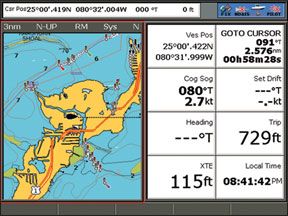
Data boxes can be displayed in normal or large size on the chart page. Normal has minimal information, but the large mode shows cursor position, course/distance to waypoint, vessel position, course over ground, and speed over ground. Map detail can be set to automatic or adjusted to different levels by the user, and a declutter key removes significant detail.
The MOB soft key doubles as the Waypoints key on the A50D. While the gray key is clearly marked—WPTS MOB—testers would prefer that it stand out more from the other function keys.
Pressing the MOB key puts the unit in man overboard mode. An audible alarm sounds, and if the unit is on a chart page, the view automatically zooms into the MOB position. If it’s not on a chart page, navigation data back to the MOB will be displayed in data boxes only. A second press of the key takes the unit out of the MOB mode.
Testers found creating waypoints, navigating to waypoints, and building a route functions to be easy and intuitive with the A50D. To create a waypoint press the waypoints function key; one soft key lets you place the waypoint at the cursor position, another does it at the vessel position, and a third by inputting latitude/longitude. A double press of the waypoints key is a shortcut to create a waypoint at the vessel position.
To navigate to a waypoint, users simply select it from the chart or off a waypoints list and hit Go To. This puts data boxes up with course and distance to the point, plus shows a course line to follow on the chart page.
To build a route, users simply press the navigation options key, choose routes, and
288
build a new route, then use the cursor to place waypoints on the chart.
Screen redraws on the A50D took several seconds when changing the range several steps at once. Ranging out always took longer than ranging in.
All chart orientations—heading up, north up, and course up—on the A50D worked very well, and the unit responded notably fast when making turns in the heading up and course up modes.
From the chart page, users can access additional information. Placing the cursor over a service icon then hitting OK will bring up data on the facility, and tide information can be found in the same manner or can be searched for by proximity to the vessel.
Sonar can be viewed full screen or in a variety of user-selectable preset split-screen modes.
The A50D internal sounder can put out up to 500 watts of power, compared to the 500 or 1,000 watts the Garmin is capable of putting out. The A50D is the most advanced fishfinder Raymarine offers, and it has many advanced features, including zoom; dual-frequency capability, which allows you to optimize the system according to the conditions and your needs; A-scope, the realtime display of what the transducer is seeing; shift, which allows for better onscreen interpretation; and bottom lock, which keeps the view focused on the bottom, allowing the user to better determine bottom composition. (For more on these features, see the online version of this review at
www.practical-sailor.com.)
Commonly changed sounder settings like gain, depth, and zoom mode are handled using soft keys. Pressing the menu button while on an active sounder page will bring up the fishfinder menu. The A50D fishfinder has a long list of useful features. We found it easy to operate and gave it a Good rating for usage.
We tested the A50D with a transom-mounted transducer, the Raymarine P58. The through-hull mounted transducer runs about $236 on its own, but likely would add about $50-$100 to the package price if purchased as part of a bundle or as an add-on.
During our testing, we had to make a perfect pass over our three submerged targets for this unit to mark them, still it sometimes failed to paint the deeper two. Increasing the gain manually helped some. The unit appeared to do a fine job painting bottom contours and a few large fish that swam under the test boat. We rated the sounder Good for presentation.
One drawback of the A50D that testers noted was its supplied mounting bracket. The beefy, swiveling bracket uses a single lever to lock the unit tilt angle. Tilt angle is preset to several positions, and none worked well for our test setup. Testers prefer infinitely adjustable mounts, which give users much more freedom as to where and how they want to install the device. Hardware for flush-mounting is also supplied.
Unlike the Best Choice Garmin 545s, which is submersible, the A50D is rated waterproof against sprays from powerful jets. We recommend mounting it out of direct rain or a drenching spray.
Bottom Line
Our top pick in the last go-round, the Garmin 545s, had across-the-board Excellent ratings for viewability, Good ratings for plotter and sounder user-interface, and Good ratings for sounder presentation. In comparison, the Raymarine A50D bested the Garmin for plotter user-interface and matched it with Good sounder ratings, but fell short on viewability.
Both feature internal sounders. This simplifies the installation and saves on space. The Raymarine A50D was the only unit to offer a two-year warranty.
In our opinion, the Raymarine A50D is a quality chartplotter and decent sounder, but it failed to beat out the Garmin for the top spot. It deserves consideration for those who prefer, or already have, Navionics cartography and want a plotter-sounder that can interface with an AIS.


