

Photos courtesy of Andren; bottom photo by Bill Bishop
Not long ago, one of our marine electronics testers, Bill Bishop, was faced with the task of transferring the waypoints from an ancient Garmin 215 chartplotter to a newly installed Garmin 7215. There are several ways to do this, but Bishop found that one of the most convenient ways to transfer waypoints was using Andren software on a PC computer. The software is so versatile that it even can be used to transfer the waypoints from an old Loran receiver (remember those?) to a new GPS.
There are two paths you can take when migrating waypoints from one system to another. The first involves doing the conversion with Andren and loading the waypoints into the new system using data cards. If data cards and readers are no longer available for your older system, you can usually download the waypoints using the chartplotters NMEA 0183 outputs.
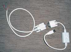
To carry out an NMEA transfer, you need a good quality USB-to-serial adapter and a serial data cable with the critical wires stripped and identified. In this case, the red serial cable wire is the receive data (pin 2), the orange wire is send data (pin 3), and the green wire is data ground (pin 5). Once the wires have been identified, you interface them to the corresponding wires on your chartplotter. You also will need a power supply to run the GPS.
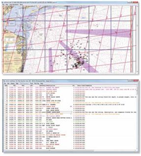
With the wiring completed, and the old chartplotter (Garmin 215, in this case) set to Data Transfer, you simply go to the Andren Tools menu, select Upload Download GPS, and select Garmin. A little window pops open. You click Get Waypoints, and the PC does just that, again and again. All of the waypoint data is then put into a spreadsheet-like format on the PC.
Andren gives you a wide range of options for importing this data-Furuno, Garmin, Maptech, Northstar, Raymarine (by series), Simrad, GPX, etc. If you can save the old data on a card that is supported by the new device-meaning you have a card reader for it-the conversion process is pretty straightforward: Import the file, fix it if needed, and then export the file in the desired format.
There is some nuance to the export-import process. In one conversion, Bishop had to cut 1,000 waypoints from 16 characters (which Raymarine allows) to 10 characters (the maximum for Garmin). The Andren software allows you to edit the names prior to exporting.
Andren converts time difference (TD) coordinates from old Lorans to latitude and longitude, and has the most complete set of waypoint conversion options available anywhere. Move Furuno waypoints into a Raymarine system. Take the Raymarine data, and use it in a Nobeltec system, and so on. You can also edit, organize, and print hard copy books containing your waypoint data. There also is a trip planner and a utility to create custom maps using the supplied NOAA BSB charts.
Bishop was able to take an antique Garmin unit, extract the waypoints using the NMEA interface, convert them to the Garmin userdata.adm format, and upload them to a new Garmin 7215, even changing the icons to the current Garmin format.
Another cool thing about Andren is that you can import waypoints saved in GPX format. This is effectively the waypoint standard used by everyone except mariners-although several PC-based marine navigation systems use GPX. Wed like to see more chartplotters accept GPX. Some do-to a degree-like Garmins Home Port, which will convert GPX to the userdata.adm format used by its marine chartplotters. There are tens of thousands of GPX waypoints available online, covering almost every imaginable point of interest. For example, say youre cruising, and you want to have local historical markers placed on your chartplotter. The Andren software can do this for you.
Bottom line: PS found the email tech support from Carl Andren to be very responsive. At $85, the software is a bargain for anyone facing a monumental waypoint transfer project.


