


We last covered color GPS chartplotters in the February 15, 2000 issue, almost an eon ago in the world of marine electronics. In that evaluation, the Si-Tex Nautilus was the Best Buy, and the Simrad Shipmate CE40 was our pick at the top of the line at $6,500.
As we noted even then, the basics of any GPS receiver—its ability to acquire and track satellites, and to perform accurately the trigonometric gymnastics that give us such functions as real-time position, course over the ground, course to steer, cross-track error, estimated time of arrival, and so on—can pretty much be taken for granted these days. We haven’t encountered any GPS device in years that couldn’t do those things almost flawlessly, no matter the manufacturer. The GPS constellation is full and robust, and the guts of these machines are proven.
Rather than split hairs on which plotter can acquire a signal fastest from a dead stop, we decided to focus on a few other factors that have a profound effect on whether a plotter becomes a trusted part of the navigator’s toolset, or just a fair-weather friend: daytime visibility, nighttime visibility, and the functional ease, or intuitiveness, if you will, of the user interface. Call it button ergonomics or programming logic, but let’s define user interface, at its most basic, as “what you push to get what you want.” To us, this means how easy it is to find current position, not only as a spot on the plotter screen, but as a numerical latitude and longitude (to plot manually on a paper chart if necessary), as well as course and speed over the bottom and course correction information. Finally, it means the ease of manually entering a latitude and longitude as a waypoint, and of accessing that waypoint later.
Those functions may seem obvious, but one thing we noticed when we last reviewed handheld GPS receivers with charting functions (December 1, 2001) was how difficult it was sometimes to get to those basics . And the reason is that those handhelds are no longer dedicated primarily to the mariner. They are dedicated primarily to the motorist, to whom latitude and longitude are about as useful as teats on a bull.
If the functions we’ve mentioned above are the essentials, then much of the other software engineering on GPS receivers these days is icing on the cake, and the trouble now tends to be a surfeit of icing. Access to the main functions should be easy and logical, but today basic access is almost a negotiated affair between the programmer and the user, with the marketer in between as a broker. The importance of various functions varies from user to user, and the programmer functions at the behest of the marketer, whose job it is to make the product applicable to as wide a range of customers as conceivable. Thus, the product gets loaded with so many features, so widely spread, thinly reinforced, and complicated to access, that no market segment gets a full plate of what it needs.
It was our hope that these plotters would be dedicated more to the mariner again, and in fact we weren’t too disappointed on this score. The motorist stuff is still there in many places, but the cartography that can be displayed and manipulated on these plotters puts the handhelds to shame (even though much of it is the same cartography). The screens and the navigation buttons are that much more evident, logical, and robust.
All of the plotters in this review use vector cartography. (There are a few plotters available that can use raster cartography, notably the Northstar 962, which has 256 megabytes of resident memory, can accept uploads from Maptech CDs, and costs $11,495.) The choices of vector-based charts for these units are from C-Map, Navionics, and Garmin’s MapSource BlueCharts, which are proprietary to Garmin.
Si-Tex Nautilus NT iGPS
The Si-Tex has an all-plastic case and simple panel layout. Two C-Map NT chips can be inserted underneath the main body and protected with a rubber plug/cap. It has a large, red power key (which also controls screen brightness), and next to it the MOB button. Below those are the Menu, Clear, and Enter keys. The Enter key is a quick thumb-move away from the four-way cursor pad. Below the screen are four soft keys that are screen-context sensitive.
The Si-Tex buttons are well laid-out and quite intuitive. They will be relatively easy to operate underway, since you can grip the lower right corner of the box and do most of what you need to do with your right thumb.
We miss the alphanumeric keypads featured on four of the largest machines, but the toggling works predictably here (at least for us). Programming, naming, and editing waypoints is tedious, and best done in a quiet harbor. This is true of all the “toggle/select/enter” interfaces on the smaller machines. At least the ways of the Si-Tex are not mysterious.
We were interested to note how different the C-Map NT chart looks on the Si-Tex machine than it does on a “higher-end” machine like the Raymarine. Because of the lower pixel count (320×240 versus 640×480) the whole texture of the chart is coarser at all levels of detail. We question, however, whether this makes much of a difference at any of the screen sizes and resolutions we’re dealing with here. As with all chartplotters, you feel as if you’re observing the chart through a keyhole.
Bottom line: Our testers bonded with this simple, bright, easy-to-use Si-Tex, especially in the direct sunlight and user-interface evaluations. It was a toss-up for Best Buy between this machine and the Standard Horizon CP150C, which costs $90 less.
Raymarine SL 530
This unit houses two C-MAP NT cartridges behind a well-gasketed door on the left side of the display. The red power button is below, in the corner. Four large soft keys, sensitive to screen context, live below the display. On the right-hand side of the box, from top to bottom, are dedicated keys for Gain, Display, VRM/EBL (used to measure range and bearing between two points), Marks (doubling as the MOB key) and Multi (which also controls screen brightness). Below those you have a button for Alarms and a Range rocker/toggle for zooming in and out, then the cursor pad, and finally buttons for Enter, Clear, and Menu.
The Raymarine displays the charts crisply and brightly with a screen resolution of 640×480. The difference between the Si-Tex display and Raymarine display of the same area is distinctly to Raymarine’s advantage in terms of clarity and smoothness.
We found the Raymarine’s user interface fairly complicated, and often had to refer to the manual to get the hang of things. While many functions follow a pattern familiar for all electronics, others do not. For example, several of the dedicated buttons have press-and-hold functions in addition to the regular momentary push functions. It was difficult to remember whether pushing the up arrow on the Range rocker meant zooming in or out. (It means zoom out.)
The Range rocker and Enter, Clear and Menu buttons are organized within easy reach of the thumb from the cursor pad, although we might quibble that Enter should be in the lower right corner where Menu is. The acronyms on the VRM/EBL button stand for Variable Range Marker and Electronic Bearing Line; they’re really radar terms that can work in this context, except that they sound a bit busy. Range and Bearing would do fine, but then we suppose the Range rocker would have to be renamed Zoom In and Zoom Out. In any case, once you get used to it all, you’ll understand the interface on several other Raymarine products. Those thinking of installing a whole Raymarine package will do well to practice with the peculiarities of the interface and acronyms.
Bottom Line: It has an excellent display, although not as easy to read in the bright sun as we’d like. The controls take getting used to. If we were going with an integrated Raymarine system, linked with that company’s proprietary SeaTalk, we’d strongly consider buying this. As a stand-alone plotter, it’s outclassed, in our opinion, by the Simrad.
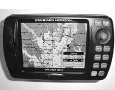
Standard Horizon CP170C
Like its smaller sibling evaluated next, the CP150C, the CP170C has an excellent display, very bright and evenly lit, with good contrast. It has two slots for C-Map NT cards behind a door on the left-hand side. The door has a good positive catch, and there’s a capable gasket around the slots. There are five soft keys below the display, and on the right-hand side of the box are 10 more dedicated buttons for standard functions like Enter, Clear, GoTo, Menu, Mark, and Route. The red power button and red-lettered MOB button are the two bottom buttons.
The distinguishing control of both the 170C and 150C is the so-called ShuttlePoint knob, which is actually a stubby joystick worked by the thumb with the fingers curled around the right-hand side of the box for stability. (The nipple theme would work here, too, but we’ve used it already.) The ShuttlePoint is, for us, more effective than the cursor pads used on all the other plotters reviewed here, as well as the circular hybrid tool used on the Simrad GP33, which has its own system (discussed later). It works about the same as the cursor pads for moving around on the chart, but where it shines is in the toggle/select mode, as when you’re entering and naming waypoints. Here it has a distinct advantage, both in speed and intuitive function.
The only thing we worry about is the ShuttlePoint’s longevity. There was a sensitivity difference between the pointers on the 170C and 150C—neither positive nor negative, but the difference gave us the impression that the contacts under the rubber might be sensitive enough to become fragile after a certain number of hard knocks out in the elements.
Bottom Line: The CP170C performs well, and is easy to learn. The zoom buttons, Enter, and Clear are all grouped logically around the ShuttlePoint. The manual is concise and clear. The buttons are not backlit, strictly speaking, but have a slight loom of light around their edges that makes their lettering visible in the darkness. Some people will complain that they’re not bright enough; others will praise them for preserving their night vision.
We can easily recommend this unit.
Standard Horizon CP150C
Most of the comments on the CP170C above also apply to this smaller unit. The button navigation, centered around the ShuttlePoint joystick, works almost the same. The main difference is that the 150C has no soft keys—everything is done with the joystick nub and Enter key. For instance, if you want to enter a waypoint, you push Mark, then Enter, then choose Edit, then change the coordinates with the joystick. The other difference is that the 150C holds only one C-Map chip instead of two. The display is just as good, if not, for some reason, slightly better than that on the 170C.
The CP150C is physically the smallest unit we looked at, but it’s handsome, easy to operate, and performs well.
Bottom line: We saw no disadvantage to the lack of soft keys here; in fact chores like entering waypoints manually were just as simple using only the ShuttlePoint and Enter key.
Like the 170C, it has “side-lit” buttons whose functions are visible enough at night, but not very strong.
This would be an excellent choice for a smaller boat with limited instrumentation space—or, for that matter, on a larger boat whose owner doesn’t care for a lot of in-your-face electronics. It also sports the lowest price of the batch. All these things combine to earn the CP150C a Best Buy, in our book.
Garmin GPSMap 2006C
The 2006C can take two data chips behind a door on the left-hand side. You’ll want Garmin’s proprietary BlueChart data, which you can get on pre-written chips, or write to blank chips from a MapSource CD. The door is well gasketed and has a positive catch.
The Power and Zoom buttons are in the upper right-hand corner; the other navigation buttons (Page, Quit, Enter, Menu, and Nav) are thoughtfully arranged in a crescent around the left side of the cursor pad, so that most everything can be done with one thumb. Five soft keys, sensitive to screen context, are under the display.
We found the 2006C interface very intuitive, with no need to refer to the manual. This is the first unit mentioned here with an alphanumeric keypad, and what a difference it makes for entering waypoint names and data —it cuts data entry to about a quarter of the time it takes with the toggle/enter method, and will be much preferred if you have a lot of information to enter or edit. It’s also easier to work in a bouncy environment. The trade-offs, of course, are the larger surface space required for the keys, more moving parts, and increased possibility of water getting inside.
Bottom line: For a stand-alone plotter, this is a top contender, mainly because the interface is so good. It could have done better in the tests for visibility in sunlight, but it did well enough. The BlueChart look and feel is, in our view, more natural (meaning closer to NOAA charts) and therefore easier to grasp quickly than C-Map NT+ and Navionics cartography—although we can’t speak for the accuracy of the data in any of these cases. This opinion is probably related to the fact that we’re used to navigating with government charts and can recognize things on them at a glance. BlueChart cartography supports that habit, while the other vector cartography makes you learn anew. Not always a bad thing.
Garmin GPSMap 182C
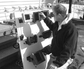
This unit was the only one in this review with a self-contained GPS antenna. When we mounted all the plotters on a board, we unthinkingly put the 182C down low, so that its antenna was at a disadvantage compared to the others, which were mounted in a row on a plank at the top of the mounting board. When we took the whole board outside for a fire-up satellite gathering and bright sunlight evaluation, we were going to move the 182C up to the top row, but just for kicks fired it up along with the rest, right where it was. It turned out to be among the fastest to acquire a position from an uninitialized start. Pretty impressive.
We particularly like the dedicated Page button on both Garmin units. This lets you leaf directly from the chart view to other pages of valuable and semi-customizable information, and back again to the chart, in full screen, with one series of pushes.
The 182C takes one BlueChart data chip, which is inserted upwards, vertically, behind a flip-up plastic hatch in the lower right-hand corner of the set. The lower lip of the set-up has a minimal gasket, but the edges don’t. It would be difficult for water to find its way to the chip, although we suspect some might flow past it inside the edges of the little hatch.
The 182C lacks the alphanumeric keypad and soft keys of the 2006C, but navigation functions follow Garmin’s programming logic, and are quite easy to grasp. One motif used by Garmin programmers is the familiar file-folder tabs graphics used by Windows and Visual Basic programmers. It works. No need to riffle through the manual.
Bottom line: We’d recommend this plotter for smaller boats and open nav stations, if you want both the display and the antenna together. Like the bigger 2006C, it can exhibit the Garmin BlueChart data. It also has strongly backlit buttons, and would make a good choice for night use.
Navman Tracker
We’ve been discussing gear made in New Zealand quite a bit in these pages recently. One of the equipment lines making itself felt is the Navman series of instruments, so we were glad to include the Tracker in this review.
The Tracker accepts one C-Map data chip, which is inserted into a rubber holder. This, in turn, is plugged tightly into the right side of the unit in what is probably the most watertight arrangement of all the plotters reviewed here.
Buttons are sparse on the Tracker: Escape, Display, Menu, and Enter form a semi-circle around the right side of the cursor pad. Below that are dedicated buttons for Zoom In/Out, Waypoint setting, MOB, and Power. That’s it. Most functions have to be accessed via the Menu button. It’s not fast, but once you get used to going to the Windows-type Menu functions for most everything, it’s consistent. The dedicated Waypoint key is a good feature.
Our only real disappointment stems from the lack of daytime visibility. The machine just wasn’t in the same ballpark as the others during the bright sun evaluation, although it’s fine in the shade or in the dark.
Bottom line: The Navman tracker seems quite waterproof and rugged. Its functions are a bit difficult to toggle through, but no more so than on other machines without alphanumeric keypads. Its backlit buttons make it one of the best in this test for night use. If you can use the machine out of direct sunlight, it’s pretty solid choice for $940.
Simrad CP33
This is the younger cousin of the very powerful Simrad Shipmate CE40 that trounced the heap for sheer power and functions last time around (at $6,500).
The CP33 ($1,350) takes one C-Map chip in a spring-loaded pop-out drawer. The inside lip of this drawer has a thin gasket, but the way it locks into the housing doesn’t convince us that it’s making solid contact with that gasket. We also found that when we pushed the release button hard, the whole drawer would fly right out of the box. If we had one of these out in the elements a lot, we’d be tempted to help seal the edges of the drawer with tape or a thin bead of removable sealant.
As a medium-large (or light-heavyweight) unit, the CP33 manages to encompass a full alphanumeric keypad in a relatively compact face area. To the left of those keys is a column of dedicated buttons for Chart (which toggles back to the current chart from any other display), Echo (to report depth and water temperature from a linked sounder), Pilot (which toggles between various highway views), and Page (which pages through four pre-selected displays).
Vessel position underway is shown by a circle with a heading vector line extending from it.
The main user navigation is done with the right thumb on a very clever toolset in the upper right-hand corner of the box. A silver directional pad is surrounded with the most frequently used buttons in a logical sequence—Menu and Enter at left and right on top, Zoom buttons on the sides, and GoTo and Plot left and right on the bottom.
Note that we said “directional pad” instead of “cursor pad” in this case, because the CP33, alone among all these plotters, uses full-screen crosshairs, not a small cursor, as the default pinpoint locator. This is the wisest orientation indicator on small, cluttered screens, in our opinion—crosshairs make it much easier to move the focus quickly and accurately at any zoom level.
The pad itself is gratifyingly sensitive to thumb vectors (thumb vectors?) between the vertical and horizontal axes. Data entry is easy, although it requires a bit too much hand movement when you have to advance to the next letter by pushing the right side of the pad. You can advance letters using the zoom buttons, too, but that negates the usefulness of the keypad.
Bottom Line: Chip drawer concerns notwithstanding, this is an attractive, easy-to-operate unit, with good screen performance in daylight and at night, with its backlit buttons. It will be among the best in rough conditions, because of the crosshairs. Highly recommended.
Northstar 952X
The 952X is one of the bigger and more expensive units in the evaluation ($2,550). It takes a single Navionics cartridge (we used one for the Great Lakes), and locks it behind a strong gasketed hatch that can actually be dogged down with the twist of a ring. The unit has an alphanumeric keypad underneath a four-way cursor pad. Clear and Enter buttons straddle the zero key. The cursor itself is a small gunsight ring with moving red reference arrows that track the position of the cursor from the edges of the screen, making it easy to keep track of things in the clutter.
On the left side of the screen are the power button, a rocker to control screen lighting (the only such dedicated rocker in the evaluation, and most welcome), and a Save button that doubles as the MOB button. Underneath the screen are buttons that give immediate access to position, steering functions like cross-track error and ETA, waypoint and route access, and navigation plan progress and settings. The key in the middle simply has a star graphic on it. It allows you to check alarm conditions and tides, and to customize other settings.
To the right of the screen are five soft keys that apply to screen context. These soft keys get more work than the ones on other units, handling zoom functions and providing toggles to more specific controls. There’s no dedicated Menu button on the box, which is a bit disconcerting at first, and while learning the machine you find no familiar Windows-type pull-down menus or Visual Basic-type clickable tabs. This is an example of a user interface that, while certainly learnable and workable, seems behind the times to us when it comes to providing familiar, easily negotiated function controls. We had to refer to the manual to get to know the machine, and a couple of times had to back out of a process when we tried various methods of doing things that just didn’t match the intentions of the programmer.
The chart scrolling, chart clarity, and zoom functions on this unit are excellent, in the same league as the Raymarine and Furuno, and the Navionics cartography functioned well.
Bottom line: We like the box and have no strong objection to the ergonomics of the keypad, buttons, and cursor pad, except that the Enter button should be in the upper right-hand corner along with the cursor pad. It was easy to set and name waypoints, and the soft keys work well for major functions. However, we’d like to see more familiar software controls behind the screen, particularly if we need to go without a dedicated Menu button. While the display has a number of good adjustments, including a Hi-Brite setting for optimum viewing in sunlight, the keys and buttons on the unit are not backlit.
In this higher price range, we prefer the ergonomics of the Garmin or the Raymarine. This is a subjective matter—there’s still a lot to like about the Northstar.
Furuno GP1850W
This Furuno, one of the larger units tested, hosts a single large-format C-Map NT card (called an FP Card) behind a flip-down door in the lower right corner of the box. The card is protected by a positive gasket on the door. The controls follow the familiar pattern: cursor pad in the upper right corner with Enter and Save/MOB to the left. Below is a full alphanumeric keypad, with Clear and Menu either side of the zero. There are five soft keys on the right side of the screen, and dedicated buttons for Alarm, Plot (toggles between chart and nav data), XTE/HIWAY (shows cross-track error and various steering views), and Hide/Show (toggles the soft key menus on and off). Zoom functions are handled by the top two soft keys, as on the Northstar.
We found the Furuno’s user interface intuitive and easy to use. We didn’t need to consult the manual, and didn’t get stuck wondering which way to go with the buttons. Entering and naming waypoints is easy, especially with the keypad. The screen display is crisp and smooth, and the brightness and contrast settings effective (although oddly named, we thought, Brill and Tone, like something out of a Harry Potter story).
Cursor pad scrolling seemed a bit jumpy to us, when going for fine-control details like centering over a mark, but it was fast when you put the pedal down to go across a bay or harbor. The screen redraw rate after zooms and pans was quite slow, especially for a high-end unit like this.
While we didn’t need to use the operator’s manual, we did have a look at it. It’s short on gloss but long on quality and clarity. It carries, for example, a full two-page menu tree showing all the submenus and pull-downs, with their defaults in bold. This is truly handy.
Bottom Line: Most Furuno hardware is built tough, and this plotter seems to fit the mold well. There’s nothing too racy or unexpected about it, but it performs all functions adequately, some very well, and probably with good reliability over the long term.
We would wish for a cursor pad that was a bit more sensitive, and for faster screen redraws. Otherwise it’s easy to recommend this machine, especially for the $1,300 price.
Conclusions
In the smaller range it’s a bit of a toss-up, but we’d go with the Standard Horizon 150C. It’s a handsome, easy-to-run unit at a nice price. The Si-Tex Nautilus and Garmin 182C are also good choices.
Garmin’s BlueChart is, in our view, the best vector software, if only because things look more familiar.
For a stand-alone unit among the larger models, we’d take the Simrad CP33, with the Furuno as a solid second choice in the same price range.
Also With This Article
Click here to view “Daytime Outdoor Visibility.”
Click here to view “Value Guide: Color Chartplotters.”
Click here to view “Chart Chips.”


