There are lots of books and guides to help amateurs make their way along any portion or all of the famous Intracoastal Waterway (ICW). From time to time, Practical Sailor has gathered up such books, including charts kits, for comparison.
In hand is a new guide for part of the above-mentioned waterway. It covers the ICW from Hampton Roads, Virginia, to Biscayne Bay, Florida.
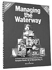
“Managing the Waterway” ($24.95), which the authors, Mark and Diana Doyle, call an “enriched cruising guide,” covers the section of the ICW that is most used, both by locals and passagemakers. It takes a somewhat different cut at the considerable effort that must be invested to make a successful trip on the ICW.
Featuring what the Doyles call “rolling headers,” each navigation page of the book contains well-organized mileage figures; weather contacts; tide times and ranges; hailing and working radio channels; U.S. Coast Guard telephone numbers; towing contacts; safety information; bridge openings; navigational hazards; security zones; marinas; nearest chandleries; and even landmarks. The detail is impressive. You’ll even know when you’re passing the Wappoo Creek Bridge (it’s between the southbound arm of Elliot Cut and the Charleston Coast Guard Station).
The information is presented on facing pages, with information that covers the distance (varying from about 150 to 300 miles) that a powerboat (not a sailboat) might make in a day on the ICW in that locale. The distances vary because of the waters and bridges involved, and are in statute miles. Because most boats have knotmeters, the Doyles’ book has, inside the back cover, a clever “Mixed Metric DST Table” that makes it easy to read off nautical/statute conversions for three different kinds of speed, time and distance problems. Catching the bridges right is an important part of ICW pilotage.
In addition to all the vital data for 283 anchorages; 349 marinas; 142 bridges and locks; 26 inlets; 443 GPS waypoints, and alternate routes, the Doyles have managed to squeeze in 260 vignettes about the history and wildlife for which the ICW is famous.
There also are more than 200 photos and illustrations, including several that one might do without (like one of Mel Gibson as “The Patriot,” and another showing Jimmy Buffet almost covered with parrots. These seem particularly extraneous given that some of the type used is a bit small for those with less than perfect vision.
“Managing the Waterway” measures 9″ x 11″ x .6″ thick, has 172 pages, a UV-coated cover and a lay-flat, double-wire binding. It came out in August and should now be in chandleries and bookstores that carry nautical books in case you want to pick it up and compare it with what you’ve been using.
Contact – Semi-Local Publications, 612/729-4411, www.managingthewaterway.com.


