


288
Ordinary depthsounders are suitable in most cruising areas, but for those less-traveled channels and anchorages, being able to actually see what’s under your keel can be a significant advantage. This is where fishfinders offer a navigational edge: They allow you to see seabottom contours—and fish, of course—rather than a simple spot reading for depth.
We last tested chartplotter-sounders in 2006. The Lowrance LMS-337CDF topped 4-inch units in “Small-screen Plotter-sounders” (April 2006), while the Navman Trackfish 6600 bested 6- to 7-inch combos in “Diving into Plotter-sounders” (June 2006).
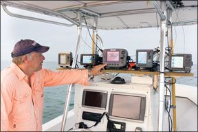
For this test, Practical Sailor’s goal was to test complete small-screen units capable of handling chartplotting duties on a detailed map and providing bottom contours on a single display screen. We took a look at five products with finely detailed chart pages using either internal maps or cartography on a card. All were outfitted with high-powered sounders.
What We Tested
To keep things economical, we chose units with 5-inch display screens. Total package pricing including display, sounder, transducer, and cartography was kept near the $1,000 mark.
Two units we tested, the Garmin 545s and Lowrance LMS-525C DF, include both a chartplotter and sounder in a single integrated housing. Our other three picks—Raymarine A60, SI-TEX Colormax 5E, and Standard Horizon CP180—use black-box sounders connected to the plotter display for fishfinder capabilities.
Some of the machines we tested are also capable of interfacing with radar, satellite weather receivers, and AIS units, but none is capable of displaying video. All are compatible to the older NMEA 0183 standard, but only the Lowrance is compatible with NMEA 2000. All have split screens that show two views at once, and all have one slot for map cards. None has an alphanumeric key pad.
The Garmin and Raymarine products were the only ones rated to the IPX7 standard, which means their components can withstand temporary submersion in water. All others were rated to handle powerful jetting water or were merely splashproof.
288
All of the sounders tested operate on two frequencies, 50 and 200 kHz; have auto depth ranging as well as auto and manual gain control; and give water temperature readings.
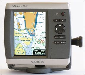
Garmin GPSMAP 545s
Garmin’s compact 500-series chartplotters offer a wide variety of configurations. Our test unit, the 545s, ships with an internal sounder, preloaded cartography, an internal GPS receiver, and internal antenna. (We used the optional external antenna for our testing.) Our test unit had Garmin’s BlueChart g2 U.S. Coastal cartography covering both mainland coasts from Canada to Mexico and the Bahamas, Puerto Rico, Hawaii, and Guam.
All 500-series units have 5-inch screens, and those designations ending with a “5”—like our 545s test unit—have 480 x 640-pixel screen resolution. All are capable of using Garmin BlueChart g2 Vision cards, which offer 3D views above and below the water as well as extensive satellite and aerial photo coverage.
Power and NMEA 0183 data pass through a single cable that fastens to the case back with a twist-lock connector. An additional leg on this cable connects the supplied transom-mount transducer. Flush-mounting requires an optional kit.
288
The viewability on the high-resolution, portrait-oriented Garmin screen was Excellent. Though it was not as bright as some others tested, its details are sharp and readable. Wearing polarized sunglasses and viewing the screen straight on, testers noted slight screen darkening.
The 545s has an automatic backlight control system that works via a sensor on the front of the display. We found it worked very well.
With a limited number of pushbuttons, onscreen menus lead the user through most functions, starting at the home page, where the user can select from six main pages: Chart, Sonar, Chart/Sonar, Where To, Information, and Configure.
To create a waypoint at the boat’s present position, you hit the “Mark” button. A menu allows users to edit, delete, select the point as a man-overboard (MOB) position, or go back to the chart page. To navigate to a waypoint, you first select it from the chart or off a waypoint list, then select the “Go To” function. This puts data boxes up with course and distance to the point, plus shows a course line to follow on the chart page. Route building is just as easy.
To initiate the MOB function, press “Mark,” select the MOB function, and confirm. The unit then creates a waypoint, switches to the chart page—if you’re not already on it—and opens data boxes giving navigation information back to the MOBposition. The Garmin MOB function is good, but we prefer to be able to activate it with only a single button push.
288
Garmin Senior Communications Manager Ted Gartner said the company will be improving the MOB function in a future software update so that pressing the “Mark” button twice activates the MOB function. According to Gartner, with the current software, the position is captured the first time the button is pushed, so there’s no delay in getting the right location locked into the machine.
Screen redraws on the 545s are fast under most circumstances and slowed only when we built a route that required map range changes.
Users can customize the sounder setup and how its data is displayed. The 545s internal sounder is capable of putting out 1,000 watts of power, and it has all the features you’d want in a fishfinder, including A-scope and bottom lock. (See “Buyer’s Guide,” for more on these features.) The only thing it lacks is a shift function.
During our testing, it marked all three submerged targets clearly, even with auto gain set. This fishfinder has plenty of features, was easy to operate, and worked well in all auto modes.
Bottom line: Razor-sharp screen details combine with high ratings to earn the Garmin 545s Best Choice.
288
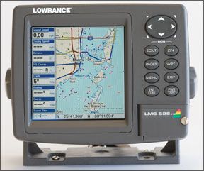
Lowrance LMS-525C DF
Lowrance, now under the Navico umbrella of marine electronics brands, packages the LMS-525C DF, a chartplotter and 500-watt dual- frequency fishfinder in one unit, with a transom-mount transducer and NMEA 2000 GPS sensor. This unit does have a built-in base map, however for detailed cartography, a map card is required.
We tested the unit without the map card. Other models of this machine are available with an internal antenna and/or a single frequency lower-power internal sounder.
Electrical connections are all made on the back panel with color-coded locking connectors. The LMS-525C is capable of interfacing with Lowrance radar. When installing this combo, you’ll need to provide power to the display unit and an NMEA 2000 network because the GPS sensor communicates with the display using this protocol. Flush-mounting requires an optional kit.
We rated the square Lowrance display screen Excellent for night and day viewability. It has three color palettes: normal, high contrast, and night. We found little difference between the normal and high contrast modes for day. The screen provides a clean, sharp picture, but darkened slightly when viewed at steep angles or from straight on with polarized sunglasses.
Frequently used functions like waypoint and pages have dedicated function keys, a feature testers liked. Other options are carried out by selecting the appropriate menu.
288
A waypoint can be created by pressing the “Wpt” key twice. If the cursor has been moved off the boat position, a waypoint will be created there, otherwise it will be created at the boat’s present position.
To build a route, we selected the “Route Planning” page from the navigation menu. There, you can name the route and add legs. Testers found it an easy procedure.
To activate the MOB function, press the “Zoom In” and “Zoom Out” pushbuttons simultaneously. Once an MOB waypoint is created, the unit switches to a compass-rose plus data-box display, providing navigation information to the MOB point. We like the single-step MOB activation, but testers did not like being taken off the chart page.
Screen redraws on the Lowrance were lightning fast with the base map. However, with a chart card installed, we’d expect updates to take a bit longer.
We reviewed the sonar features using a full-screen display with A-scope turned on. Another useful display option is split screen with low frequency on one side and high frequency on the other. This unit has a 500-watt sounder built in with zoom capability but no bottom lock or shift.
288
With the Lowrance set to auto gain for the sounder testing, it marked lots of noise and all three submerged targets. When we manually lowered the gain, we got a sharp fix on our targets. The Lowrance fishfinder was fairly easy to operate and worked well.
Bottom line: The Lowrance performed very well and we like that it uses Navionics cartography. With a price tag $200 below most others, it gets the Budget Buy rating.
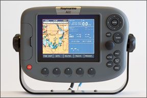
Raymarine A60
Raymarine’s system ships with the A60 landscape-oriented display unit, a DSM25 black-box sounder, the RS12 GPS sensor, and a map card.
An important note about the RS12 GPS sensor: Satellite changes made last year have rendered the sensor incapable of receiving WAAS signals. It remains fully functional as a GPS receiver, but lacks the additional WAAS accuracy. Upgrading to the Raymarine RS125 GPS sensor costs approximately $300 and restores WAAS capability to the A60.
The Raymarine comes with Navionics Silver All-in-One cartography, which has rated highly in previous testing. Connections for power, GPS sensor, transducer, and NMEA 0183 data are through twist-lock connectors on the back panel. With the rear panel bezel removed, the A60 can be flush-mounted.
Chart redraws on the A60 were comparatively slow: It took as long as five seconds to fully redraw all data after a long-range change.
288
The A60 had the largest screen in our test group, but with a 320-x-240-pixel resolution, it had the fewest pixels per square inch of screen. This made fine details hard to read. Sunlight visibility was also hindered by a lack of selectable color palettes, high screen reflectivity, and less screen brightness than some of the others.
The A60 screen darkened when viewed from side angles, gradually getting worse as the angle increased, earning it a Fair for day viewability. We rated the Raymarine A60 Good for night viewability as the standard color palette seems to be better for night viewing than day.
288
Dedicated pushbuttons for page selection and waypoint functions plus five soft keys with page-specific functionality earned the Raymarine A60 an Excellent for chartplotter user interface.
A present-position waypoint is saved with two pushes of “Wpts/MOB.” Pushing it once, then pressing a soft key saves the position at the cursor, vessel, or present position. Navigating to a displayed waypoint is a simple matter of placing the cursor over the point, then hitting the “Go to Waypoint” soft key—easy and intuitive in our opinion.
Route construction was also easy: Press the “Route” soft key, then “New Route,” move the cursor, and press “Add Waypoint” for each point in the route. When done, press “Save Route.” That’s it.
Holding down the MOB key takes the A60 into man-overboard mode. This single button push will generate an audible alarm and switch the screen to a page with chart/highway/data displayed in a split screen with navigation information directing you to the MOB point. The Raymarine A60 had the best MOB function of the tested units, in our opinion.
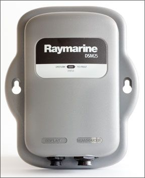
Raymarine’s DSM25 500-watt black-box sounder, housed in a waterproof box measuring 8x5x2 inches, must be mounted near the display unit.
The A60/DSM25 capabilities surpass any other unit in our test and are normally found only on much more expensive fishfinders. Some of the most exotic features are three different A-scope looks, a four-function zoom, adjustable-range bottom lock and shift, and a rotary knob for gain control. Testers particularly liked the unit’s knob control for manual gain. It was the only unit in our test to have that capability.
288
0)]
During testing, it marked the three submerged targets fairly well in auto gain, and manual gain fine-tuning improved the view. The A60 display presents over 20 sounder tasks and adjustments through page-specific soft keys. A whole slew of additional features are accessed through the sounder menu. The ease with which users can change the most used sounder functions and access those used less often earned the Raymarine A60/ DSM25 combo an Excellent in sounder user-interface.
Bottom line: The A60/DSM25 combo has superior software and sounder hardware. The display screen holds the A60 back.
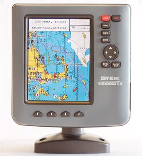
SI-TEX Colormax 5E
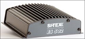
SI-TEX ships the Colormax 5E with a Smart GPS sensor. To complete our test package, we added the ES502 black-box sounder, an Airmar transducer, and a C-Map Max chart card.
We mounted the Colormax display with the supplied plastic tilt and swivel bracket, but it can also be flush-mounted with supplied hardware. It is rated to withstand powerful jetting water, but not submersion. The ES502, however, should be mounted in a protected area since it is only splashproof.
The SI-TEX Colormax 5E screen was bright during daylight viewing. Slight screen darkening was noted when it was viewed at steep angles, and this was worse when viewed with polarized sunglasses. At night, it showed some screen white-out from steep angles.
288
1)]
The Colormax offers four color palettes, six brightness levels, and 11 contrast levels. Data sometimes appeared somewhat cluttered, depending on the range settings.
Pressing “MOB” once executes the man-overboard function. The unit then flashes a warning that the MOB function is active. If data boxes are already displayed on the chart page, they will give bearing and distance to the MOB. However, executing MOB from any other page results in the visual MOB alarm only; users will need return to the chart page for navigation data. Testers liked that the SI-TEX MOB function has single-button activation, but we would prefer to not have to hunt around for the navigation information in the event the unit wasn’t on the chart page to begin with.
Multiple functions for the “Enter” key and four soft keys with page-specific functionality garnered the Colormax 5E a Good rating for chartplotter user interface. Pressing “Enter” while on the chart page brings up a “Create Object” menu with four options: Go To, Mark, Waypoint, or Range/Bearing.
“Go To” creates a waypoint at the cursor, draws a course line, and displays navigation information in data boxes. “Mark” creates the waypoint, displays a databox with waypoint information, and labels soft keys with waypoint tools. Routes are built using the cursor pad and “Waypoint.”
The Colormax does not allow rapid range changes. When testers tried to check chart redraw speeds by rapidly changing the map range, the Colormax would shift only one step at a time, and the chart would have to redraw before it could be shifted further. However, redraw rates still seemed fairly fast with this unit.
North Up chart orientation on the SI-TEX works fine, but when the unit was set to Track Up, we found it slow to respond. After a 180-degree turn, it would take as long as 30 seconds to figure out the direction of travel and adjust the chart display to match.
We reviewed the ES502 black-box fishfinder with the Colormax 5E set to a full-screen sounder page with A-scope displayed on the right side of the screen. The ES502 black box measures about 7 inches square and a tad over 2 inches high. This sounder has all the basic fishfinder functions plus a few more sophisticated ones like zoom, bottom lock, and shift.
On initial passes over the sounder test targets, the SI-TEX marked the them well but had too much noise and clutter displayed.
The four soft keys on the Colormax 5E are fully functional in sounder mode and let the user quickly adjust gain, range, and frequency. Zoom is available by using the range keys and cursor pad. The soft key functionality and range buttons made the SI-TEX sounder easy to operate.
Bottom line: Overall, the SI-TEX Colormax 5E is a decent performer, just not quite on the level of the best, in our opinion. It was the highest priced unit in our test.
288
2)]
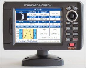
Standard Horizon CP180
The CP180 chartplotter comes with a Smart GPS sensor. For the test, we added the Standard Horizon FF520 black-box sounder, an Airmar transom-mount transducer, and a C-Map Max chart card, which all must be purchased separately.
The CP180 display comes with a plastic tilt-and-swivel bracket and hardware for flush mounting. Connections are made on the back panel of the unit with twist-lock connectors. The CP180 will interface with radar and AIS.
The FF520 must be mounted in a protected area, as it is not waterproof, and near the display unit, so it can be connected via a cable. According to Standard Horizon Product Manager Scott Iverson, the FF520 black box is being redesigned to meet IPX6 waterproofing standards by February 2009. This means that, like the Standard Horizon CP180 display, it will be rated to withstand powerful jetting water, but not submersion.
When rating day viewability, we noted the CP180 had the brightest screen in this test. Even when viewed from angles, it remained bright and readable. However, the onscreen data sometimes appeared cluttered, depending on the range setting.
The CP180 has five color palettes. Testers rated night-time viewability Good as slight screen darkening was reported. The unit also has six brightness and 20 contrast levels.
The CP180 can display three main navigation pages—chart, navigation, and highway. Chart displays a map page that can be user customized. Navigation displays data boxes and a compass rose, and Highway shows data, a compass tape, and a virtual highway. Other main menu data selections include celestial, GPS status, and NMEA data display.
To create a waypoint from the chart page, hit the “Mark” button. To edit the newly created waypoint, move the cursor over the point and select an action. The CP180 has a dedicated “Go To” pushbutton.
Building a route with the CP180 is simple and intuitive: From the chart page, press the “Route” pushbutton and use the joystick to move the cursor to the next waypoint position, then hit “Route” once more.
A single press of the MOB button executes the man-overboard function. The MOB waypoint and a visual warning are immediately displayed. If you have data boxes displayed on the chart page, they will give bearing and distance to the MOB. On any other page, only the visual MOB alarm is seen. Users must switch pages to navigate to the MOB. Not a great system, in our opinion.
Quick, successive range changes cannot be done on the CP180. The screen must redraw each time before it will go to the next range step. However, redraws were still fairly fast.
The CP180’s “North Up” orientation worked well, but “Course Up” mode was a little slow to follow as we made turns with the test boat.
We reviewed the FF520 sounder using the full-screen display with A-scope on. Data boxes take up about a quarter of the screen. The FF520 black box measures about 7-inches square and 2-inches high and is not waterproof. This sounder has zoom, bottom lock, and shift functions.
This unit painted the sample targets well. Fine-tuning with manual gain improved the picture. On the downside, this particular display, because of its landscape layout, has about 20 percent less vertical screen space to present sounder data when compared to other test units.
Because of the necessity to delve into multi-layered menus for many functions, we rated the Standard Horizon CP180 and FF520 black box fishfinder only Fair for user interface.
Bottom line: With a street price of $409 and a three-year warranty, the Standard Horizon CP180 is a bargain for a standalone chartplotter. However, the sounder’s cumbersome user-interface keeps the package out of the winner’s circle.
Conclusions
Our top picks are the Best Choice Garmin 545s and Budget Buy Lowrance LMS-525C DF. Both had across-the-board Excellent ratings for viewability, Good for both plotter and sounder user interface, and Good for sounder presentation. Another plus with these two is their internal sounders, which simplify installation and wiring, and save on precious space, too. We’d like to see longer warranties on these units.


