

380
In the February and March issues, we looked at navigation software (apps) that allow sailors to use the Apple iPad as a functional chartplotting device. Of course, with more than 38,500,000 of these touch-screen tablet computers sold since April 2010, there are many, many other apps that are useful onboard. Apple is somewhat secretive about the exact number of apps available, but the company claims over 140,000 have been specifically created for the iPad. If you add in iPhone apps, which will also work on iPads, educated guesses put the total at over 400,000.
It’s a bewildering array of software. Fortunately, Apple reviews all the apps before making them available for sale through the iTunes store (www.apple.com/itunes), so all of its apps have had some basic vetting. This is not to say that all the apps are good—it just means that the app will actually work on the iPad and perform more or less as the developer claims.
Compared to software for regular computers, the apps are cheap. Thousands are free, and a vast majority of them sell for 99 cents to $9.99. The low price makes it very tempting to try out a bunch of comparable apps—if you find that a $2.99 app isn’t to your liking, it’s not a terrible loss to just delete it or stick it in a hide-away folder. But unlike some other software, you can’t sell or give away an app that you’ve bought.
Unlike the iPhone or other smart phone, the iPad is actually a “tablet computer,” and it can do most anything a regular computer can do—play games, manage money, e-mail, read books, surf the Web, word process, stream NPR radio, post to Facebook, play music, and so on. Its battery life is excellent, and you may—like our tester, cruiser Ron Dwelle—replace your onboard laptop with the iPad.
Connecting it to other systems (wind instruments, autopilot, etc.) on board requires establishing an on-board Wi-Fi system. The iPad’s Internet connection is primarily through the 3G cell-phone network. If you’re in a marina with good Wi-Fi, you can connect to the marina’s system and access the Internet that way. If you’re out of cell-phone range, you won’t be connected.
One of the more popular bases for setting up a networked system is the Brookhouse iMux (www.brookhouseonline.com)—an NMEA multiplexer. With the iMux, you can feed NMEA data from onboard speedometers, wind instruments, depth sounders, AIS receivers, and so on into the iPad, or output data from the iPad to NMEA-compatible instruments. It’s fair to say that we’re still on the geeky edge of using such integrated systems, but they are evolving.
The iPad is undoubtedly a useful tool on a boat, but it is not optimized for life in the marine environment. We’ll be testing waterproof cases soon, so look for the report in the near future.
Unlike the iPhone or other smart phones, the iPad has a screen that is big enough to use a Web browser, and the built-in Safari browser works well. So in some instances—Youtube, FaceBook, your favorite magazines—it’s just as easy to use the regular website rather than downloading another app.
We’ve field tested dozens of marine-related apps over the last few years, but the following are our among our most used, non-navigation apps for the iPad. All are available through iTunes.
238
Document Storage
One of our principal onboard uses of the iPad is storing PDF documents. Whereas we used to carry a thick briefcase full of all the owner/operator manuals for the gear onboard, our boat info, and cruising information, we now have PDF versions of all those on the iPad. For the modestly equipped 36-foot test boat, there are 57 PDFs, along with 51 photos of such things as masthead wiring and steering-system cabling. It can be a long winter project to download the manuals from manufacturers websites and to take some photos, but it’s worth the time investment once they are handy and accessible, without taking up prime storage real estate. The iPad’s built-in app, iBooks (free), is a good PDF reader, and all you’ll really need. However, some people prefer the Good Reader ($4.99) app because of its ability to organize files, make notes, and annotate documents.
Weather Apps
Weather is obviously vital to the sailor, and there are over 1,400 weather apps for the iPad. If you already have a favorite weather website (Weather Underground, Weather Bug, Weather Channel, AccuWeather, NOAA Weather Radio, etc.), there’s probably an app version for it, and most of them are free. We like Weather Bug’s free app (www.weather.weatherbug.com) but can’t really claim that it’s significantly better (or worse) than the other commercial weather apps.
Many of the navigation apps that we reported on in the February and March issues also report current weather and forecasts. Some major weather websites also send weather Tweets, a useful feature for those who use Twitter (www.twitter.com).
Note that current weather information and forecasts depend on being connected to the Internet.
There also are a couple more specialized, sailor-oriented weather sites that are worth considering.
• Marine Cast: Designed by InfoBridge, Marine Cast is the iPad app for the popular SailFlow website, which we’ve used regularly for years. Coverage is limited to SailFlow’s coverage area, which is pretty extensive, but not comprehensive. Information, gleaned from WeatherFlow’s weather data, is displayed in both text and graphic formats. If you don’t already know SailFlow, check out the website to get an idea of how they present info: www.sailflow.com. ($5.99)
• Maritime Weather Gennie: Maritime Weather Gennie, made by video-game designers Monkey Armada, is a basic app that displays fairly realistic-looking instrument graphics for wind speed and wave height, with forecasts. If you prefer graphics to text, this is a good, simple app. ($1.99)
• PocketGrib: GRIB (GRIdded Binary) is a data format commonly used in meteorology to store historical and forecast weather data, standardized by the World Meteorological Organization. GRIB software converts the data into usable (viewable) information, usually overlaid on maps or charts. Several of the chartplotter apps overlay GRIB data on a chart. PocketGrib, designed by Nick Brennan, allows users to download, view, and analyze current and forecast global weather data (wind, precipitation, pressure, temp, wave data, etc.) on their iPad (and iPhone or iTouch). PocketGrib will appeal to the sailor who likes to see the data that underlies everyone else’s forecasts. It has very good graphic and textual display of the GRIB weather data, overlaying the info on maps (not charts). The data is updated every three, six, and 12 hours. (99 cents)
• iGrib: The iGrib app, a GRIB-file viewer made by the UK-based Mojoso, is similar to PocketGrib, but it has slightly better graphics, is updated less (twice daily), and costs six times as much. ($5.99)
• Weathertrack: Another GRIB-file viewer, Weathertrack offers professional-level weather data. It will be overkill for most sailors, but if you’re a weather enthusiast and don’t mind the price, this is for you. The app is designed by Best Search Info Brokerage. ($19.99)
Tides & Currents
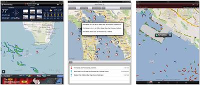
Most of the tide apps need an Internet connection (through Wi-Fi or 3G) for current information. Several of the chartplotter apps we’ve reviewed include good tide information, particularly iNavX, Navionics, and Charts & Tides. If you have the navigation apps, you won’t necessarily need these other apps, but there are some good stand-alone tide and current apps.
• AyeTides XL: Hahn Software’s AyeTides XL is the best of the tide apps, and the most expensive. It features both graphic and textual showing of tides and currents from NOAA. If you buy iNavX and this app, it will pop up when you run iNavX. Tide database is stored in the app, so no web connection is needed for tide or current predictions. ($9.99)
• NOAA Buoy & Tide Data: The NOAA Buoy & Tide Data app by Verona Solutions reports info from NOAA’s National Data Buoy Center, including tide predictions near the buoy’s location. It can be a bit hard to locate the buoy by name (for example, do you know where “HCEF1-Highway Creek, FL” is?), but the info is there. ($1.99)
• TideTrac: This new app sources tide data from the thousands of U.S. coastal stations. With graphic and textual display, the app also has a Favorites feature, shows moon and sun phases, and offers tide predictions through 2012. The bonus is that it can be used offline. ($1.99)
• Tide Graph HD: Brainwave’s Tide Graph HD app uses U.S. coastal stations. It presents the tide info in both graphic and textual form, and offers graphs that show the sun and moon phases. This is a cheap alternative to the similar AyeTides XL. ($1.99)
229
Instrument Display
These apps replicate onboard instrument displays, using the iPad’s GPS information.
• Marine SailMaster HD: The Marine SailMaster HD app, designed by Leland Roys, shows an inclinometer (or what we call the tilt-o-meter) and GPS speed, heading, and lat/lon in a traditional-styled dashboard visual. ($1.99)
• Marine Instrument Display: Veera Solutions OY’s Marine Instrument Display is like a mast or nav-station repeater, displaying such things as speed over ground, course over ground, trip distance, heeling, and lat/lon. It looks nearly identical to the instrument display in iNavX. ($2.99)
AIS
Automatic Identification Systems (AIS) apps are not AIS transceivers or receivers. Instead, they depend on volunteer organizations, who collect the current AIS position reports and send them out via the Internet. The receivers cover limited areas, but the organizations are actively seeking more volunteers. Apps require an Internet connection by Wi-Fi or 3G.
• MarineTraffic: MarineTraffic is based in Greece, but they offer coverage of 2,000 ports, including good AIS coverage in the U.S. You click on an area in a world map, and an enlarged map pops up showing the location and information (speed, course, destination, etc.) on vessels equipped with AIS transceivers. There are good visuals, including photos of most of the commercial ships. The app is a handy tool, but users should remember that it’s an app operating on volunteer participation, not a full-function AIS device. ($3.99)
• Fleetmon: Jakota Design Group’s Fleetmon Mobile Vessel Tracking and Shipfinder app reports live AIS positions as relayed by Digital-Seas.com, the ship-spotters community database. Testers found this to be a very good app, but its price seems extraordinarily high. ($24.99)
Knot Tying
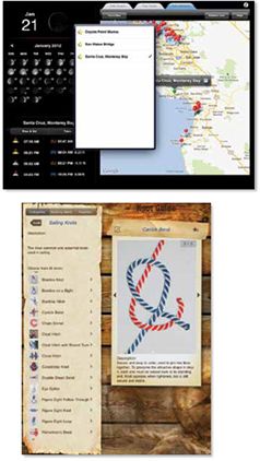
• Knot Guide HD: Designed for the iPad, Winkpass Creations’ Knot Guide HD is an excellent how-to-tie knots app. The guide uses full-color photos to walk you through tying such knots as the Carrick Bend, Klemheist Knot, and West-Country Whipping. (We love this app, though it’s not used day-to-day.) ($2.99)
• Sailing Knots 4 iPad: This knot-tying app is more basic but less expensive. It features step-by-step illustrations for the most used sailing knots. ($1.99)
• Animated Knots by Grog: From the operators of one of our favorite knot-tying websites (Grog LLC, www.animatedknots.com), the Animated Knots by Grog iPad app is the most full-featured of the knot-tying apps we’ve checked out. It uses step-by-step animations to show users how to tie dozens of useful knots. It even offers details on each knot’s use, advantages, and disadvantages. The added features are worth the extra couple of bucks, in our opinon. ($4.99)
Miscellaneous
Out of the hundreds of other sail or cruising apps available for iPad, there are a handful that we wanted to highlight here; some are practical, and others are just for fun.
• Marine Rules & Signals: Imray’s compendium of Rules of the Road and Signals, plain but well organized. ($5.99)
• RYA Handy Racing Rules: The Royal Yacht Association teamed up with Imray to offer this app, a very thorough handbook of the rules for racing sailboats. ($1.99)
• Celestial: Navimatics’ Celestial app performs sight reductions, calculates fixes, keeps track, and offers a complete Almanac (1980 to 2,099) of the positions of the sun, moon, planets, and 57 stars. If you’re into celestial, you’ll love this app. ($14.99)
• Boating Calcs: This app, by DoubleDog Studios, contains a variety of calculators, including unit conversions, fuel calculations, mechanical and electrical calculations, propeller references and calculators, etc. It’s probably most useful for naval-architect types, but it’s also handy for the do-it-yourself-er or boatbuilder. ($4.99)
• Marine Chart Symbols: This is a useful app by Imray that offers all the standard chart symbols, and it is easier to use than the free PDF downloads of Chart No. 1. ($4.99)
• SeaMap US HD: SeaMap, designed by lukassen, is simply a chart viewer, not an interactive plotter. The simple and straightforward app uses NOAA raster charts. ($1.99)
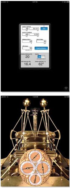
• Anchor Watch HD: This anchor-watch alarm, offered by Lukassen, works much like an anchor alarm function on a GPS or chartplotter. It’s very basic. ($1.99)
• DragQueen: Another anchor watch alarm, DragQueen by Active Captain is basically as good as Anchor Watch HD. (Don’t google “DragQueen” if you value your browser’s purity; just search for it in the iTunes store.) DragQueen is an iPhone app, so it doesn’t take advantage of the big iPad screen, but it functions very well—especially for a free app. It also shows the GPS’s horizontal accuracy. (Free)
• H1 Longitude Time Keeper: Made by Tech Center Labs, this is a working visual image of John Harrison’s famous 18th-century Sea Clock, H1, which he built to keep accurate enough time to make longitude navigation possible (ultimately resulting in today’s atomic clocks and GPS). Set your iPad to Greenwich time and watch the clock keep time. Neat, but oh how clocks have changed! Proceeds from the app’s sales go to support the National Maritime Museum in Greenwich, England. (99 cents)
• SailSim XL: The SailSimXL, designed by Digital Forge, is a sailing simulator for cruising and dinghy sailing. If you have new or young crew looking to learn to sail, this is a good basic app. You can see a good video of how the app works on YouTube. ($1.99)
• Signal Flags Info: This app, made by Gigs Inc., is pricey, but it covers everything you’d want to know about nautical flags, and more. It details all 40 international code flags and their uses. ($9.99)
• Nautical Terms for the iPad: There are several nautical dictionary apps out there, but we’ve found Substatica’s Nautical Terms for the iPad to be a bit better than the rest. (99 cents)
• Boat Owners Mechanical and Electrical Manual: This app, designed by Mobile Systems, is the excellent classic book, “Boat Owners Mechanical and Electrical Manual” by Nigel Calder, re-formatted for iPad use. (Oddly, Calder is not mentioned in the app ad.) The price is the same as retail list for the hardback, but you can buy the hardback for $35 at Practical Sailor’s online bookstore (www.practical-sailor.com). There’s no Kindle or other e-version of the book. If you prefer keeping digital reference books onboard, this is a must-have resource to add to your e-library. ($49.99)
• Cruiser’s Nav: Deep Blue Water Production’s Cruisers Nav app is a compendium of information covering what you need to know to enter 51 foreign countries: customs procedures, fees, documents required, and so on, plus encyclopedia style descriptions of each destination. (They promise to keep adding countries.) While most of this info can be gleaned with a little Web surfing, having it all in one place is a handy timesaver. ($7.99)
Just for Fun
Boost your pirate savvy with these free apps. TripLingo Pirate Edition is a language guide that features over 100 piratic references, complete with audio, cultural tips, and phonetic spellings. Find out your pirate name (or stripper name or Jedi name, etc.) with a.k.a. — Your Favorite Name Generator. This one is great for a few laughs, especially around the cockpit at happy hour: For instance, a.k.a. pegged one of our crew’s pirate name as “‘Squinty Boots’ the Well-Endowed,” and our office “admiral” was pirate-named “‘Dastardly’ Chains Ridingcrop.” Rounding out the free pirate fun is the Pirate Insult Generator by Pirate Monkeyness, which offers such witty quips as “Ye smell like ye been swimmin’ the bilge, ye scrappy cur!”
What Did We Miss?
We looked at a total of 427 apps and picked the above apps out of that bunch. But we have undoubtedly missed a good sailing-related app or two in this rapidly developing field. E-mail us and tell us about your favorite, must-have apps for your tablet or smart phone. Send emails to [email protected].
Active Captain
www.activecaptain.com
Best Search Info
www.weathertrack.us
Brainwave
www.neptunesdefenders.com
Deep Blue Water
www.deepbluewaterproductions.com
Digital Forge
www.thedigitalforge.com
Gigs Inc.
www.gigs.com
Grog LLC
www.animatedknots.com
Hahn Software
www.ayetides.com
Imray
www.imray.com
Jakota Design Group
www.fleetmon.com
Leland Roys
www.caffeinatedconsulting.com
Lukassen
www.luky.nl
MarineTraffic
www.marinetraffic.com
Mobile Systems
www.mobisystems.com
Mojoso
www.mojoso.co.uk
Monkey Armada
www.monkeyarmada.net
Navimatics
www.navimatics.com
PocketGrib
www.pocketgrib.com
Substatica
www.substatica.com
Tech Center Labs
www.italentproductions.com
TideTrac
www.tidetrac.com
TripLingo
www.triplingo.com
Veera Solutions
www.veerasolutions.com
Verona Solutions
www.veronasolutions.net


