
")
Cruising the remote west coast of Vancouver Island is the dream of many Pacific Northwest sailors. The journey includes the 80-mile passage from Race Rocks near Victoria, British Columbia to Cape Beale, the entrance to magical Barkley Sound on the west coast of Vancouver Island. With a myriad of isolated islands and anchorages, Barkley Sound is a mecca for those adventurous enough to challenge these waters.
Getting there includes transiting Juan de Fuca Strait separating Vancouver Island from Washington State for about half the distance to Cape Beale. The remaining 40 miles is exposed to the open Pacific Ocean, unforgiving to vessels of all sizes. For small boats, the 12-mile-wide strait is notorious for strong inflow winds during spring and summer afternoons, significant tidal currents and numerous commercial deep-sea vessels traveling in designated shipping lanes.
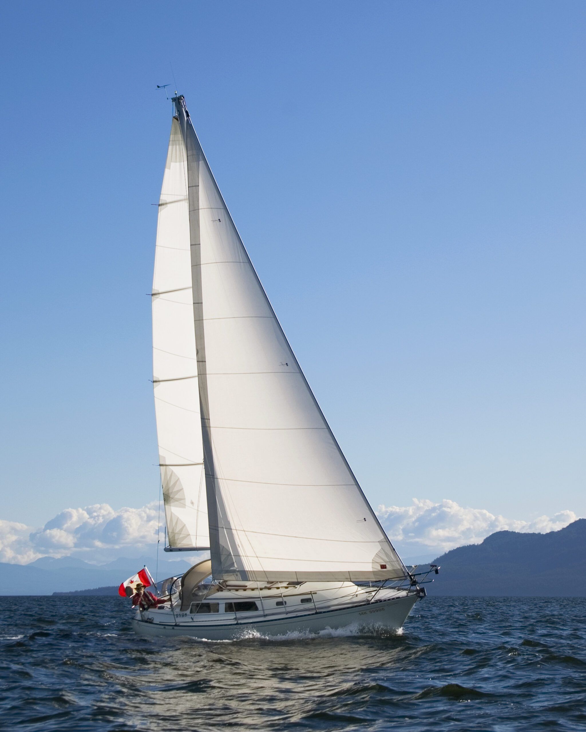
Aboard Natasha, our 1978 Islander Bahama, the spring voyage out Juan de Fuca was completed without drama. A couple of weeks of adventure in this sailing wonderland was enjoyed by all. Eventually my crew was put ashore for work commitments and I was single-handed for the voyage to Victoria and home. I was hoping for an invigorating downwind sail on the return, preferably under sunny skies with westerly winds.
Planning the Return to Victoria
The evening before departure for the trek to Port Renfrew, I listened to the Canadian Coast Guard weather broadcast and studied the cellphone weather apps. It appeared that I would likely encounter sunny skies and light westerly winds until late afternoon, the winds then rising to 15 to 20 knots. Sure enough, the following day’s wind remained light while I motored over the 6 to 8 foot westerly swell and 1 to 2 foot surface chop. I did get a few hours of sailing in when the winds increased briefly before my arrival at the marina in Port Renfrew.
That evening, I listened to and studied all the available weather and wind predictions for the second day, the 40-mile leg to Victoria in Juan de Fuca Strait. All information pointed to more of the same, light winds until late in the afternoon, then building to 15 to 20 knots from the west. Current predictions required passage before the turn to ebb against me at Race Rocks at 1730 hrs.
The Foggiest Idea
I cast off early under sunny skies, a coffee and fresh muffin in hand. The weather apps still called for light wind. I motored towards Juan de Fuca Strait three miles away, noting a fog bank ahead. Having anticipated a sunny day with little or no wind, the fog bank was a surprise! Not forecasted, nor anticipated, and perhaps just a local phenomenon, but there it was. I added another layer of clothing.
I listened to the VHF weather channel to hear the morning broadcast. I was surprised to hear there was now a strong wind warning for Juan de Fuca Strait, but no mention of fog. The staffed lighthouses along the coast were reporting “0” visibility in fog just the same. The mainsail was hauled up as I rounded the headland into Juan de Fuca Strait, the light westerly breeze coming over my starboard quarter. I did not consider turning back. I had sailed in fog before despite not having radar and Natasha was equipped with the latest GPS chartplotter at the helm along with an AIS transponder.
“Following” the Coast
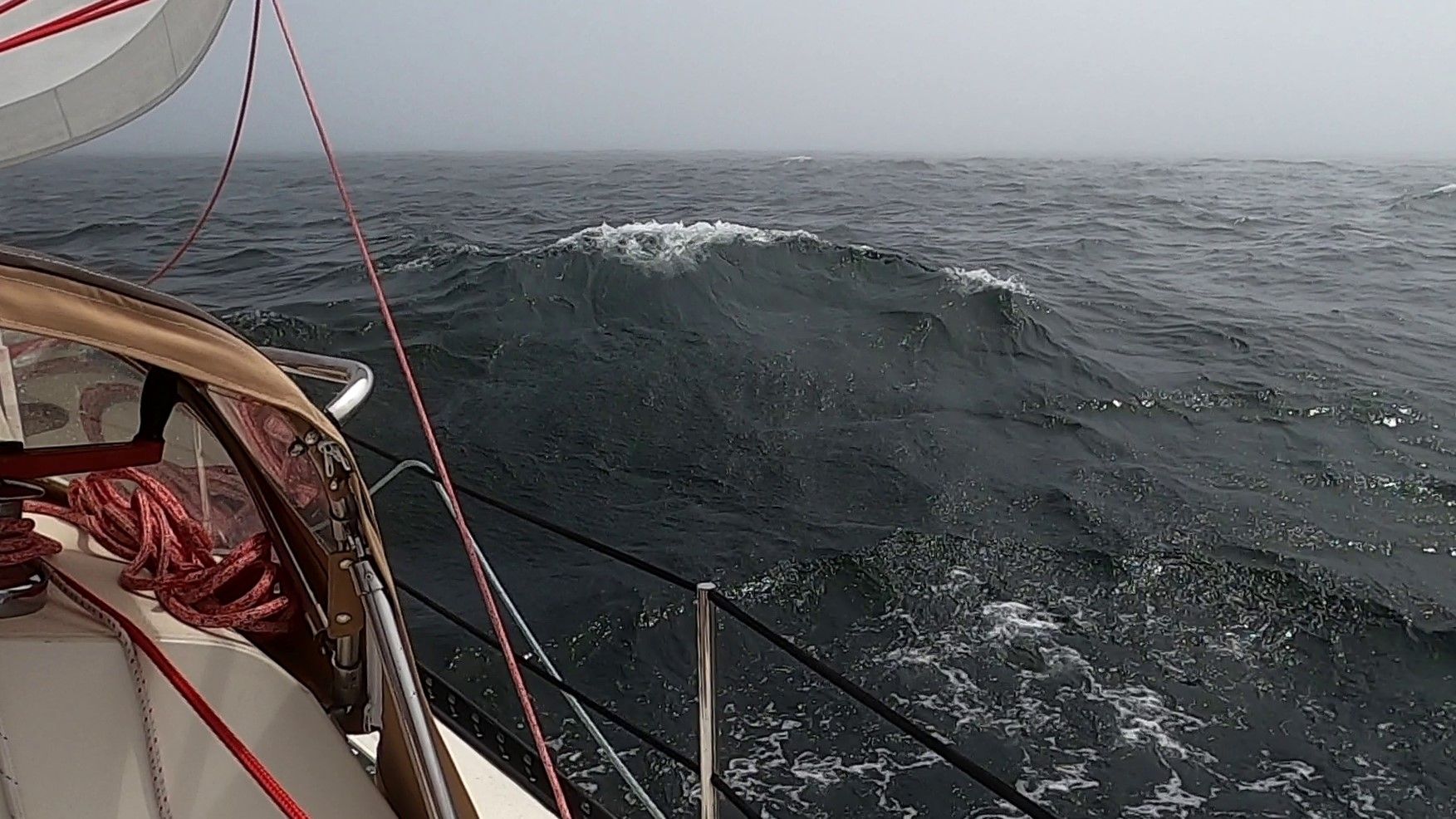
I played the back eddies close to the shore to avoid the adverse current still running against me in the Strait. Although I was less than a quarter mile from the nearby shore, it wasn’t visible through the fog. I set up the chartplotter for close-range work, following the shore details. The westerly wind filled and the genoa was rolled out. I was sailing on a very broad reach, dipping into indents along the shore. Monitoring the chartplotter, I was able to see my progress, the electronic chart moving along the shoreline irregularities. The fog and building seas were somewhat intimidating against a lee shore, but with this technology I was confident I would have a safe passage.
Eventually, the shoreline of Vancouver Island straightens out in this area with no further significant headlands. I was now out in the adverse current, the tide to turn in my favor shortly. I was sailing at hull speed on a broad reach, the wind building and keeping the sails filled. The situation was very manageable and I was looking forward to the current changing to assist my GPS speed over the bottom. I recall thinking how fortunate I was that the wind was from the perfect direction, a soldier’s wind, allowing me to sail along the coast without having to run wing-and-wing, nor having to gibe to stay close to the shore.
That Horn Is for You
My glasses misted over from the fog and I had to keep wiping the lenses to see the chartplotter clearly. I was sailing hard, bracing myself in the cockpit as the waves flung Natasha about. I heard a foghorn ahead to port and thought to myself, “Interesting, I didn’t know that Sheringham Lighthouse had reactivated the foghorn.” I believed that horn had been decommissioned years ago, but the sound came from where Sheringham Lighthouse should be. About the same time, I heard the deep moan of a ship’s whistle to starboard and behind. A commercial vessel in mid strait, an expected sound.
Because I had cellphone coverage, I gave my wife Carey a call, letting her know I would be in Victoria later that afternoon. I decided to check the Marine Traffic app on my cellphone. My wife, and a few sailing buddies, follow my adventures on their cellphones. Unfortunately, that app goes down occasionally and, when it does, the last shown position is a few hours or days behind. As the app was coming on-line, and I was wiping my glasses once again, I heard the ship’s whistle behind and to starboard sounding closer and very, very long.
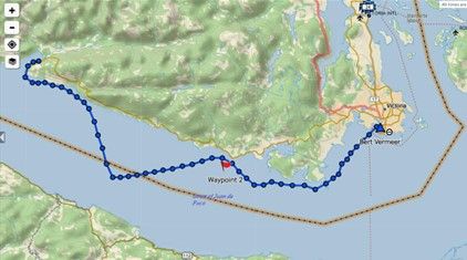
Sound can get distorted through fog and I didn’t think too much of how much closer it sounded. I thought, “Oh, someone is being warned to get out of the way.” Imagine my surprise when the app came up and showed my location as being in the middle of the Traffic Separation Zone between the inbound and outbound restricted shipping lanes of Juan de Fuca Strait, 10 miles from where I believed I was! I was about to enter the inbound lane in front of a deep-sea vessel—that ship’s horn was for me. Get out of the way!
Chartplotters Do Indeed Freeze
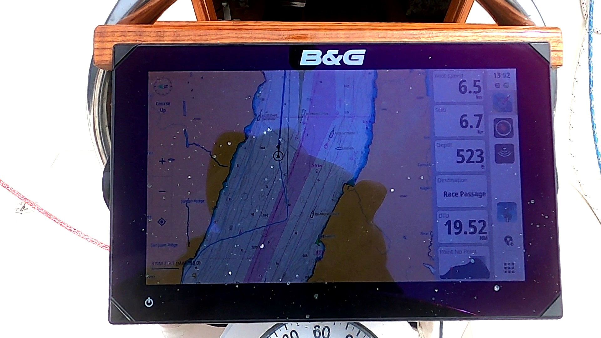
My immediate reaction was disbelief, the phone app was wrong, I thought. I checked the chartplotter and it was showing me right along the Vancouver Island shore where I believed I was. The boat speed through the water, speed over ground, depth displays were all active and functioning. Then, peering closer at the chart display, I noticed that the image of the chart was not changing—it was frozen! Zooming in and out with my fingers changed the size of the image, but not the vessel position.
No deep-sea AIS signals were displayed in the broader picture. Where was I?! Which device was I to believe? A cellphone with an app that worked occasionally, or a dedicated (and new) top-of-the-line chartplotter? Visibility was still only a quarter mile and I was sailing hard in over 20 knots of wind in significant waves. The nearby ship’s horn had me seriously doubting my chartplotter.
Calling for Help and Rebooting
Unable to establish clear communication with the Canadian Coast Guard (Victoria) on VHF 16 I was asked to dial #16 on my phone. I wanted to verify my position. I could not believe that I had sailed that far into the Strait. The Coast Guard was unable to confirm my position and my only option appeared to be rebooting the chartplotter. My fear was that the malfunctioning unit would fail to turn back on. I would lose not only the charting, but both boat speed and depth as well as they were incorporated into the chartplotter. Waiting in agony for the screen to come back up, I prepared to gibe immediately if necessary. I didn’t want to gibe if the shore was only a quarter mile to port, where I believed it to be.
Out of the Lanes and Back on Track
When the plotter finally did come back online it showed me right where the cellphone had me. I made an immediate gibe to port to head back to the Canadian shore and out of the shipping lanes. Now that I had confirmed my location, and identified the hazardous commercial traffic on my plotter, I was aware of my precarious position. Communicating with the Coast Guard and Traffic Services for Juan de Fuca, I re-crossed the outbound traffic lane without a problem.
The fog and cold persisted as Race Passage and the turn towards Victoria slowly crept closer on the chartplotter. Nothing but grey waves, grey fog and grey sky. The current, as predicted, was now pushing me along at 2 to 3 knots in addition to my sailing speed.
Finally, just after 1600 hours, Race Rocks appeared to starboard out of the fog. Within minutes, as I rounded the headland towards the Victoria waterfront, the fog dissipating and the skies once again blue. The fog bank rolled on ominously behind me.
What Have We Learned?
Secure to the docks in front of the stately Empress Hotel in Victoria’s inner harbor, I reviewed the day’s misadventure. This incident could very easily have ended in disaster. I was following the wind as it backed to the west, unknowingly sailing me away from the shore. If the wind had swung to the south I would have slowly veered to port, luring me into the nearby shore. Would I have seen the breakers through the fog, and recognized the danger in time, to avoid off-lying rocks?
Why the Freeze Went Unnoticed
Why did it take me so long (two hours) to recognize the defective chartplotter screen? One of the reasons I had replaced the old plotter was that its screen would sometimes freeze up. When it did, everything froze, the speed/depth numbers would stop, and the chart would not move. That failure was very obvious. I wanted a more reliable plotter, did the research and installed a replacement.
Cockpit Habits and Complacency
When sailing, I generally sit on the leeward cockpit coaming to see the genoa tell-tails. With the chartplotter mounted on the binnacle in front of the wheel, I can see the screen at an angle. I was sailing by the wind, watching the wind instrument (separate from the plotter) and genoa tell-tails while glancing at the chartplotter occasionally to confirm distance from shore. The boat and GPS speeds were displayed actively, the numbers changing as I looked.
On the same screen the boat icon was where I expected it to be, a quarter mile from shore. As I was sailing near the shore, I had the screen set for close-up work, about a two-mile radius. I didn’t study the screen to see if it was actively changing with the shoreline moving, with the changing numbers I was confident that the system was working. I was comfortable with where I was.
False Sense of Security
Before the introduction of modern GPS-based chart displays, I would have plotted a course on paper charts with compass headings and landmark timing at given speeds. I would have been paying very close attention to the compass.
The navigational aid warning on the opening screen that every user must acknowledge prior to using a chartplotter is routinely accepted and the message ignored. GPS and chartplotter accuracy is accepted as the norm in this electronic world. Like many boaters, I have become reliant on that technology and the comfort of knowing my exact location at all times. In this case, it was a false sense of security.
Obviously, radar would have been a valuable asset, but only if that functionality had not also frozen on the screen. I’ve sailed the coast for over 40 years without radar and without any difficulty.
In the future I will take steps to ensure the chartplotter is actually working. Rather than give the chartplotter a sideways glance, I’ll give it a close look. I’ll also look for chart movement in relation to boat movement on the screen. Finally, I’ll zoom out to observe my overall travel distance over time. Also, I’ll pay attention to the most neglected of navigation instruments, the binnacle compass—old-style navigation. Another lesson learned in the boating life.
Is a cellphone an adequate navigational backup? In this case it was a life saver, but I would not depend on it. More than a few of my sailing buddies navigate with iPads and cellphones and I shudder at the idea.
The reason for the chartplotter failure has not yet been determined.


Lots of good advice! I had an intermittent frozen plotter (somewhat less dangerous however, as the plotter would recover after a minute or two). The cause turned out to be an infinitesimally small leak in the connector on the NMEA 2K cable which took signal to/from the plotter into the pedestal and below. The leak wasn’t even visible until I disassembled the connector and then saw inside it a thin film of moisture on one pin (this was of course about the 40th thing I tried). So, not the plotter at all. The connector was supposed to be waterproof, but not quite. When I cleaned and dried it and then wrapped the whole thing in waterproof tape, the problem went away never to return. When I have time off season I will replace the cable itself. Something to check.
I have my cellphone with the Navionics app running continuously in a holder on the pedestal also – that way I can instantly check for agreement between it and the “fancy” chartplotter.
I have often had my auto GPS freeze up in the mountains. The trick in that simple case is to follow the written route instructions, which are still correct. Don’t try to restart, because you will lose the written instructions.
In the early days of chart plotters I had a long freeze-up ~ 50 miles off the east coast of the US in poor visibility (rain). Fortunately, I didn’t fully trust them back then, so I had written down lon/lat, course, and speed every 30 minutes. Dead reckoning brought me to within ~ 1/4 mile of the inlet I was looking for. I doubt I would take that precaution now, which, as you remind us, would be a mistake.
Hello Drew
In British Columbia, in high traffic areas entering airports or ferry terminals, we now have signs telling drivers to ignore the in-car GPS, look at signs and the road. Driving along at 50MPH while trying to decipher a small screen is a recipe for disaster. And yet it happens all the time.
Good tip!
I have seen firsthand too many skippers relying on just one device sooner or later running into trouble. Keeping a paper chart by the helm and plotting T D & S is simple, fun, and helps with situational awareness. Being a pilot helped develop that mindset, because redundancy is king in bad weather, whether in the air or on the sea.
I have found that following a depth contour along the coast in fog with a fathometer can be a useful adjunct to the compass and dead reckoning when electronics and radar are questionable.
Thank you all for the comments. Yes, in the modern electronic world it’s always good to have an alternative source of information. As a long time sailor I did know better and should have had more situational awareness. In a time before GPS and Loran, I would have taken more detailed action. Complacency on electronic aids is a handicap. I wonder for the safety of new sailors who don’t learn the basics of chart work (yes, remember paper charts?) with dividers and parallel rules. I still carry all that, and know how to use them, but became complacent, seduced by the technology of modern aids. A lesson learned.
The best backup for a chartplotter is another chartplotter. Just get a handheld Garmin or something in case your main plotter goes down. The backup cellphone chartplotter saved you!
Yes, redundancy is always good. But budget and space are always an issue on a small boat. This time the cell phone did save me. But it’s a lesson learned not to put complete faith in electronics and pay attention to good old fashion navigation. Thanks for reading and adding the comment.
On our boat, we have a binnacle mounted B&G Zeus 2 chartplotter but mounted in the cabin we always have an iPad operating with Navionics as a backup. I think it makes a lot of sense to have both up simultaneously.
I too have had the unfortunate experience of a chart plotter fail at just the moment in time when I needed it the most! Granted I was using the Navionics app on my cell phone, but within the cozy confines of Nantucket harbor with great signal strength I thought what could possibly go wrong? It was working flawlessly the entire time up until now (going on 10 days voyage at this point).
I departed in light/medium fog with 50-100 feet of visibility. Just enough so you could take action in case an obstacle suddenly appeared, but not enough to be able to clearly make out the next marker.
For anyone who hasn’t sailed into/out of Nantucket harbor, there is a very narrow channel one needs to navigate to get around very aggressive east and west jetties. So too do the ferries that regularly service the island. My plan was to hug the line of buoys so that the middle of the channel was clear for approaching/departing ferries.
Just as I was approaching the most critical (and narrowest) portion of this passage, where one needs to make a very aggressive turn to port when rounding the lighthouse, my Navionics app conked out. The map and my boat’s position was still being shown (thankfully) however my boat’s direction suddenly started to swing wildly, as if in any random direction.
This was not good, not good at all. Once you are in this section, there really isn’t much room, forget about when you are the only one there, now toss in the very real prospect that a (very large) ferry will be emerging from the fog trying to navigate the very same channel.
Mercifully, I was able to finally see one of the buoys, get my bearings and resume a very hair raising exit from the harbor towards the next buoy.
For the 20 minutes or so that I needed that chart plotter, it went down. I was not fully prepared for that. It was a very hair raising and tense experience. I am glad you shared your own experience regarding equipment failure of our “modern world” – one that makes you realize that you do still need to be able to read and navigate using paper and a compass.
That’s quite the story in itself Robert. Thanks for confirming that I’m not the only one out there with these sort of problems! Another lesson learned out on the water.
I would remind skippers of the col regs, which say ‘Navigate by all means available’ and the advice that a prudent skipper always has TWO independent means of establishing a possition. Ideally, if they are both electronic, then they run from different batteries. I think this story also shows the value of AIS transponders. That would have alerted both the skipper and the other vessels of the potential collision threat.