Type the words “combo unit” into an Internet search engine and you’ll come up with quite a few responses. For sale: TV/VCR/DVD combo units, fax-printer combo units, washer-dryer combo units, even cell phones that can take digital photographs. Now more than ever, people want to kill two birds with one stone.
A single piece of electronics that merges two or more functions not only saves space at the helm but also can improve the usefulness of the product. We’re thinking of electronic chartplotters with radar overlays, or split screens that display the contours of the bottom on the right and your heading on a chart on the left.
Chartplotter/sounder units have been around for several years. A color display will put you over the $1,000 mark. For under $1,000, you can get a dual-function unit with a monochrome display of about 5 or 6 inches. We focus on this market niche for this report.
What We Tested
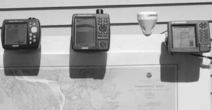
Surprisingly, only two manufacturers offer combo units under a grand—Lowrance and Garmin. Lowrance recently introduced its LMS-320DF GPS/Sonar, and Garmin sells the GPSMAP 188 Sounder and the GPSMAP 168 Sounder.
Take a look at the specs on pages 6-7. All three screens are relatively small, with the Garmin 188 having the largest, followed by the Lowrance and the Garmin 168.
The Garmin 188 and Lowrance sonar systems can function on two frequencies—200 kHz or 50 kHz. The latter works best in deep water, usually deeper than 200 feet. The 200 kHz frequency gives greater resolution and should be used for water under 200 feet deep. The Garmin 168 is equipped with only a 200 kHz frequency sounder, which will do the job for most sailors anyway.
The Lowrance reads to 2,500 feet, while the Garmin 188 and 168 read to 1,500 feet and 400 feet, respectively.
We tested the Lowrance with Navionics cartography. Garmin uses its BlueCharts. Lowrance comes with an external antenna, while the Garmin units are offered with either internal or external antennas. We tested the units with internal antennas. All three receivers are WAAS-capable.
How We Tested
We conducted a bench test, mounting the three units on a piece of plywood. We did not test the accuracy of either the GPS receivers or the sonar displays. As we mentioned in our color chartplotter article (April 15), the basics of any GPS receiver—its ability to acquire and track satellites, and to perform accurately the math that gives us such functions as real-time position, course over the ground, estimated time of arrival, and so on—can pretty much be taken for granted these days.
As for sonar, our December 2002 test of fishfinders showed that both Garmin and Lowrance do a good job of picking up known submerged objects. Your buying decision will likely center around user-interface issues, features and screen quality.
Again, here, we focused on display readability and quality—both in daylight and in darkness—and the ease of getting to and executing basic functions, such as inputting waypoints and coordinates, drawing routes, switching screens, and changing sonar settings.
In the chartplotter mode, we paid particular attention to how fast you can scroll, or how fast the plotter redraws the chart.
Another key to satisfaction is how quickly and easily you can go from a full sonar or chart screen to a split screen—or vice versa. After all, if you can’t make this conversion effortlessly, then what’s the point of buying a combo unit?
We set up each machine with cartography from the Northeast, and did all of our local planning, waypoint inputting, and route setting in familiar waters—eastern Long Island Sound and the mouth of the Connecticut River.
We’ll discuss each unit individually, then rate the basic functions of all three.
Lowrance LMS-320DF
Lowrance recently introduced this unit, which is an upgrade of the LMS 320. The only difference is the fact that the 320-DF has a dual-frequency sonar, which explains the “DF” part of its name.
The unit takes Navionics Classic XL or S charts on MMC (Multi-Media Cards). It also accepts custom, user-made MapCreate (TM) charts and the new Lowrance FreedomMaps (TM), also on MMC cards.
The Navionics chip is held behind a gasketed lid in the lower right-hand portion of the unit. A thumbscrew is used to tighten the door. The screw is not easy to work with. If you tighten it too much you’ll need a coin or screwdriver to re-open it. On the positive side, it’s difficult to unscrew it completely, so it won’t fall out.
The keypad occupies the right side of the unit above the card slot. At the top is the scrolling pad with arrows, which allows you to move crosshairs on the screen. The crosshairs serve the same purpose as the cursor arrow on other machines.
We found the crosshairs, which consist of broken lines, hard to see, especially when their intersection is moving over a cluttered part of the chart. We found ourselves squinting quite a bit while inputting waypoints and setting routes indoors. Outdoors, the lines become easier to see.
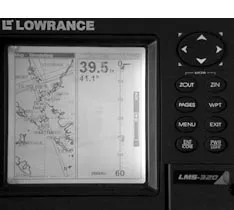
Just below the pad are the Zoom keys (ZOUT and ZIN). The Enter key is at the bottom of this eight-key cluster, next to the Power key. We’d prefer it next to the scrolling pad (where the ZOUT key is currently positioned). You’ll be using the pad and the Enter key together often, so why not make it easier to move from one to the other?
The unit also has Menu, Waypoint, and Pages keys. The Pages key serves as the jumping-off point for most operations, leading you to Status, Navigation, Map and Sonar pages. Menus under each of these choices pop up as you scroll over them. The Waypoint key gives you quick access to your list of waypoints.
The Lowrance’s square screen measures 3.5″ per side. It has the highest resolution of the three, and can hold 1,000 waypoints.
The Power button needs to be colored red for quicker recognition.
The Man Overboard function is accomplished by hitting the ZIN and ZOUT simultaneously.
The Navionics charting software we used had a couple of glitches. It labeled a Connecticut River bridge—the Baldwin Bridge—in the wrong spot, and also misidentified the Connecticut shore as Long Island.
The screen also locked up a couple of times while we were scrolling. We don’t know whether this was a computer processor issue or a cartography issue.
In our view, the screen illumination had an uneven appearance, maybe because it originates from the right side of the machine. On the bright side, the Lowrance does have a nighttime viewing option that replaces the normally bright backgrounds of the menu pop-ups with a black background. This reduces glare.
Bottom Line: The sounder, with its many functions, is this unit’s selling point. If the crosshairs were a pixel or two bolder, or could be adjusted by the user, they, too, would be a selling point. As it is, they’re a frustration. The glitches in the Navionics software didn’t help the appeal of this package.
Garmin GPSMAP 188 Sounder
The Garmin BlueChart chip slides into a slot in the lower right-hand side of the machine. The lid opens by squeezing two tabs (much easier than the Lowrance). Gasketing rims the perimeter of the opening. The chart door faces down, which willprotect the chip and internal components if water gets past the gasket. Water will drip down as opposed to pooling at the door.
The scrolling pad sits in the middle of a clustering of keys, with the Enter key just below the pad at about 5 o’clock—a good spot for it. The Enter key also serves as the button you hit to mark a waypoint, and is labeled as such.
The Find key to the left of the Enter button allows you to go to your waypoint list quickly. Zoom-in and Zoom-out keys are at the very top. Hit the Page key to move through the Garmin’s page sequence. Under each page (map, sonar, compass, numbers, highway and active route), you punch the Menu key for a list of options. For instance, after hitting Menu while viewing the sonar screen you can add or take away speed, course, and water temperature numbers.
We think the Garmin units could be even better with the addition of a seventh page: As is, the map page can be converted into the combination map-sonar split screen display, which takes away the full map. It would be ideal if you could jump from a full map, to a full sonar, to a split sonar/map page at the touch of a button. The same goes for the 168. We asked Garmin about this. “On our smaller screened products, the memory makes it impossible to add that screen without taking out something else,” said Garmin spokesman Ted Gartner.
The Power button is colored red and the MOB button is yellow.
The 188 is a smooth, easy-to-use machine, but it does have a few quirks. For instance, to get a combo screen, you’re supposed to go to the map page and hit enter. In our tests, sometimes that menu would list a “show data” option that would give us the sonar screen, other times the “show sonar” label was listed. This was confusing.
Also, you cannot save brightness settings on either Garmin. The units return to their dimmest setting when repowered. The Lowrance saves its brightness setting.
Bottom Line: The best of the three. The manual is excellent, the screen is clear and bright, and the chartplotter, with its smooth scrolling, is very easy to operate.
Garmin GPSMAP 168 Sounder
The 168 sounder is the smaller, less expensive sibling to the 188. It lacks the deep-water frequency that the two others enjoy, and can only read to 400 feet. (Actually, that should be enough to keep most keels off the bottom, eh?)
The layout of the keys is similar to the 188’s, with the scrolling pad in the middle of a grouping of smaller keys. The Enter/Mark key is next to the scrolling pad—and it’s a tad bigger than the other buttons. The Zoom and Page buttons occupy the upper right-hand part of the machine, and Menu, Quit, Nav/MOB, and a red Power button are at the lower left.
The unit lacks a Find (waypoint) key, but that’s not such a big deal. You simply hit the Menu key twice. Hit the waypoints tab on the left and your waypoint list appears.
The buttons are white, and their black-lettered labeling is harder to read in the dark. We’d reverse the colors, and make the background black and the letters white.
Bottom Line: A good machine at a very attractive price. Chartplotter ergonomics are better than the Lowrance’s, and we found the screen slightly easier to read. It packs a lot of high-quality instrumentation into a compact space.
Functions/Screens/Scrolling
• Inputting coordinates. With the Garmin 188, it took us a while to figure out how to enter a waypoint using known coordinates. You hit Enter/Mark twice, intending to mark your current position, but you stop short of executing this task. Instead of hitting Enter/Mark a third time, you scroll up and edit the waypoint listed. Missing on this screen is the option “New?” like on our older Garmin 185 combo unit. It’s a much easier task on the Lowrance and smaller Garmin. With the Lowrance, you hit Waypoint, scroll to new, then hit Enter. With the 168, go to the main menu (by hitting Menu twice), hit the waypoints tab on the left, and then hit new.
• Marking current position. It’s a bit easier to mark and name current position on the Garmin units. Hit mark twice, and you can accept the number assigned or edit it. On the Lowrance, you hit waypoint twice and the unit marks and assigns a number to the waypoint. You have to hit waypoint again, then name your waypoint after pushing edit and scrolling to the name tab.
• Setting a Route. Performing this function is simpler with the Garmins. Press the Menu key twice to go to the main menu, use the scrolling pad to go to route, press Menu, select the new route option, and hit Enter/Mark. Go to the map page and start plotting. On the Lowrance, you start on the navigation page, press Menu, Enter, select route planning, hit “New,” then name it, then go to route-end, select add-from-map, and then plot the course. Whew… too many steps.
• Ease of Scrolling. The Garmins utilize an arrow for a scrolling tool; the Lowrance uses crosshairs. Again, in this case we prefer the pointer tools, but would probably like the crosshairs better if they were bolder or easier to see. The Garmin arrow keys, which are white with a black outline, are always visible and easier to pick up.
The Garmin 188 redraws its charts very quickly. The screens on the Garmin 168 and Lowrance go blank if you hold down their arrow keys and scroll for more than a few seconds.
• Indoor and nighttime visibility. The Garmin 188 was the best, followed by the Garmin 168 and then the Lowrance. The Lowrance’s screen looked a bit blotchy to us in the dark, especially when viewed at an angle. Outdoors, all units were very clear and easy to see. The screens of all three feature a nighttime viewing mode in which some elements are converted to a dark color to reduce glare.
• Manuals. The Garmin manuals are easier to use for two reasons: They each have an index, and their individual pages are better-organized, with a section of text and a section with a screen display. The Garmins also come with laminated quick-reference cards. The lamination works—we soaked one. Garmin’s “To Do This” page directs you to information for executing specific functions. The Lowrance manual has two quick reference pages, but they’re mixed in with the rest of the pages and are hard to find quickly.
• Interface of sonar, map, and combo screens. How quickly can you do it? Garmin allows you to go from full sonar page to full map page by hitting the Pages button. To do the same with the Lowrance, you have to hit the Pages key, go to map, then go to full map, then hit Enter.
With all three units, you have to go back to the map screen first to convert to a map/sonar combination screen. With the Garmin 188, press Menu and a list of options pops up. You press show-sonar twice to get the split screen. It’s a similar drill with the Garmin 168. Page over to the map page, hit Menu and then “full screen map off.”
On the Lowrance, you hit Pages, scroll to map and hit it, then scroll down to “map with sonar” and enter.
Conclusion
Those who don’t feel strongly about deep-water sonar capability should strongly consider the Garmin 168. It enjoys all the benefits of Garmin’s intuitive, easy-to-use functions and has decent screen quality. And it’s $325 cheaper than our top choice—the Garmin 188. This unit was very easy to use, has a clear screen, and scrolls smoothly. While it has lower resolution numbers than the Lowrance, we thought its on-screen images were sharper.
The Lowrance has some excellent fishfinder features, such as its HyperScroll, which locates and displays targets at higher boatspeeds with increased soundings per second. The Lowrance can also read the bottom to 2,500 feet, which is 1,000 feet deeper than the Garmin 188. Lowrance’s Steve Wegrzyn points out other benefits: “Lowrance introduced, and is still the only one, with waterproof slot(s) for non-propriety memory cards for recording sonar graphs, GPS details, and to load/display higher-detail cartography. Also, with an MMC (Multi-Media Card) and SD (Secure Digital) reader-writer for your PC, you can download software updates from the Lowrance website free, copy to MMC or SD card, and load into the unit for easy/fast/convenient operating firmware updates.”
So the Lowrance has great versatility, but both Garmin units perform most of the simple tasks more easily, and we think their screens are easier to read.
Also With This Article
Click here to view “Value Guide: Chartplotter/Sounders.”
Contacts
• Garmin, 800/800-1020, www.garmin.com
• Lowrance, 800/324-1356, www.lowrance.com/marine