

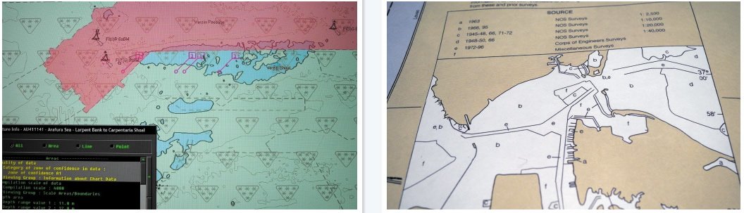
The International Hydrographic Office has a six-level rating system that indicates the accuracy of the data used to create a charted area. This zone of confidence (ZOC) layer is included in all digital charts approved by the International Maritime Organization for use in Electronic Chart Display and Information System (ECDIS). By selecting the overlay (a pattern of small asterisks, see photo), the user sees a graphic representation of the accuracy in a charted area. Most charts rely on numerous surveys, each with a different degree of accuracy, so these overlays provide vital information.
Its normal for one nautical chart to contain regions with A Level accuracy (accurate to within 5 meters), and other regions where the accuracy earns a C (accurate to within 500 meters). Recreational electronic chart producers (C-Map, Navionics, etc.), however, don’t provide a ZOC layer for review. Instead, they add warnings such as electronic charts are inadequate as a primary means of navigation, and users must push an I Agree button before putting the system to use.
For decades, NOAA placed a source diagram on larger-scale paper charts of U.S. waters. These diagrams indicated the source and scale of the survey of the bracketed area by letters a, b, c, d, etc. The letters do not directly infer accuracy limits, but the more recent detailed surveys are generally more accurate than the older hydrographic sampling.
The labeling protocol included in the ZOC display contains a one- to six-star rating system that designates the accuracy of each region on the chart (more stars equals better accuracy). Like the source diagram included on NOAA paper charts, it references the survey date and technology used to acquire the soundings and position. But it also defines a more specific rating of charted reliability. Unfortunately, many of the destinations that cruising sailors favor are rimmed with one-star zones of confidence, stressing the importance of vigilance and multiple sources of information.
Some digital cartography lets you do your own benthic survey, and contribute to crowd-sourced data. With a sounder linked to a chartplotter and GPS, sailors can now record data and send it to a service that profiles it and returns to you a file ready to load onto your digital chart. It can be shared with others; likewise, you can tap into the survey work of other cruisers. One problem is that no single, authorized entity double checks the accuracy of each individual upload. The hope is that enough DIY surveys will transect the same area, and confirm accuracy. Crowd-sourced cartography should be used with caution.
A good chunk of the National Geospatial-Intelligence Agencys (NGA) $5 billion annual budget goes to making charts and maps for the military. They have long recognized that GPS and other satellite position fixing systems offer better accuracy than current global cartography. For a while, NGA charts of common cruising areas were made available to the public. Not anymore. For the immediate future, this global portfolio of highly accurate charts will remain off limits.
Collaboration does take place, however. Googles GeoEye is able to use NGAs spy satellite imagery (at a slightly lower resolution), Microsoft lets the NGA use Virtual Earth, and now GitHub shares its Web-based graphical interface with the NGA. We are hopeful that there will be a day that all mariners will have access to the most accurate charts available.


