

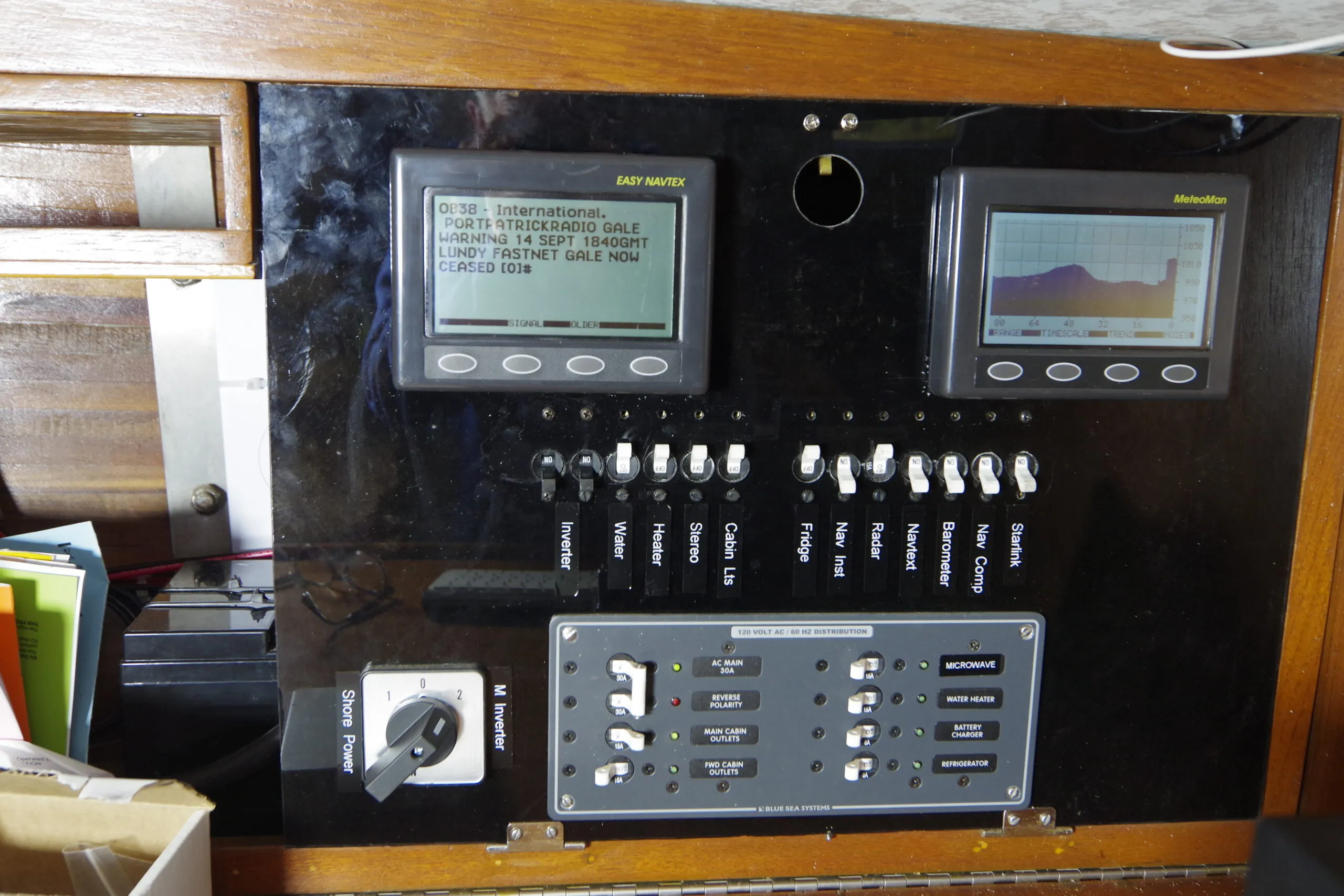
When I started sailing, navigation gear consisted of a paper chart, a few drawing instruments and a compass. Instruments usually consisted of a single instrument that showed speed and depth. That was backed up with a towed log and a lead line. Essentially, everyone was able to navigate mechanically with no electricity needed. This may sound like the dark ages, but it was still the case in the 1970s.
In the last 50 years there has been a revolution in navigation. A well-equipped boat now has multiple electronic chart displays overlaid with radar and AIS. In addition to speed and depth, we now have true and apparent wind, which can be overlaid on the chart to show tacking angles and lay lines. We have GPS that tells us where we are and we can program waypoints to create a route that the autopilot follows while we sip coffee and watch the waves pass. All this has enabled sailors to explore new horizons with confidence. Equally important, it shows us where any ships or other hazards are lurking even when the dreaded dense fog descends.
Pros of Progress
If you think all this sounds like wonderful progress, I agree. I still carry and regularly use paper charts, but my boat has a full electronic navigation system and it has made sailing safer. Although I do sometimes wonder if I am now the electrician and software engineer—not the navigator!
Cons of Complexity
Is there a downside? There are a few. The systems we use now are not systems we can repair. If any of those black boxes fail, there is nothing we can do until we get to port and buy a replacement. Rather than a single instrument, we now have a network that connects multiple instruments together, which adds another layer of complexity. All this stuff requires electricity, so we have bigger batteries with more complex charging systems to keep them happy. Sometimes there are multiple controllers sharing data on their own network.
Every season sees new additions to all this—charts now come with graphical views of harbors and photographs of the berth you are heading for. The depth sounder does not just tell you the depth but is a sonar system giving a bottom profile and details of the seabed. Your charts may also include barometric data. In the 1980s such systems would only be seen on super-yachts and warships.
Increasing Costs
Not surprisingly, the cost has increased with every level of complexity. To set up a comprehensive electronic system now costs well over $10,000 just for the navigation system. This equipment also goes out of date rapidly as new systems and functions get added. A seven-year-old system is considered old and maybe due for renewal. When you add lithium batteries to feed it and radar, an AIS transponder and a below deck autopilot for offshore passages, you can easily double or triple that cost.
If you are looking at a 45-ft. boat that costs $250,000 dollars, that may be a reasonable investment in equipment.
I am not one of the super-rich—I am a retired nurse. I sail a traditional boat that cost less than $50,000 including the full refit I am just completing, so I don’t have tens of thousands to throw at the electronics. However, I still want a solid, reliable system with many of the advantages that modern electronics bring.
There is a middle ground between the old salt still charting on paper and the all-singing NK2 network with multiple plotters and all the bells and whistles. This is how I built one.
Building an Affordable Nav System
Let’s start with a list of what you actually need to navigate safely in all weathers on today’s crowded coastal waters.
The basics haven’t changed—you still need to know course, speed and depth and a chart both for passage planning and to monitor progress. The availability of radar units, GPS and AIS have made sailing a lot safer, so for anyone in fog-prone areas or who are doing more than day sailing, those are highly desirable. The ability to get weather information while on passage also increases voyage safety. All of these are still available if you don’t have tens of thousands to spend.
Independent Instruments
My preference is that all the essential instruments should work independently. That means that each has a sensor directly connected to the instrument and works without any interconnection.
On top of that layer is a network that collects information from the instruments and relays it to the chart displays. Information such as boat speed, heading and wind data combine to enable true and apparent wind calculations. These systems also transfer GPS data to an AIS-equipped radio, and overlay radar and AIS data on the chart.
System Options
There are currently two options to build a boat network, NK2 and NMEA 0183. They have many similarities but some significant differences.
NK2
NK2 is the newer system and has a faster data transfer rate but I would argue that it was designed for larger boats with very complex systems, which is where it has definite advantages.
The principle behind NK2 is called a serial network. That means the boat has a central backbone running end to end through the boat. All the instruments and sensors link into this backbone. The information can be read by any display at any point. There are essentially two types of display, chart displays (chartplotters) and data displays. Data displays can show any data available on the system and can be general, such as a depth and speed display or more specific such as an autopilot control head. Chart displays generally carry their own internal GPS and a chart reader and can supply information to the system as well as reading it.
This sounds like a great solution and indeed it is—for some boats. A fly-bridge power boat and many large cats or sailboats may have multiple helm stations both on deck and below. Being able to choose what is displayed at which station by simply “T-ing” into the backbone rather than installing separate instruments at each station simplifies the system greatly. I argue that this was a major factor driving the development and adoption of NK2.
In addition, for power boats, the ability to integrate engine management and control into the same system (through a CAN bus) adds more benefits. As a result, the marine industry was onboard from the start and promoted it as the new standard.
Cons
Vulnerabilities
For smaller boats on lower budgets there are two significant downsides. First, by routing all data through a single backbone you create a vulnerability. The backbone cable could be damaged and each “T” on it is a potential failure point. Water or physical damage to any point will stop data passing through that node so everything beyond that point goes dead. Water penetration and some physical damage could create a short. Power surges from a fault or a near miss lightning strike can blow the power supply. With all data routed through the backbone, these situations can all lead to total loss of the system. That means no navigation, no position and potentiality a dead engine as well.
Expense
The second issue is cost. The introduction of NK2 significantly increased the cost of all boat electronics. Here are some examples:
- Chartplotter. This is typically around $1,700 for a 9-in. entry level unit but can be $3,000-$5,000 for a larger unit that includes more functions.
- Instrument displays. A basic set with speed, depth and wind starts at around $2,250 but can easily be double that. This is just for the instruments and sensors and does not include the network cabling. “Black box” sensors that plug directly to the backbone are considerably more expensive.
- Network cabling. This is not insignificant. A backbone kit for four devices will be around $300. The drop cables to connect sensors and instruments are around $50 each.
As you can see, the most basic system with a chart-plotter and three instruments will be in the order of $5,000, but typically the bill is going to be at least double that if you include other displays like a plotter at the helm or an autopilot control head. This does not include expensive add-ons like radar. For example, the offshore instrument pack for the Beneteau 40 is $15,960 and this does not include radar, autopilot or an AIS transponder.
Add to this the proprietary element. The chartplotter will only read specific, and expensive, chart cartridges. The design life of the system is five to seven years—after that repairs or upgrades may not be available. All this means your boat’s electronics are now a very significant part of the maintenance cost, possibly the most expensive system on the boat.
NMEA 0183
There an alternative for those of us with smaller boats and limited budgets. NMEA 0183 did not go away. In fact, many instruments such as GPS still use it and it has some significant advantages.
Hub and Spoke
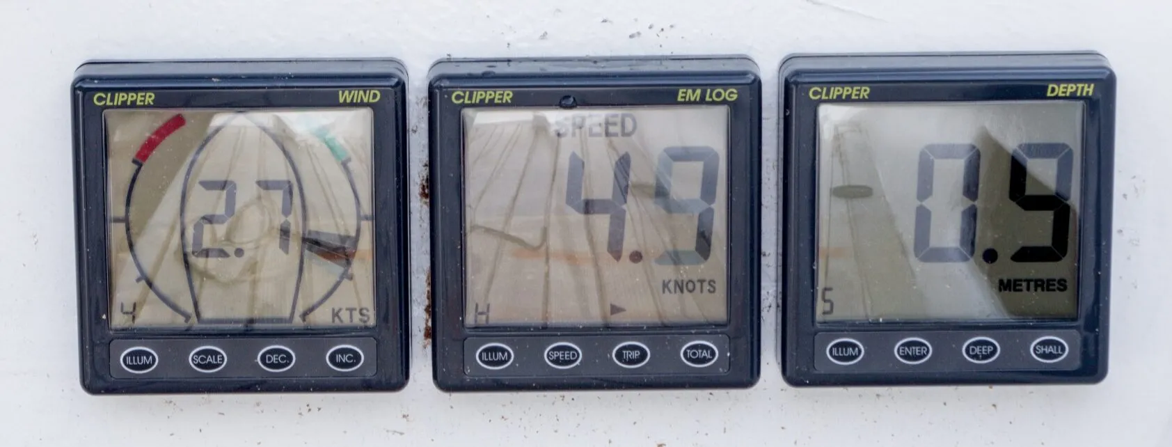
The main difference between NK2 and 0183 is not the data it is the network configuration. NK2 is a serial network but NMEA 0183 is a hub and spoke. Each display unit works independently and has its own sensor. This greatly simplifies construction and reduces cost. The instruments look similar but are dedicated to a single function instead of using multi-function displays.
The instruments output NMEA 0183 data that feeds to a central hub. Other units, such as a laptop computer, can then read this data from the hub. A unit that supplies data is called a talker and a unit that only reads data is called a listener. If a unit or sensor fails it cannot affect anything else. This makes the system very robust and fault tolerant.
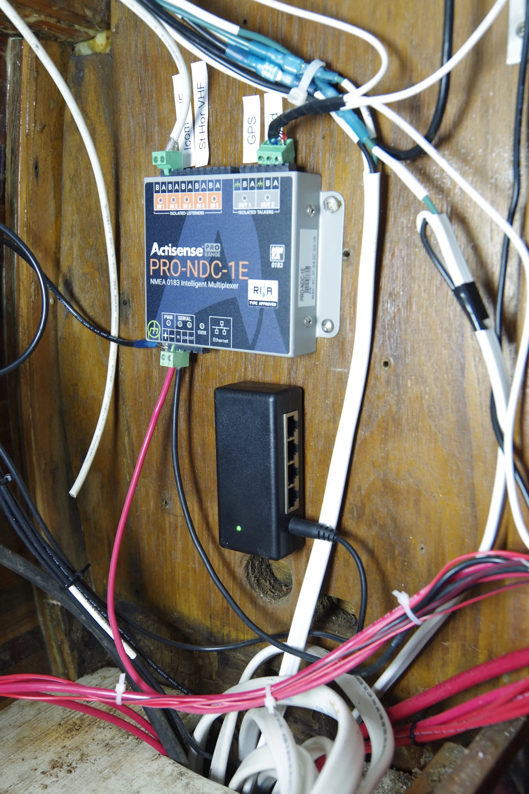
Unlike NK2, NMEA 0183 instruments have a dedicated function. A speed instrument only displays speed although it can feed a repeater but again that only shows speed. To combine data from different instruments into a single display requires the hub. The hub is called a multiplexer. Its job is to read the data from all the different instruments, sort out any conflicts and combine this into a single feed that can be read by an Ethernet or Bluetooth-enabled device.
This creates a major cost advantage. In effect, every NK2 instrument has to have the equivalent of a multiplexer built in to filter the data available in order to show only the right information on its display. For NMEA 0183 you only need one, and these are far less expensive.
Minicomputers
The second major advantage is that, instead of a proprietary chartplotter, we can now use any computer for charting and information display and choose our own navigation application. For many years people used a laptop to do this. It worked but did have some disadvantages. Laptops, like all computers, hate damp and generally have their cooling intake underneath. Also, laptops generally run on 20 V. That makes them a power-hungry beast. We need to run an inverter to convert 12 V to 120 V, then another one to drop that back to 20 V D/C. Generally, if the laptop draws 20 watts it will be pulling at least 40 watts from the batteries because of the translation losses.
Putting them on a wet chart table was also a problem because the cooling fan would suck moisture inside. Mounting them in a way so they didn’t wind up on the cabin sole was also difficult. More recently, miniature computers have become available that can be mounted in a dry safe place and linked to a keyboard and mouse via Bluetooth. For me this is a game changer. The boat now has its own permanent nav computer and screen safely mounted in a dry location, and the chart table is not cluttered up with a laptop.
Open-Source Software
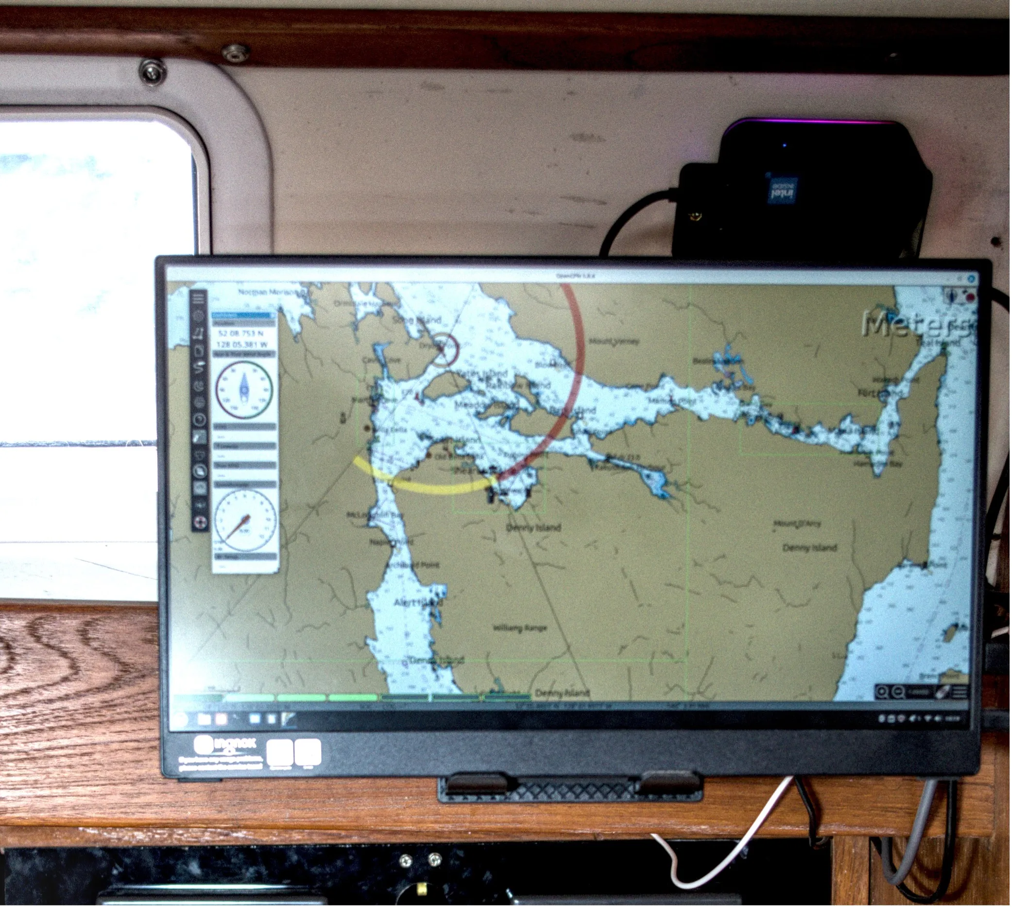
Everything runs natively on 12 V so the power consumption is also halved. The computer looks tiny but is very capable and includes a 512GB SSD hard drive. I use Ubuntu Mint Cinaman as the computer operating system, this is a free open-source O/S and is so small you can carry a backup copy on a stick. It comes with free nav software as well as a full office suite, and almost anything else you may want.
The software I run is OpenCPN, again free open source, which is as good as or better than anything you would have on a chartplotter. As you can see it will display instrument data and can also show radar and AIS overlays. The computer links to the multiplexer and radar with an Ethernet cable, which again avoids expensive proprietary components. It will directly run the new digital radars—simply plug the radar dome into an Ethernet port.
Cost
The second big advantage is cost. Here is what I spent on my system:
- Computer. There are many options, take your pick from Amazon or any retail electronic supplier. They cost around $300-$500 dollars for the computer plus about $100-$200 for a 12-in. screen. The computer is faster than any chartplotter, comes with a big hard drive built in and will run any other software you want. You can also use it for emails, weather reports, storing manuals or playing music and films.
- Multiplexer. Actisense PRO-NDC-1E2K. Around $750.
- Instruments. From NASA marine instruments in the U.K. Depth, electronic log, speed and wind with sensors around $1,600.
- GPS sensors can be as little as $40 for the USB puck style. I am using a combined GPS/heading sensor from ONWA that cost me $250 on Alibaba. This will also stabilize radar and provide stable heading data for an autopilot.
- Barometer and NAVTEX. I use NASA’s electronic barometer that displays and records pressure and wind data. I also use their NAVTEX unit that provides weather forecasts every four hours, as well as coastguard navigational information in coastal waters anywhere in the world. If you are not familiar with NAVTEX, it is a great system that records and display text. No more missing a weather update because you were on deck and did not hear the radio. The cost is an additional $950.
- Network cable. No additional costs. Instrument come complete but even if you need additional wiring they use standard screened cable.
- Navigation software. Open CPN. Open-source free software and as good as any of the ones on a chartplotter.
- Charts. Official NOAA charts for the U.S. are free to download, Canadian government charts are $20 for the west coast where I am.
The total cost was around $3,000 plus an extra $950 for the NAVTEX and Meteoman.
I also have a refurbished rugged laptop that I use on deck, but any tablet can link to the below deck computer and act as a repeater. You could also add a second screen at the helm as a repeater if you built a waterproof enclosure for it. I like to use the tablet as it can act as an independent backup with its own GPS and battery in an emergency. It is also part of my yacht delivery kit.
Adding Radar and AIS
The system is setup to use Ethernet as a direct input to the computers via the Ethernet switch and this is the simplest way to add radar and AIS assuming you are also using OpenCPN as your navigation program.
Computers can only read the newer digital radar output. If you are using a traditional magnetron radar these require a proprietary display unit so cannot be incorporated into this system.
Radar Plugins and Compatible Units
OpenCPN is a full feature program so I would strongly recommend you spend time learning its various capabilities. The help menu is good and there is also a strong user community that can answer questions.
The main way in which the program is customized is through the plugin menus. For both radar and AIS you will need to add the appropriate plugin. The radar plugin lists the radar units it is compatible with. The plugin can directly display the newer X band digital radars. This includes the Garmin HD and xHD Navico 3G and Halo. I am intending to fit the Halo 20+ or 24. Prices for all these are between $2,800 and $4,800 depending on the model.
Radar is expensive but by using a system that can plug directly into the Ethernet switch you save the additional cost and space of a second screen and processing unit.
AIS: Receiver or Transponder?
For AIS you can fit a simple receiver such as the Daisy 2+. This outputs NMEA 0183 via USB or can be wired to the Multiplexer as a talker. Cost is around $170. If you want a transponder so that other boats can see you as well these start from around $380 on Amazon. The main marine electronics providers such as Raymarine and Garmin obviously also supply AIS transponder but prices are around $1,000. The output is the same and is dictated by the AIS class B standard so the difference may be the build quality, case and additional compatibility with systems such as Seatalk or NK2.
Why Transponders Matter for Small Boats
Most units have a NMEA 0183 output either via USB or as a serial output, RS232 being a common one. If you sail at night, offshore or in areas with heavy commercial traffic a transponder is a great option. Small sailboats are easily lost among the waves and have a small radar image even in good conditions so may not be visible on the bridge of a ship until you are within a couple of miles. With a transponder you will be visible at more than 10miles making it easy for ships to give you good clearance. I have watched them do it on many occasions altering course by a couple of degrees at about 10 miles.
I have listed a few options to get you started but the price range is such that you probably want to carefully research options.
I haven’t included the autopilot as that is not strictly a navigation system but can be linked into a NMEA 0183 network. In some cases this may need the addition of a translator available from Actisense to convert from NK2 or Raytalk.
Suppliers
- NASA Marine Instruments
- Actisense
- OpenCPN
- Wegmatt—dAISy 2+ dual-channel AIS Receiver with NMEA 0183 output
- Amazon—AIS transponder
- Defender—AIS receiver
To see videos covering this install, check out my YouTube channel @sailingbrigid. You can also read more about this install and other boat projects in my book “Budget Sailboat Restorations.”







Very interesting and relevant. I am planning to upgrade my 2005 Beneteau 323. It has nmea 0183 from the vintage RM C80 MDF back to the older Icom VHF. I am installing a new RM AIS700 B transponder and Icom M510 VHF in a nav station cabinet (using Blue Sea connecting block). I intend to redirect the existing nmea 0183 to leave the AIS and go out to the C80. My helm already has analog radar hanging off a backstay. Hopefully, when I’m done, I will have radar, AIS on the C80 display like this: SeaTalk
ST60 Wind \
ST60 Speed \
ST60 Depth —> C80 M510 (GPS/NMEA 2000 or 0183 as appropriate)
M510 —–> CommandMic
Separate 12-V feed —–> Scanstrut USB-C
The ST’s use the vintage Seatalk and i also have a hydraulic autohelm below deck. So far, I’ve installed new engine mounts (Oceanic Innovations) on my Yanmar 2GM and a new FlexoFold two blade prop.
Orca sells a system that’s less expensive and links to an ipad. I’ve had very good luck with it.