

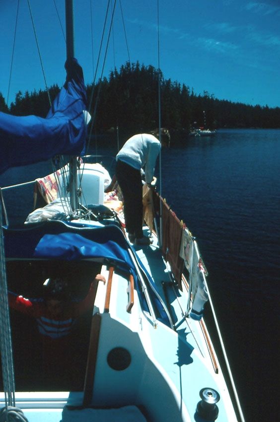
As a young family we had been sailing Dreamer, our O’Day 25, for five years, exploring the fabulous cruising grounds of the Canadian Gulf Islands from our home port of Tsawwassen, a community just south of Vancouver, British Columbia. We had crossed Georgia Strait (now referred to as the Salish Sea) in gales and calms, under sparkling blue skies and through driving rain, and enjoyed the tranquility of our favorite anchorages.
To continue reading this article or issue you must be a paid member. Sign in

Join Practical Sailor
Get full access to Practical-Sailor.com – more than 4,000 articles – for just $34.
Join today and save 42% off our full price.


In addition to the lessons learned here, a few others come to mind:
– When sailing near a danger (such as a reef), work out danger bearings in advance. In this case, Pachena Point light would have been a good candidate, allowing for a NLT/NMT line to have been plotted and used to ensure that the vessel wouldn’t have run into the rocks. Being able to shoot bearings as the boat went abeam of the light would have helped provide a course-to-steer (CTS) through the fog.
– Always have a written down set of CTS waypoints, with distances. Even with modern GPS and chart plotter navigation at hand, should something go wrong, being able to look at your DR position and navigate based on your predetermined course notes, adjusted to ship’s compass, would have helped. A waypoint well to seaward of Seabird Rocks and CTS, once past Pachena Point, would have avoided relying on the sound of surf and a foggy mistaken sight.
No offense intended to the author!
No offense taken Kevin. Some lessons are learned the hard way and yet we survive. Thanks for the comments. This incident was early in our sailing life and the points you make are valid. Unfotunately, sitting soaked to the skin in the cockpit of a small sailboat with a tiller in one hand, having been motion sick for a few hours and unable to let go of the tiller due to the violent motion of the boat, what you describe may be possible in better conditions, but not in the conditions present that day. I was aware of shooting bearings and plotting lines. They generally take two hands, preferably dry and not shaking from hypothermia, and a reasonably dry chart. Again, lessons learned. Thanks for reading!
Prior to having Starlink and the wx apps, when we sailed the west coast, as Bert mentioned it was very difficult to get an updated weather forecast. Sometimes we would stop in and chat with the lighthouse keepers at Cape Scott and Nootka Sound ( a really neat experience btw). They say to call them on Vhf and they’ll happily give you the weather info.
Nowadays, a lot of the lighthouses are not manned..unfortunately. A pair of eyes and radio contact on that coast is invaluable.
Thanks for the comment David. You sound like you’ve been there – done that! Yes, the “good old days” when you were quite literally on your own. From a sailors’ perspective it’s far safer now with all the communication and navigational aids. On our first circumnavigation of the Island we learned from the Nootka lighthouse keeper that the prevailing northwesterlies veered from northerly to westerly as the day wore on. An important tidbit of information when clearing the many headlands along the coast. Thanks for reading!