

On a recent boat delivery from Michigan to Florida, I had the opportunity to try out some new computer-based planning software from EarthNC.
EarthNC uses Google Earth images to present marine chart data by overlaying the charts on Google Earth satellite images. For $50, EarthNC provided 757 vector-format charts (raster format charts and other packages are also available) for the continental U.S., Alaska, Hawaii, and parts of the Caribbean. These charts can be used online or offline.
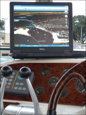
Photo by Capt. Bill Foster
When combined with a USB-connected GPS-and the ooPs (www.goopstechnologies.com) GPS software for Google Earth-EarthNC provides a real-time, moving map experience similar to modern chartplotters. EarthNC also has automatically updating weather maps with data supplied by NOAA.
After briefly familiarizing myself with the EarthNC software and charts, Google Earth, and the GooPs tracking program, I found them all extremely easy to use. If youre already a Google Earth user, getting to know the program is even easier.
On this trip, I used my laptop, an AT&T cellular air card for Internet connectivity, a USB-equipped GPS, and had the EarthNC and GooPs programs running. Although EarthNC should be considered a trip-
planning tool, this setup allowed me to watch my real-time progress, just like on a chartplotter. And as long as I had Internet connectivity, I could get real-time local weather with radar overlays from Google Earth. Very handy.
The charts show all the navigational elements contained in NOAA and Army Corps charts, including buoys and marks, depth soundings, and user configurable points of interest. According to EarthNC, the many layers of data for each area can be turned on/off for a less cluttered view.
While this software will not take the place of a true chartplotter-you cannot setup routes, store waypoints, or output the data to an autopilot, etc.-it certainly makes for a low-cost alternative to satellite cartography. Its easy to setup and use, and comes with monthly updates. Many may find comfort in the ability to compare their surroundings to actual satellite photos rather than a one-dimensional chart.
For those already using a computer onboard-as many of us are these days-EarthNC is a handy addition to full-feature navigation programs.
While Practical Sailor wouldnt recommend it as a primary navigation system, it is an excellent, intuitive, and inexpensive planning tool, one that allows you to correlate satellite imagery, and multiple layers of geographic data with chart info. For a free 30-day trial, visit the EarthNC website and see for yourself.
Practical Sailor
contributor and delivery/charter captain Bill Foster holds a 100-ton U.S. Masters License and has 30-plus years experience running boats and teaching marine electronics and marine safety, among other things.


