
")
Although there are only a limited number of mainstream chartplotter manufacturers in the North American market, the model lines within each company are dazzling, and confusing. Options are nearly endless, as are price variations. Researching on the manufacturers’ websites can prove frustrating. YouTube “help” videos seem to focus on power boat applications and can leave you feeling you’ve wasted a lot of time without a lot of useful information.
As in most cases in the electronic world, development is careening along at breakneck speed and, as you read this article, new products are emerging from manufacturing plants that will supersede currently available chartplotters and associated hardware. This article can only address what is currently available at the retail level. And for this article, manufacturer’s suggested retail prices (MSRP) are simply that, a suggestion, but a fair way to compare similar models with similar features. Better deals are available at a host of retailers. The MSRP list at the end of this article, quoted in U.S. dollars, are simply the chartplotter, independent of transducers of any kind, wind, depth, radar or installation. With today’s market volatility, prices are included as a comparison, not as actual market value.
This article will focus on chartplotters in the seven-to-twelve-inch screen size, the most common application for the average sailor. Yes, there are handheld chartplotters that are excellent when taking the dinghy for a spin. And at the other end of the scale there are dazzling 27-in. and larger screen sizes that provide so much information that you’ll never look outside the cockpit again. But here we’ll focus on what will work at the average sailboat helm, where the plotter should be. (Budget for a correctly sized Navpod to hold it.)
Questions to Ask Before Purchasing
As a potential purchaser, facing such a confusing array of models, sizes and prices, these are the questions you should ask yourself to narrow down your selection.
- Is this an initial purchase with no connections to existing instrumentation?
- Is there an expectation of networking with future instrumentation or transponders?
- Is this a purchase to supplement existing instrumentation? If so, serious consideration must include communication between the new plotter and the current instruments. As an example, having Raymarine instruments and purchasing a B&G chartplotter will work (depending on the version of Raymarine Seatalk, 1, 2 or 3), but communication will require a network backbone with a dedicated bridge to convert the proprietary SeaTalk signal to NMEA 2000 that B&G, and many others, use. This will add complexity and require technical knowledge to succeed, adding cost to the system.
- Is this purchase a replacement of an existing chartplotter, already connected to a network of instruments, perhaps previous generation? This may be the least expensive option, depending on the age of the existing network and instrumentation. But is that what you want?
- What do you want the chartplotter to do for you? Will this be a stand-alone plotter operating on its included marine chart software? Or will it be connected to a network of hardware? As a new sailor, or a sailor new to chartplotters, you may say that your intentions are to use this just like the old-style paper chart, simply navigation. But with a little experience using these incredibly powerful devices, you’ll realize just how much they can revolutionize the art of navigation and control over your vessel. Connecting wind transducers, depth/sonar transducers, auto pilots, radar displays, engine instruments, and entertainment system controls are all within reach at the chartplotter screen. The days of cutting 3-in. holes into your cockpit bulkhead for a clutch of sailing instruments are over. Plan for the future.
- Are your intentions coastal cruising? Or offshore sailing to distant anchorages? Competitive racing around the cans, or offshore? Each will require a different degree of chartplotter and associated hardware. Different needs, different gear.
Sonar (Sound Navigation and Ranging) is a technique that uses sound waves to detect and identify objects in water. It’s used in a variety of applications, including oceanography, fishing and military operations. In simple pleasure boat applications, it is usually a single, user selected, frequency sound wave used to measure depth for located under water objects (like fish). The lower the frequency transmitted, the deeper the response returned but the lower the definition displayed. Many modern transducers will have multiple user selectable (or auto select) frequencies to improve definition on screen. CHIRP (Compressed High-Intensity Radiated Pulse) sonar is a type of sonar that sends out a continuous range of frequencies instead of a single frequency. This allows for clearer images with higher resolution and better target separation. CHIRP sonar requires specific transducers with ethernet connections to matching software on the chartplotter. The chartplotter must have the capability to receive and display this information. Radar (Radio Assist Detection and Ranging) has come a long way from the original power- hungry magnetron pulse energy transmitters on rotating directional antennas. With the introduction of solid-state antennas, manufacturers could add Doppler processing to identify targets speed and direction. With an overlay on the dedicated chartplotter, manufacturers can now display boats with colors denoting conflicting courses. AIS (Automatic Identification Ship) is a mandatory requirement for commercial vessels over a certain tonnage, and a proliferation of pleasure boats transmit AIS signals, so having that information displayed on a chartplotter is becoming more and more vital in busy waterways. Almost all chartplotters identified below are capable of receiving AIS data from a dedicated receiver or AIS-equipped VHF radio and display vessel, data, course and speed information on the screen, alerting the user of potential conflict.Sonar
CHIRP
Radar
AIS
Purchasing Options
There are eight generally recognized manufacturers of chartplotters available in North America (in no particular order): Garmin, Furuno, Si-Tex, Brooks & Gatehouse (B&G), Simrad, Lowrance, Raymarine and Hummingbird. There are also a couple of fringe units advertised on the internet, Aramon and Aqxreight, direct from China. I will not address these two here.
All of these chartplotters are available from, at one end of the scale, online “big-box” retailers and, at the other end of the scale, “specialty marine electronics service outlets.”
Prices from online outlets are relatively constant with the occasional “loss leader” short term sale price listed. If you know exactly what you want, the skill to install the unit, and the patience to wait for such a sale, good for you. For the sailor who is seeking a simple, stand-alone chartplotter with no plans for a network in the future, this may be the appropriate avenue.
For the sailor with more complex requirements, or perhaps seeking more peace of mind in the coming years, purchasing from a local, dedicated marine electronics retailer/service establishment makes far more sense. Many such retailers will provide local support for the installation and troubleshooting when problems arise. And in the marine environment, problems are likely to arise!
Purchasing online leads you directly to the manufacturers help desk should a question or concern arise. A very small fish in a very large pond. A local purchase provides an intermediate source of knowledge that will have the answer and, if not, will deal with the manufacturer to resolve the issue on your behalf. After all my years on the water, I would never give up that local, intermediate source. A bigger fish in a smaller pond.
A Sailor’s Options
Chartplotters tend to specialize in some functions better than others. As an example, Furuno & Lowrance built their reputation on fish finding with an excellent sonar capability. B&G and Raymarine developed an excellent racing application that is very useful at the starting line and beyond. Even if wind instruments are not utilized to take advantage of the full functionality of race applications within the plotter, the ability to plot a start line, racecourse and mark roundings are still useful functions for round-the-cans club racing.
Charting
Most chartplotters arrive at the retailer with a charting chip included in the purchase. The two big players in this field are Navionics (now owed by Garmin) and CMap. Raymarine, Si-Tex and Hummingbird provide their own charting systems, but their chartplotters can function with Navionics and/or C-MAP.
All of these plotters will also accommodate a form of split-screen display where the operator can select what information is being displayed. Having a chart and sonar available at the same time is convenient when approaching an anchorage. Having a chart display and one of the high-end CHIRP transducers with the ability to display a combination of down and side scan can be very useful. Typically, the larger the screen, the more display options become available as there is more room to place information.
Transducers
A stand-alone chartplotter works just fine by itself. The display shows the boat icon, provides bottom details as provided by the chart application and calculates all the required navigational information such as speed over ground, distance travelled, routing, “bread crumb” trails, etc.
But what if you want more? And with familiarity, you will!
As a sailor, speed through the water may be important. Calculating time over distance while under sail is important in safe navigation. In a power boat, speed through water can be calculated based on a known ground speed (using GPS) and known water speed (factoring in engine RPM, which can be precalculated). Under sail that information will need to be gathered from the water itself through a transducer. Knowing adverse or favorable currents may become critical in calculating time to destination. As a sailor, wind speed and direction may also be an important part of remaining safe. Having that information integrated into the chartplotter can be very useful, with or without sailing instruments.
Manufacturers provide a variety of depth transducers from simple water depth to scanning sonar, from water speed/temperature to through-hull, in-hull, or transom mounted; from bronze to high-strength nylon. The choices in both transducers and mounting strategies are endless.
Aloft, masthead transducers provide wind speed and direction, wired or wireless, with recent models not requiring any rotary moving parts or vanes at all. If transitioning from a current chart plotting/instrument system that already has a functioning through-hull transducer, an independent manufacturer, Airmar, probably has an adapter/insert to accommodate the new plotter without having to drill a new hole through the hull.
The same applies to wind transducers, as long as the communication protocol is NMEA 2000. Radar antennas tend to get far more complex and using one manufacturers’ antenna on another’s chartplotter will not work. Even within a manufacturer’s line, going from the old analog radar dome to your new chartplotter will not succeed. There are digital electronics at both the antenna end and the chartplotter that communicate to make the magic appear on the display.
Networking
All of the chartplotters identified in this article will connect to instruments and available transducers, wired or wireless, through either dedicated manufacturer “ethernet” or the NMEA2000 (Controller Area Network – Can bus) protocol (or SeaTalk for Raymarine). Basic transducers share a common protocol with NMEA2000 so that information can be shared across chartplotters. If you have an older network/instrumentation you may have the older NMEA 0183 protocol. Time to update. See Sonar below.
Sharing information between chartplotters will require manufacturers specific ethernet connections. Why would this be important? If you have a chartplotter at the helm and one at the nav station below it would be appropriate to have the two communicate. Whatever action you take with one is reflected in the other so that transitioning from the nav station to the cockpit is seamless. The chartplotter at the nav station would become the primary and hold the chart data (it would have to be turned on first), the plotter at the helm would be the secondary. Not all chartplotters have this ability, it usually comes at the higher end of the product line for each manufacturer.
And just so you know, the NMEA 2000 cabling comes in different wire gauges suitable for the length of wire required to minimize voltage drop/signal strength. The SeaTalk network (RayMarine) has the same gauge for any length and requires power insertion points to boost/maintain signal strength.
Mounting
All chartplotters identified in this article have the ability to be flush mounted into a NavPod style fixture at the pedestal (where it should be, right at hand) or, for those boats with a tiller, against the cockpit bulkhead, so the helmsperson is comfortable behind the dodger and the plotter is within reach. Other options include the manufacturer-supplied trunnion mount on, perhaps, a swing-out arm in the companionway, or the end of the centerline cockpit table on a swivel. Wherever the chartplotter ends up, rest assured that it’s waterproof and can be readily seen in direct sunlight.
There are also those that use a laptop with open-source charting at the navigation station below decks. Unfortunately, I don’t have a photographic memory I can take from the nav station to the helm as I enter a rock-strewn channel or anchorage. Verbal descriptions from below competing with wind noise and rumbling diesel just does not suffice for me. A dedicated chartplotter within reach of the helm, just like the traditional paper chart in the cockpit, is mandatory in my cockpit. And I am aware of the connectivity between the nav station laptop and smart-phone or tablet, but that goes back to the previous paragraph of viewability.
Manufacturer’s Details
Detail can be mesmerizing, and confusing. This article cannot possibly go into each manufacturer’s entire line of product and detail each plotters capabilities and limitations. This guide may be considered as an assistant to practical sailors focusing on brands and models that fulfill the specific needs of a sailor. There are many excellent and very useful chartplotters available with some with helpful programs focused on sailors.
In no particular order:
Garmin
Probably the most well-known manufacturer in the field of navigational equipment from marine to aircraft to outdoor recreation, Garmin has more tools in the box than most. And like most, their marine lineup provides a chartplotter for every budgetary need. Garmin operates with Navionics charts but, like many other plotters identified in this article, will operate with C-MAP as well. Aimed primarily at the sports fishing market, Garmin offers a host of transducers of ever-increasing definition. Should the purchaser already have an Airmar transducer, an adapter is likely to be had for any of the Garmin plotters.
Striker
The Striker series of fish finders do not include a chart and will not accept a navigational chart, Navionics or C-MAP. Intended only as a fish finder with rudimentary charting abilities by the operator, this line is not suitable for navigational purposes.
Echomap
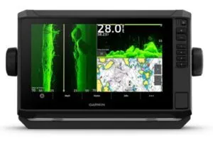
An introductory model in the Garmin line is the Echomap UHD2 series in 5 in., 6 in., 7 in. and 9 in. touch screens with key controls on the right side of the screen, but without a rotary dial. Although an economical chartplotter, the series has a host of features including, auto routing, Wi-Fi, wireless control of a dedicated electric trolling motor and split screens. The touch screen controls are contained in boxes/bars configurable by the user. The UHD2 series is subdivided into models defining sonar capabilities, the charting remaining constant. With the appropriate transducers the display will provide wind and water speed without the need for independent instrumentation, all based on the NMEA2000 network. A radar overlay is also available. Within the software is sail racing programming that allows the user to set up start lines and a course for the racing skipper.
GPSMap
At the top, available models include the GPSMap series in a host of sub-series and sizes, everything from 7 in. to 27 in. screens. The 723 series is a touch screen only, the 1022 series a touch screen with keypad and rotary dial, as is the 84 series. There are so many options within these series that a purchaser must examine the specifications for each offering to determine suitability for their application. All of the options within the UHD2 model series apply to the GPS Map series with more processor speed, higher resolution touch screens and network capability.
Furuno
The Furuno company developed the first practical fish finder in the late 1940s and has been successfully manufacturing marine electronics ever since. Furuno diversified into a host of both marine and land-based electronics, and is a well-respected name in depth sounders, radar equipment and marine radios. Chartplotters have not been left behind.
Furuno is generally focused on the commercial marine environment and their product line reflects that focus. Commercial fishing and deep-sea vessels predominate. However, there are few chartplotters in the recreational boat product line with associated accessories.
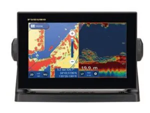
The GP 1971F is a 9 in. touch screen chartplotter with built in CHIRP sounder functionality and Navionics charts. The system can also read C-MAP charts. For sailors, there is a competitive masthead wind transducer that can display wind information directly onto the screen without separate wind instruments. The same holds true for depth and water speed through the NMEA network by way of an Airmar transducer. Furuno does not make their own recreational boat transducer for this purpose.
The GP 1871F is the identical chartplotter with a 7 in. touch screen.
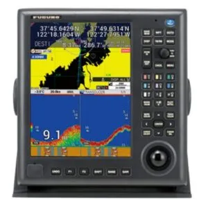
A step up, and aimed specifically at the commercial market, is the GP-3700 and 3700F, both presenting an unusual vertical 12 in. screen with keypad on the right and bottom, including a tracking ball. Both can display water speed through an optional Airmar transducer.
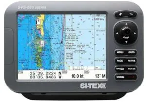
Si-Tex
A New York based company, Si-Tex Marine Electronics started up in the 1980s and offers a suite of navigational instruments, chartplotters, auto pilots, radars, sonars and AIS transponders to the mariner. As with all the companies identified here, the focus will be on chartplotters. Si-Tex chartplotters use proprietary Polaris charts which are updated automatically when within Wi-Fi coverage. The plotters can also use Navionics charts if desired. The primary focus of the Si-Tex product line is commercial or sport fishing and there is no specific programing for sail-oriented adventures.
SVS
The entry level Si-Tex chartplotter is the 4.3 in. SVS 460C and 5 in. 560CF, both controlled with keypads on the right and without touch screens. Running on Navionics with C-MAP charts as an option, the 560CF can process signals from an optional transducer to provide depth, fish finding and water speed through a NMEA 0183 or 2000 signal.
One step up will be the 8 in. SVS 880CF and 10 in. 1010CF, again without touch screens, but a user-friendly keypad on the right and an optional wireless remote. A dedicated SVS transducer allows for depth and water speed display. There is no indication of wind transducer display. With NMEA2000 connectivity, AIS data can be displayed with the appropriate receiver. And like most chartplotters available on today’s market, the screen is user configurable.
NavPro
The NavPro 1200 GPS series is divided into the C (chart) and F (fish) models and have a 12 in. touch screen, a keypad with rotary dial on the right and optional remote. Capable of trunnion or flush mounting, the NavPro series has split screen capabilities and, with the right transducer, can display water speed and temperature. The data bars are in a double row on the right and user configurable, but not transparent and so losing chart space. Interestingly, there is a compass bar at the bottom of the screen showing vessel heading instead of just a number in a data box like other manufacturers. There is no indication that the NavPro series is CHIRP compliant, nor is there any capability of wind transducer display.
The NavPro 900 GPS is identical in functionality to the 1200, just in a 9 in. touch screen.
Navico: B&G, Lowrance & Simrad
There are multiple lines within each of these manufacturers, all under the Navico umbrella and all owned by Brunswick Co. Brooks & Gatehouse is of British origin, Lowrance is American, and Simrad is Norwegian. Looking at the screens they appear virtually of the same design. A user of one can easily transition to another, the basic layout and operating system is similar. B&G has a focus on sailboat racing, Simrad on power boat application, and Lowrance on fishing. All three products appear with C-MAP charting although Navionics chart can be used.
B&G
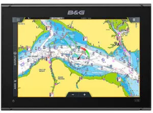
The B&G series is divided into the Vulcan, Zeus S, and Zeus 3s lines. Working on a NMEA2000 network, all can communicate seamlessly with B&G instruments. If you don’t want the expense of individual instruments, the plotters will display transducer data directly without the instrument. All are sold with an optional radar bundle with a bit of a cost savings. Transducers, both wind and depth/speed, including CHIRP, are sold separately depending on purchaser requirements.
Vulcan
The Vulcan 7 in. and 9 in. touch screen plotters could be considered their introduction line, but carry virtually the same features as their higher priced brethren, although with a slightly slower processing rate and not networkable.
Zeus
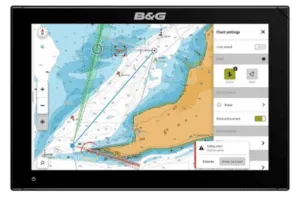
A step up will be the Zeus S line in 7 in., 9 in. and 12 in. touch screens. It has a faster processor, with a screen that can be viewed from a shallower angle. The screen is user configurable for split with the data boxes appearing in a bar on one of the edges. There are multiple pages available for additional data such as engine information, etc. Users can select a “racer” or “cruiser” option, the racing screen displays a plethora of information when wind and water transducers are in place.
Up from the Zeus S line will be the Zeus 3S line in 9 in., 12 in. and 16 in. touch screens and included keypad/rotary dial on the right, or a touch screen and remote keypad/rotary dial. A keypad/rotary dial will always be a more direct control of the image than fingers on a wet touch screen, particularly with gloves on. Again, the processor speed is improved but the basic features are the same. They are networkable to create a comprehensive system. I suspect the deciding factor will be the desired size of the screen and available room at the helm.
One of the enduring qualities of the B&G line is their commitment to racing. All models have a focus on start-line advantages, lay lines, wind and current calculations when connected to the appropriate transducers. Of course, a cruising sailor can simply select “cruising mode” and all race centered data disappear.
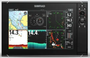
Simrad
If you’ve used the B&G line of chartplotters, the Simrad line will feel very familiar. With a virtually identical look and feel, the display and touch screen commands appear to have come from the same minds. Although now under the Navico umbrella, Simrad started as a Norwegian company, developing electronics in the marine environment since the 1940s. Like the other companies listed here, Simrad has developed an entire accompanying line of tools to assist in the marine environment including depth sounders, radar and auto pilots. Although all the features presented on the Simrad screen are applicable to sail or power, the advertising literature and web site is definitely aimed at power and sport fishing. Unlike B&G, there are no specific sailing applications.
Go
Simrad’s introduction line is the Go Series in 7 in., 9 in. and 12 in. touch screens. Typically sold in bundles that include transducers and radar, this unit is as powerful as most sailors will ever need, but with limited external communication capability. Unfortunately, the Go series is on its way out, to be replaced by the NSX series as the entry level.
NSX
The Simrad NSX series is a step up with more powerful processors and external communication features, again with 7 in., 9 in. and 12 in. touch screens.
NSOevo3S
Once into the NSOevo3S series, a keypad with rotary dial appears on the right of the 9 in., 12 in. and 16 in. touch screens.
At the top is the NSSevo3S unit in 16 in., 19 in. and 24 in. screens. With a separate “black box” processor for multi display and communication, unless you’re driving a foiling racing sailboat and need blazingly fast processor speed, this unit is probably beyond what the average sailor is likely to install at the helm.
Like the B&G line, displays are customizable to user preferences with the same vertical column(s) of data on the right side of the screen. There are multiple pages of data available at the touch of a finger, data that can be arranged by the user. But like the B&G line, the data boxes cover available chart screen area and are not transparent.
Lowrance
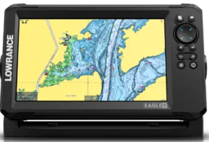
Under the same Navico umbrella is Lowrance, focused on sonar and fishing with three product lines and multiple models within each line. The Hook series is purely a fish finding unit with limited charting for inland lakes and will not be addressed here.
Eagle
Beginning with the Eagle line in 4 in., 5 in., 7 in. and 9 in. screens with keypads (no touch screen), this line is dedicated to fish finding with charts seemingly an afterthought. The standard chart is for inland lakes only. A multitude of transducers of varying abilities are offered, mostly transom hung.
Elite FS
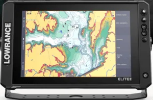
Next up is the Elite FS series in 7 in., 9 in., 10 in. and 12 in. touch screens with keyboard on the right side. Although there is no rotary dial as found in some brands, the keyboard does allow for accurate control when fingers are in gloves and the screen wet. As with all chartplotters, the basic functions of charting, navigation, route planning, waypoint addition, etc. function well. With multiple choice in transducers, including CHIRP, the sonar capabilities are quite dramatic (you can see your anchor chain swooping away!).
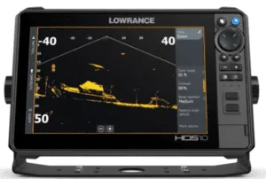
HDS PRO
Lowrance’s top-of-the-line is the HDS Pro series in 9 in., 10 in., 12 in. and 16 in. touch screens with a keyboard on the right side, similar to the Elite series. With more sonar and communication options, this chartplotter allows you to control electric trolling motors along with a host of other features.
What makes the Lowrance Elite and HDS series stand out is that the user can define the data displayed on-screen in any desired position on the screen. The data is not confined to a box or column, the selected data is simply superimposed on the chart in a transparent box, the chart visible under the box. The most important data (depth, speed?) can be displayed in oversized numerals, other data in smaller numerals. There are three size options. Raymarine has a similar set-up, other manufacturers should take note of this feature.
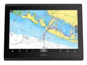
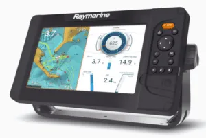
Raymarine
Raymarine has its own proprietary charting system known as Lighthouse. Both the Element and Axiom lines of chartplotters have a selection of Lighthouse chart SD cards available at time of purchase, but the plotter can be purchased without if you already have a Navionics or C-MAP card you want to use. The chart data is interchangeable.
All of the Raymarine chartplotters are programmed with racing software for the dedicated racer. On screen data blocks are configurable and can be moved in columns on either side of the screen, or top or bottom. However, the data blocks are not transparent and block out chart information.
When it comes to transducers and Raymarine chartplotters’ ability to display that information, Raymarine has defined DownVision as the simple downward traditional depth sounder, “SideVision” as side scanning sonar—view what’s under the boat to port and starboard—and “Real Vision” as a combination that provides a 3D picture below, to the sides and behind. “Hypervision” is Raymarine’s enhanced CHIRP sonar that provides a clearer image on the screen.
Element
Element S comes in 7 in., 9 in. and 12 in. screen options with control pad on right, no rotary dial, and no touch screen. They have all the typical chartplotter software including navigation, depth and wind information with connected transducers on a proprietary network, and the ability to overlay radar signals when so connected. Like many other chartplotters, the Element series allows user added information to the charting software and provides three user programmable quick-access buttons for available screens.
Element HV 7 in., 9 in. and 12 in. screens with control pad on right, no rotary dial, and no touch screen. Similar to the Element S line in functionality, the HV includes CHIRP software for more detailed underwater viewing and a faster signal processor.
Axiom
Axiom + comes in 7 in., 9 in. and 12 in. touch screens only, no touchpad or rotary control. With a brighter screen than the Element series and a faster processor, the Axiom can also network with other plotters for dual displays, cameras and engine instrumentation. Axiom RV also has the bonus of being able to display RealVison sonar.
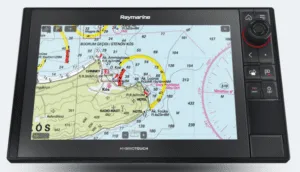
Axiom 2 Pro is 9 in., 12 in. and 16 in. touch screen with touch pad and rotary control. The screen brightness has auto control, and the touch pad buttons are user configurable. Like the Axiom +, the Pro can network with other plotters for dual displays, cameras, engine instruments and external Wi-Fi units. Pro S comes with CHIRP sonar, while Pro RVX comes with HyperVision Vision sonar.
Axiom 2XL is the Pro series in larger 16 in., 19 in., 22 in. and 24 in. touch screen displays.
Hummingbird
The Hummingbird line of chartplotters is a division of Johnson Outdoors based in Eufaula, Alabama with a complete line of plotters, autopilots, and electric outboards focused on sport fishing.
Hummingbird has created its’ own charting database with SD cards specific to geographical areas, like the West Coast of the U.S., Alaska, the East Coast of U.S., interior lakes, etc. However, the units will read Navionics charts as well. From the hand-held Piranhamax line of fish-finders without GPS, to the top-of-the-line Xplore series, Hummingbird has a very wide selection of products worth a look. However, most of the dedicated Hummingbird transducers are transom mounted by design and none offer a water speed option. There is no wind speed display option in the Hummingbird line, so it is perhaps not particularly suitable for a sailboat application. The touch screens are user configurable with transparent data blocks displayed in bars that can be moved to any edge of the screen. The Helix and Solix lines have no networking capabilities.
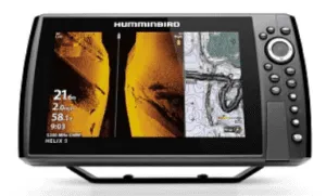
Starting with the Helix series in 5 in., 7 in. and 9 in. screen sizes with keypad controls, these units come with a “base map” that can be augmented with additionally purchased specific Hummingbird or optional Navionics chart SD card.
Moving up is the Solix G3 line of 10 in., 12 in. and 15 in. touch screens with keypad and rotary controls on the right. Within this line, like all other series within the Hummingbird catalogue, there are purchasing options related to transducers and charts.
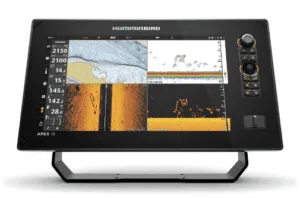
Next up is the Apex line with 13 in., 16 in. and 19 in. touch screen with keyboard and rotary controls on the right. This line offers electric outboard and down-rigger controls on-screen. NMEA 2000, Wi-Fi and Bluetooth connectivity are included. But again, there are no options for displaying wind or water speed information.
At the top of the Hummingbird line is the new Explorer series in 13 in., 16 in. and 19 in. touch screens with keypad controls on the right. Following on the lines of the Apex line with the ability to network on the NMEA system, the Explorer series can be used to control the electric outboard and down-rigger. There is also an in-hull transducer option but alas, no apparent option for wind or water speed.
Online information indicates that the Explorer series is going to replace the Apex and Solix series, but like everything in the electronics world, not confirmed.
*Si-Tex does not provide a MSRP and these numbers are averaged from web site retailers information.
6” 7” 9” 10” 12” 16” 17” 19”
B&G
Vulcan $781 1,116
Zeus S $1,046 $1,782 $3,140
Zeus 3S $3,100 $4,837 $7,566
Garmin
Echomap UHD2 $799 $949 $1,199
GPS Map 723 $1,099 $1,399 $2,799 $4,799
GPS Map 1022 $1,299 $1,999
GPS Map 8412 $2,599 $3,499 $5,499 $7,699
Lowrance
Eagle $769 $1,049
Elite FS $699 $849 $1,649 $2,149
HDS Pro $2,099 $2,599 $3,349 $4,899
Raymarine
Element S $499 $699 $1,199
Element HV $599 $949 $1,449
Axiom + $1,049 $1,240 $1,499
Axiom +RV $1,049 $1,449 $2,699
Axiom Pro $3,153 $4,084 $6,152
Simrad
GO $799 $1,099 $2,299
NSS9 EIO 3S $2,399 $3,699 $5,499
NS0 EVO 3S $6,199 $7,199
Si-Tex
SVS 460 C 4” $449
SVS 560 CF 5” $649
SVS 880 CF $1,300*
SVS 1010 CF $3,300*
NavPro 1200C $2,299
NavPro 900C $1,099
Conclusion
As a first-time shopper for a chartplotter, or if you’re trying to upgrade an older system, the choices available can become confusing. Simply saying, “All I want is a chartplotter,” isn’t going to cut it anymore. Information available on the web, even from manufacturers’ websites, is less than stellar for sailors. The current focus appears to be fishing and going fast in a power boat.
This is where your local distributor/installer rises to the occasion. These are the people with the knowledge that can guide you to what you think you want. Determine your sailing wants, both interest and safety, come up with a budget, and seek out the right people. In many cases the installation may be simple enough that a handy sailor can undertake the task on a weekend. Consulting with an expert does not necessarily mean more expense. However, complex networking may require that expertise. Whatever the outcome, your local distributor/installer is there to support the purchase.
Once installed, and the operating system has become familiar to the sailor, the chartplotter becomes a thing of beauty from a safety perspective. You’ll wonder how you did without it.
As a sailor who has used chartplotters for years, but certainly no expert in the field, I must recognize my local distributor/installer for his capable review and contribution to this article; Jesse McNeil of DeCourcy Group Marine in Nanaimo, British Columbia, a very knowledgeable marine electronics installer, amongst his many talents.


Simrad also offers the Cruise non touch screen models. Chart and depth. A great price point for day sailors and pocket cruisers. Since the main purpose of a chart plotter is to provide navigation information this unit can be a good choice. It is easy to get seduced and then buried in the endless options of more complex gear. Stand alone systems are more fault resistant than deeply networked options. We are seeing a trend away from helm mounted nav pods towards displays at the companionway since more sailors are sailing with a small watch and using an auto pilot. The crew spends less time behind the wheel and a companionway mounted screen is still visible to the helmsman on most boats. The equipment also has more protection from the elements.
All good observations Carl. It all depends on how you’re using the boat, what kind of sailing you’re up to. In our coastal waters the helmsperson tends to be at or behind the wheel (or tiller) due to traffic, navigational hazards and potential debris in the water. With the chart plotter out of reach there is no opportunity to adjust the screen without leaving the helm. In long distance cruising with a wind vane or auto pilot doing most of the driving, your comment makes sense. The sailing world is full of options! Fair winds!
I also went this route and mounted my Axiom on the bulkhead by the companionway of my Sabre 34. I didn’t want a screen in my face while steering. I mounted a remote keypad on the cockpit coaming that is within arm’s reach of the wheel to adjust the navigation screen from the helm. After using it for a season navigating the islands in Lake Erie and viewing AIS information of the freighters in the Detroit River, I have to say the setup has served me well.
Hello Ben. Never thought of a set-up like that. Good idea. And I love the Sabre 34! I was working on one yesterday, finishing up a re-finish of a damaged cabin sole. I too have difficulty with some helms with the chart plotter and instruments in line-of-sight, or just about so. The Navpod systems are great but usually too high in my opinion. On my Islander 30 the chart plotter is low, just above the compass. Thanks for the comment!
Nice and timely article Bert. We just got back from bareboat chartering in the Caribbean and our boat had an all in one B&G plotter that offered all the information one needs in one instruments. The only other item next to it was the autopilot.
In contrast, my boat currently has five separate instruments, all linked via Sea Talk. But my plotter is an outdated Standard Horizon. Plus the instrument pods, one on top of the other, really blocks visibility.
So now I am wondering and asking myself questions… Luckily, like you, I have access to terrific and trustworthy local experts (The Boathouse and Montreal Shipwright)
Hello Marc! I’ve had a Standard Horizon and, most recently a Lowrance Elite 9. I now have a B&G unit that does what I expect it to do and wish that I had all this information before these purchases! I was too stubborn to seek advice, thinking that everything I needed to know was available on the internet. And yes, there is a lot of information out there. I was proved wrong! Live and learn! Thanks for the comment!
I was disappointed that orca was not included. Or even mentioned. Can we look forward to a review of orca?
Hello Donald! Interesting product, and I’ve never heard of it until your mention. Developed in Norway with a focus on the Baltic area, there is no mention of North American installers or support, or even hands-on ability to experience before purchase at a store front. However, it certainly does look next-generation and the direction navigation devices are probably headed in the marine world. Thanks for the heads-up! I’d love to write up a review, but not without at least a bit of hands-on experience. Hey, if you’re up to it, give it a shot! Thanks for the comment!
I use an older laptop that is dedicated to cruising. At home I can update my charts and with the 15″ screen I can plan my routes in advance and just plug it in at the nav station; there, it is held down with Velcro. I can then transfer those routes to a Garmin hand-held GPS that will be located at the helm…I have a backup for that also. Those handhelds are of an older model that were once Garmin’s latest and greatest creation. FWIW, I also carry my newer home laptop on cruises as a backup or for normal household uses. This combination has taken me on round trips to Hawaii, Alaska, and numerous British Columbia visits.
Many cruisers are on a tight budget. While navigation is very important spending thousands of dollars for the bells and whistles that chartplotters provide is not a requirement…they will be outdated next year as you pointed out. Buying two, for helm and nav station, is even more costly.
Thank you for your comment and observation. You make valid points, and they obviously work for you. I sail on a 30 ft boat without a below decks navigation station, no-where to put a laptop. The second strike is being able to comfortably see detail on a small hand-held screen in the rain. And yes, I have done that in the past when the Standard Horizon H2Os first came out. Wonderful little unit, at the time. But this was an article focused primarily on chart plotters. As it turned out, it was almost too long anyway. If I was to explore all the other electronic options available for navigation I would be at the laptop (no pun intended!) for weeks, instead of going out sailing! Spring is here! Time to get out on the water! Have a great sailing season (it sounds like you’re in the Pacific NW somewhere).
You raise a good point concerning smaller boats. My previous was a San Juan 28 with tiller steering where I used a Garmin 45 GPS and, later, with laptop computer charts. You have to be creative to make everything work out.
I would also like to see a PS review of tablet based systems like Orca and Sailproof as well as wireless instruments like Calypso.
Thanks for the comment Roy. As indicated to Mr Kendrick earlier, the electronic world is changing rapidly. I’ve never heard of Sailproof or Calypso. For this article I focused on what was available commercially in North America (specifically, my small part of North America), plotters I could get my hands on for a review. Your request has merit and is probably where the electronic world is going anyway. I suspect that our readers would expect a hands-on style review and not just regurgitation of manufacturers advertising. But a review of that nature is going to be a major undertaking on the part of PS. But it could happen……..
Nice write up. While waiting for the furuno XL plotters to be released, we installed two sitex Navpro 1200 units and a Sitex 762 stand alone radar. The navpro units are very basic and well behind the times. A number of instances, in fog to make matters worse, has the networked Navpro units freeze up only being restored to operation by turning off the circuit breakers they were powered by. No explanation from Sitex on that. Our current Furuno system is two 13x plotters, one 10x plotter, NXT radar, B265 transducer as well as two encoder knobs to remotely control two of the plotters. The furino XL system is light years ahead of most everyone else and furuno caused much consternation taking so long to release the system but the wait was well worth it. Charts are exclusive to furuno, purchased via WiFi, and offer all sorts of features not available from Navionics or C map. As you’ve said, there isn’t sailing features on the furuno software, that I’ve found anyway but on screen weather from our maretron W200 shows what we need, plus furuno has proprietary weather forecasting and current conditions via satellite by subscription. I believe this system will be at the forefront for several years as the computing power of the units is quite high, they are automatically updated via WiFi and the hardware is robust.
Thanks for the comment Russ. Yes, I’ve also had Lowrance and B&G units freeze up with the only alternative being to shut the units down at the breaker. At least with the Lowrance the whole screen froze and it was pretty obvious. On the B&G only the chart screen froze, the digital numbers kept displaying and changing. A frightening experience in the fog of Juan de Fuca Strait on a return from the west coast of Vancouver Island.
All good information on the Furuno system. I’ve never used one on a boat, only at the shop display and so have limited knowledge and experience. It sounds like you have quite the integrated system that’s working well for you! Thank you.
Good article, Bert. I replaced all of the electronics on our Jeanneau 37 last year with Raymarine. The chartplotter is an Axiom+ 12 bundled with a Quantum radome. On sale at $ 3,500 vs. $ 2,900 for the chartplotter alone, getting the bundle was a no-brainer. The boat had an old Raymarine 435 chartplotter at the nav station below decks. I was able to replace the 435 and cover its mounting hole cheaply and effectively by using an older iPad connected to the Axiom+ through WiFi using the RayRemote app. The Axiom+ also lets me control our Fusion stereo from the helm.
Ive been very happy with Raymarine’s connectivity and customer service. The A-95 on our previous Jeanneau started freezing up after its warranty expired. I returned it to Raymarine. They said it could be repaired but said its CPU would always struggle with the amount of data on modern charts. They offered a new Axiom+ 9″ MFD at half price. I accepted and they threw in a flush mount adapter and remote card reader at no charge.
You have to like it when manufacturers stand behind their products. Did you go direct through Raymarine or through a local distributor? That sounds like a really good deal for the bundle and, considering the performance of the new generation electronics vs the previous old stuff, the results are well worth the money. I wonder what we’ll be saying about our current equipment 10 years from now?
Thanks for the comment and information James. Have a great summer on the water!
I dealt directly with Raymarine customer support. They were always very responsive.