Not long ago, stand-alone marine electronics, like chartplotters or depth sounders, were superior to any sort of combination unit. Today, that’s simply no longer the case.
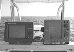
Most marine electronics manufacturers package even their most capable products in some form of combination unit. This reduces overall price to the consumer and minimizes required mounting space—both are real benefits to the small boat owner.
A trickle-down effect (this one actually works) caused by the rapid advancement in electronics has also proven to be a boon to boaters.
Here’s how it works. As the capabilities of top-of-the-line products improve, features once present only in the most expensive gear are soon relegated to what we like to call, “second-tier technology status.” Then as each new feature is introduced into a manufacturer’s flagship product, the second tier quickly finds its way into less expensive gear.
What We Tested
Lowrance’s LCX-19C started life as a top-of-the-line, color depth sounder. When marketed as a combination chartplotter/sounder, it’s packaged with additional hardware, including a GPS antenna. Also included is hardware and software that allows data transfer between the unit and your home computer.
Competing head-to-head with the Lowrance is a unit supplied by Japan Radio Company, the PLOT 500F plotter/sounder combo. Both units are cartography capable and were so equipped for testing. Navionics and C-Map loaned us map-cards of South Florida for testing.
How We Tested
We used a portable base made from a section of wood to mount the pair of combo units side-by-side for testing. This allowed us to move our test rig as needed from our shop to our test boat.
Viewability played a major role in our conclusions, and was rated under a variety of conditions ranging from bright sunny daylight to dark nighttime lighting. We determined the day-view rating by looking at the screen from various angles, with and without polarized sunglasses, using several different background color palettes, and from various sun angles. After our day-view testing, we waited for the sun to drop and then gave each unit a night-view rating.
We took both units to sea on our test boat and evaluated their sounder capabilities over known bottom structures. We used the same transducer to test both—an Airmar B44V 10-pin thru-hull tri-ducer—permanently flush-mounted in our test boat. Airmar crossover cables allowed us to attach the 10-pin connector to the proprietary transducer connections on each of our test units.
Both sounders were rated in shallow water by cruising a channel with depths ranging from 10 to 20 feet, as well as idling up a hard rock ledge that terminates in a depth of three feet. The channel contains several pieces of hard bottom structure that added to the evaluation. For deep-water testing, we rated each unit by making several passes over a steel wreck in 125 feet of water. All testing was done in 80° salt water.
The plotter and sounder sections of each unit were rated for user interface based on each unit’s dials, buttons, cursor pads, joysticks, and software. Each plotter/sounder combo was supplied with its own GPS antenna that was connected to its respective unit during testing. Both antennas were mounted to a short piece of wood and fastened to the upper deck of our test boat to maximize satellite reception. While testing in our shop, we simply placed the antennas outside as far from the building as possible.
JRC PLOT 500F
The PLOT 500F came with an external self-contained WAAS GPS sensor and an integral 600-watt sounder. An optional DGPS sensor is available, but we did not test it. The unit contains an internal world map and uses C-Map cartography to enhance map details in the area covered by the card. Overall dimensions of the display unit are 8-1/4″ x 7-1/4″ with a depth of 5″. Diagonally, the screen measures 6-1/2″ and has a resolution of 234 x 320 pixels in a portrait layout.
Ten levels of control are available for screen brightness and contrast. The unit can be mounted on the supplied metal bracket or flush-mounted using threaded holes on the back panel. We bracket-mounted the JRC on the test board and found the installation to be easy and straightforward. One glitch we noted was the failure of the power cable twist lock to hold fast.
The JRC garnered a Good rating for daytime viewability. Though it lacks the fine details of the Lowrance display, it is brighter, and far less reflective.
In addition, with its larger font size for names and depths, the JRC is much easier to read underway, we think. The JRC darkens very little when viewed with polarized sunglasses, but darkens substantially at angles beyond 45 degrees and the screen appears blank beyond 60 degrees.
The JRC earned a Good rating for nighttime viewing. Screen brightness is adjustable over a wide range and dims lower than the Lowrance. Pushbuttons and other controls are backlit at a single setting and on at all times when the unit is powered.
Many common functions on the PLOT 500F are controllable from dedicated pushbuttons or via the four soft keys, thus minimizing the need to enter multi-layered menus. Waypoints can be saved at the boat’s position with the joystick or the MOB key.
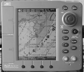
Scrolling through number, letter, and symbol lists—a slow and tedious process—is the standard method of manual waypoint data entry on the JRC. On the JRC website, NAVLINK software is provided for free downloads. This Windows-based software will allow PLOT 500F users to upload, download, and edit (with text editing software) a waypoint and route list. How-to details and cable requirements are on the website. We did not attempt to download or use this software.
Screen redraws on the JRC can be slow, sometimes taking up to five seconds to totally redraw the map after a range change. However, unneeded map display data can be reduced by the user, and we’d expect this to speed the pace of redraws. JRC has incorporated an adjustable length course predictor in the PLOT 500F software. We find the addition of this line a real step forward when compared to the small boat-shaped pointer found on the Lowrance unit. A recently released software upgrade adds a “Go To” soft key when operating in the plotter mode.
The 600-watt sounder integral to the PLOT 500F is full-featured and includes a dual-frequency transducer (50/200 kHz), variable range marker, zoom, bottom zoom, bottom discrimination, A-scope, Shift, and water temperature display. Gain level can be adjusted by pushing the gain button and turning the “Jog-Dial.” We always like to see a rotary knob for quick manual gain adjustments.
One feature on the JRC sounder we especially like and have not seen on other sounders in this price range is the 5-foot stepped manual depth ranging. That means the depth is adjustable in 5-foot increments from 0 to 5,000 feet—a feature usually only found on far more expensive machines. We rated the JRC Good in both shallow and deep water and Excellent for its Sounder User Interface. Minimal gain was needed at the deep wreck, which in our view means this powerful sounder should have no trouble with depths in excess of 1,000 feet.
We found the JRC on the web for $1,399 when equipped with a GPS112W sensor. The warranty is two years on parts and one year on labor.
Bottom Line: We especially like the intuitive sounder controls on the PLOT 500F. Its new “Go To” soft key is a plus, and it betters the Lowrance in these areas: daylight viewability, price, and parts warranty.
Lowrance LCX-19C
The LCX-19C can be purchased as a standalone sounder or with the $299 GPS mapping package. This turns the sounder into a complete chartplotter/sounder combo unit. The mapping package also includes a GPS antenna, Windows-based MapCreate 6 software, a blank 16MB multimedia card, and a USB card reader.
Lowrance uses a landscape layout on the LCX-19C, making for a slightly wider unit. It measures 9-1/4″ wide x 6-3/4″ high and only 3-1/2 deep. Though the Lowrance screen is slightly smaller diagonally than the JRC—6-3/8″ vs. 6-1/2″—it has over twice the resolution—640 x 480 pixels.
Eleven levels of adjustment are available for both screen brightness and contrast. Like the JRC, the Lowrance comes with a mounting bracket and threaded holes in the back for flush-mounting. We bracket-mounted the unit for our tests and rated installation Good.
We rated the LCX-19C only Fair for daytime viewability. Though it shows very fine detail in strong sunlight, it is not quite as bright as the JRC screen. Other problems with the screen are also evident. Reflectivity is high, and when viewed with polarized sunglasses, the screen changes from red to green depending on viewing angle. At side angles beyond 60 degrees, the screen appears blank. Viewed through polarized sunglasses, it blanks beyond 45 degrees and darkens slightly from all angles.
The map and sounder details on this chart are best viewed straight in front of the display and at less than three feet, in our estimation. Any farther and the details were too small to see for us. We used both the normal and high-contrast color palettes to test the daytime viewability.
Adjusting the color palette to night view had no affect on the map colors, only affecting the menu and sounder screens. Backlighting was even over the entire screen, which earned the Lowrance a Good nighttime view rating. Even at its dimmest, it’s a bit brighter than the JRC. Like the JRC, panel lights are on at all times at factory set levels.
To make a change to an item displayed on the screen, like gain or depth, or to select a route, you must select an item on a menu line. Only Zoom and Waypoint have dedicated buttons. It’s not hard to operate a unit in this manner, but it takes longer than with dedicated buttons.
To save a waypoint at the boat’s current location, press the WPT key twice. That’s easy enough. To enter large numbers of waypoints, it’s best to use the provided software and enter the data in a home computer, then transfer the list via a memory card to the LCX-19C. Pressing both zoom keys at the same time activates the MOB feature; this marks a waypoint and shows a course back to it.
Chartplotter map details are extensive, but can be difficult to read easily because of their small displayed size. We preferred the “north up” mode for the map display. In that mode, the displayed map is steady and screen redraws are lightning fast both as the boat moves or as range changes are made.

Minimum range on our test unit with full screen map displayed is only a half mile. Beyond that range the message “overzoomed” is displayed and all map details disappear. Lowrance spokesman Steve Wegrzyn explained this was likely due to Navionics electronic chart limitations saying, “Zoom range is limited only by the electronic chart product used, and not by the performance specifications of the unit.” Navionics concurs, but added that in certain ports the map data will zoom to an eighth of a mile.
Not as feature-rich as the JRC sounder, the Lowrance depth finder still has dual frequencies (50/200 kHz), 375 or 1000 watts of output (depending on the operational mode), zoom, A-scope (monochrome to the JRC’s color), and water temperature display. Manual gain is adjusted by line selecting a menu item and adjusting up or down with the cursor pad—not as user-friendly as the rotary knob on the JRC, in our view.
Depth selection can be left in auto mode or adjusted manually to one of 16 preset ranges.
We gave the Lowrance Sounder User Interface, Shallow, and Deep-water all Good ratings. However, we found using manual gain improved performance at either depth.
Because of the high resolution, fine details of submerged objects are displayed. For us to see these details well, we had to remove our sunglasses and get closer to the screen. Determining details from a distance in a rough water will be difficult.
At West Marine’s online store, we found the Lowrance LCX-19C with the optional GPS mapping package at $1,648. It carries a one-year warranty on both parts and labor.
Bottom Line: In our opinion, this is a decent machine. It performed well overall, but is slightly lacking in daylight viewability and sounder features. Plus it’s a few hundred dollars more than the JRC.
Conclusions
The JRC has twice as many controls on its face—and we like it that way. It makes both the sounder and plotter easy to use.
We like the recent software upgrade on the PLOT 500F; it dedicates a soft key to a “Go To” function when in the plotter mode—a valuable addition. The JRC’s daylight viewability proved superior to the Lowrance. The brighter backlighting on the JRC makes it easier to see the screen, and the larger font used for depth numbers and names makes both more readable. We found it difficult to read the small font on the Lowrance screen when our test boat was getting tossed about by two- to three-foot seas.
We’d take the JRC over the Lowrance and save a few hundred bucks in the process.
Also With This Article
“Value Guide: JRC vs. Lowrance”
Contacts
• Japan Radio Company (JRC), 206/654-5644, www.jrcamerica.com
• Lowrance, 800/324-1356, www.lowrance.com


