Pinpoint navigation is a pipedream that the industry has been silent about for way too long. Just read the I accept contract on your multifunction display (MFD) screen, and youll run across phrases like electronic charts are inadequate as a primary means of navigation. Or, if you don’t believe the chart makers disclaimer, just listen to what the U.S. Air Force, the owner of GPS, has to say about a system that was never intended to be a standalone navigation alternative. And yet thats just what we recreational sailors have accepted it as.
The attraction has been magnetic because GPS, MFDs, and digital cartography, though not perfect, have been a big step forward in navigation. The pure and simple fact is that its a fantastic aid to navigation-not a replacement of the navigator.

Airlines use GPS as an important part of their approach to navigation, but have tuned up the systems accuracy with the implementation of a wide area augmentation system (WAAS). This system uses a set of ground-based sites that receive GPS coordinates and compares them with their high accuracy surveyed location. Comparative data is sent via ground-based signal to a master station depicting how GPS coordinates and actual locations coincide. Complex algorithms correct for disparities and send a signal to a set of geostationary satellites that beam a signal back to earth correcting WAAS-equipped GPS units.
A satellite signal quality page can be called up on most GPS units. It shows satellite position, signal strength, WAAS reception, and a useful reference called dilution of precision (DOP) gives a feet or meters reference for the radius of signal accuracy. Occasionally, it is termed HDOP, or horizontal dilution of precision.
Regularly checking this reference to fix accuracy is important, especially if you are off the beaten path in parts of the world where WAAS coverage does not exist, and GPS satellite coverage may be less than optimum. Its also a good idea to double check the signal quality page before attempting any tricky entries to harbors in dark or overcast conditions. Using you plotter along with radar, depth sounder, and available lateral marks and other nav aids is a sensible approach.
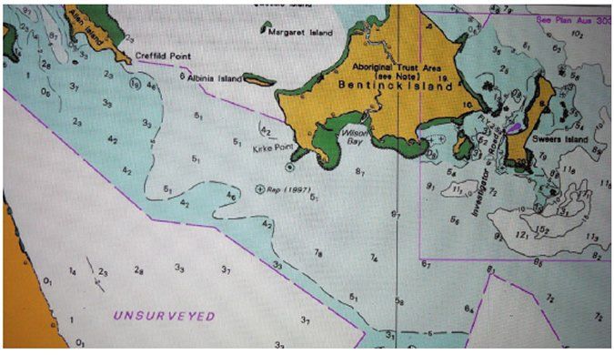
The second source of navigational uncertainty, and an even bigger threat when it comes to putting our boats location and the plotted fix on an MFD screen, has to do with chart accuracy. We sail imperfectly surveyed oceans, with bottom features that change over time. Organizations like the International Hydrographic Office are well aware of this issue and have done much to inform professional mariners about cartographic shortfalls. Commercial ECDIS charts allow a user to call up a feature known as the zone of confidence (ZOC). It portrays a charts level of accuracy and is linked to surveys and other chart-making factors.
This accuracy reference ranges from A1 (less than 5 meters off) to D (more than 500 meters off), with U designating unsurveyed areas. The A zones are mostly where deep-draft ships navigated in coastal waters and D zones still pop up here and there in U.S. waters. Such charted waters with greater than 500-meter inaccuracy are plentiful in third-world regions, and remote island areas-in essence, where many long-range cruisers prefer to voyage. What this means is that no matter how accurate your GPS signal happens to be, its only as good as the cartography it overlays.


