

During a recent delivery from Punta Gorda, FL to St. Augustine, FL I had the opportunity to compare two routing apps, one of them recently updated—Weather 4D and Luck Grib, which we introduced in our recent report on satellite communication at sea (see “Weather Routing with Iridium Go,” May 2020) and one of our favorite routing apps PredictWind. Weather 4D is intended to be a very robust all-in-one program that performs three essential functions; chart plotter, GRIB download/viewer and weather router. As of this review there is no product that performs all these functions.
Half-way through writing this article, Luck Grib notified us of a new version of their software that provides all the same functionality except chart plotter. Instead of evaluating the two products separately, this article will compare and contrast the two, with the noted difference of the chart plotter feature. The best of the two was used on a Punta Gorda to St. Augustine delivery of a Sabre 386. As Capt. Ron of eponymous film fame puts it: “If anything is going to happen, it’s going to happen out there!”
The benchmarks used to evaluate 4D’s chart plotter functions were Navionics and iNavx apps. For GRIB handling and routing, the two apps were compared. Before we get too far along, I need to emphasize this caveat: It is important to remember routing software will never relieve the vessel’s master of the responsibility for planning. The software provides a valuable second opinion.
Loading 4D and LG onto the iPad was straightforward. The challenge is loading 4D’s cartography (charts). First, the cartography is a separate annual subscription. For a NOAA subscription the annual fee is $35. When loading charts, one goes to Global Settings>Navigation>Maps Settings> where there are abbreviations for various chart providers.
Weather routing requires the vessel’s polars, or at least a generic polar that is close to yours. The version of the 4D program we tested had four polars pre-loaded, including a First 31.7, X37, and a Hanse 495. We attempted to load different versions of the polar for my Tartan 33 and had errors. Because 4D does not include a polar editing feature, we could not adapt one of their polars for our test boat.
LG uses a different approach. From the initial drop-down menu, one selects the “Routing” option. This brings a sub-menu where you define a vessel. We added our boat, then I went to the “Sailing Polars” menu where we imported the same file that was rejected by 4D. Had we not wanted to import the polar, or if we did not have a polar,we could have gone to the “Sailing Polar Diagram Catalog” option. The LG polar catalog lists about 100 different vessels.
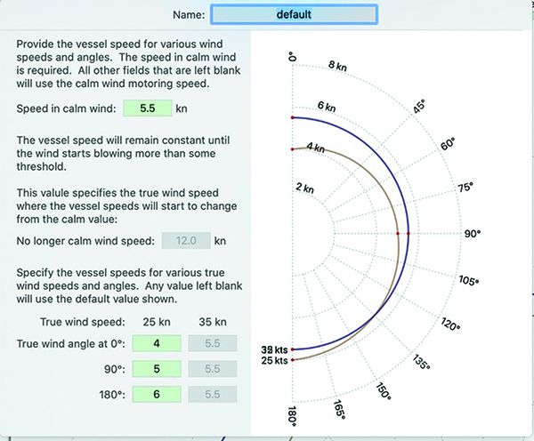
Motoring polar
LG also offers a “Motoring Polar” menu. For those not familiar with the concept of a motoring polar, every boat operates differently under power. Also, when hopping across the bay, you may run at 2300 RPM, but on a crossing you would run at 1800 RPM to save fuel.
The user enters into an input screen the following information, calm air boat speed, boat speed with 25 knots and true wind angle (TWA) of 0, 90, and 180 degrees, and boat speed with winds 35 knots and TWA of 0, 90, and 180 degrees. This importance of this feature was made clear in our sea trial of the product.
Neither LG nor 4D track GPH, or cumulative fuel consumption. The ability to compare that to allotted tankage, would be a great planning tool. For example, if the model forecasts 80 hours of motoring and, based on user input, the vessel burns 0.75 GPH and the tankage is 60 gallons, then you know that either additional fuel is needed for a safety cushion, or you will need to sail slowly.

What We Tested
These abbreviations are not well explained. While we may know our local ones, like NOAA and WaveyLine, one is left to search the Internet to determine what charts the other abbreviations provide. Selecting “NOAA” launches a selection page. I initially selected the charts for Jacksonville to Cape Canaveral for downloading. After 20 minutes I aborted a download.
Thinking that was an anomaly, the area from Cape Canaveral south to Marathon was selected and downloaded. This took 50 minutes. While 50 minutes felt like a long time, it is not an objective benchmark.
To benchmark, the same area of charts in Navionics application was deleted on the same iPad. This removed the vector charts, the sonar charts, and other layers of charts for this area. The area from Cape Canaveral to Marathon area was then selected for downloaded in Navionics. The download took 15 minutes on the same network, that download was over 4 GB of enhanced data that Navionics presents in multiple views. Stated differently, it took less than 1/3 of the time, for significantly more data.
Another download comparison was done versus iNavx. Unfortunately, one cannot offload a section of charts in iNavx, nor can one download a section of the East Coast NOAA charts. So, the entire iNavx app was deleted, re-downloaded and then raster charts for the entire east coast of the US, Puerto Rico and the U.S. Virgin Islands were downloaded. Downloading that entire section of charts took 12 minutes, and the Gulf of Mexico charts took about 5 minutes.
Based on these objective standards, the time to download the 4D charts is excessive. Additionally, the server only offered the older style Raster charts, it is not clear if, or how the new vector charts will be supported. Nor is it clear how often these charts will be updated. From experience, my Navionics and iNavx charts find updates every 30-45 days.
I consider myself fairly techno-savvy, and based on my experience 4D does not follow many of the existing conventions and nor are the menus intuitive. Let’s start with something as simple as going to a waypoint. Normal convention is to move cursor and select the desired location using a button or tapping the screen. After the location is selected, a pop-up menu appears with an option to navigate, or sometimes create route to the selected location. Not with 4D.
As shown in the examples (see page 19 “Familiarization is Key to Using Routing Apps”), the menu structure of 4D is cumbersome. Another example of a design issue is changing the charts.
To change charts, one clicks on the center drop-down menu.
This will launch another drop-down menu. Under the “Display Options” section, one selects “Map.” One would normally expect to see only those maps that have been downloaded. Instead of seeing only those charts that are downloaded, one is offered a selection of all charts that are available in the server. The options are presented in no specific order. Finally, if the user selects a chart that has not been downloaded, the app presents a black screen. It would enhance usability if the drop down only offered downloaded charts.
When 4D was connected to the instruments on my boat via the Vesper WiFi, 4D displayed all the sensor information and AIS targets. Unfortunately, the AIS targets are poorly presented. A long press on a Class B target will display Closest point of approach (CPA), speed over ground (SOG), course over ground (COG) and other info, but not the name of the vessel. Nor does it immediately display if the target is Class A or B.
In the real world, these are significant issues. For example, returning from Bimini, on a quiet night crossing of the Gulf Stream one can reasonably expect to counter at least five large vessels. Especially at night, being able to call a ship by its name is much safer and efficient. Being able to call “Knock Nevis, Knock Nevis, Knock Nevis. This is the sailing vessel Road Kill on your bow, would you like a one whistle pass?” versus “vessel five miles off my stern, this is the sailboat Road Kill …” (Since Knock Nevis is the largest vessel ever built, I’d appreciate a little more help avoiding collision.)
Because the 4D’s menus are not intuitive, you really need to use the help system to learn it. One example is that onboard my boat, I connected the device to my Wi-Fi. When I got back home and tried the program, a “disconnect alarm” began. One would think that acknowledging an alarm would be under “Navigation>Alarms” menu. It isn’t. Instead it is under “Settings (upper left corner)>Navigation (not the one on the home screen a different one)>NMEA Settings>NMEA Inputs>Depth- missing data alarm
In summary, I was not impressed with 4D’s ability to act as a chart plotter. There are other products out there that are better at this function. But I did not want to dismiss the program altogether.
Luck Grib vs. Weather 4D
| MAKER | LUCK GRIB OFFSHORE VERSION | WEATHER 4D |
|---|---|---|
| EASE OF USE | Excellent | Poor |
| GENERAL FEATURES | Good | Fair |
| GRAPHICS | Good | Fair |
| PLOTTER | Fair | Fair |
| AIS TARGETS | Good | Fair |
| POLARS | Fair | Fair |
| ROUTING | Good | Fair |
| PRICE | $75 via landline ($125 via Iridium Go) | $50 (not including subscriptions) |
Grib downloader/Viewer
The balance of this article will compare 4D versus the newest version of Luck Grib (LG), and discuss the use of gridded binary files (GRIBs), compressed files that contain weather data.
One good test of routing programs is to see how they handle islands and shallow areas. For the purpose of the evaluation I selected from Ft. Lauderdale to North Caicos and then back. Both programs handled the outbound passage well—although LG did offer an option to sail between Eleuthera and Paradise Island. On the return, both routed across the flats south of Andros.
This is where LG sets itself apart from any other product. The user can add boundaries. These boundaries are treated as no-go zones by the routing software. I set boundaries around the shallow areas in the Bahamas. Once these boundaries were set, the program routes appropriately. The value of this feature cannot be overstated.
On a longer passage, I download weather twice a day and update my routing. By having defined boundaries, I am reasonably sure I will not be routed over shallow water or through an island. As previously stated it does not relieve you of the obligation to check that the recommended routing is safe.
Hands down Luck Grib outperformed 4D in routing and ease of use.
Compared to the streamlined operations found on chart plotters, some of the navigation features on apps that we tested were clunky, requiring several steps to carry out basic function. But it becomes easier as you gain familiarity with all the functions.
- Using Weather 4D, to “go to” a location, one launches the application and then taps the icon on the lower left corner to unlock the screen, thereby allowing the user to pan or move the display area (see red arrows). One then moves the screen to find the destination. Then instead of simply tapping on the screen to select a location, one must tap on the crosshairs in upper right of the screen, this will bring down a drop-down menu that allows various options for the selecting tool. For simplicity, I selected “Center of Screen.” Once the desired destination is under the crosshairs in the center of the screen, one then taps on the rose in the upper left to open one of the two “Navigation” options in the program. This brings another drop down menu, on this menu one selects “Go to target.” In fairness, if you do not change any of the options selected, one can simple center the screen on the next destination, click on the upper right and select a new “Go to.”
- This is where Luck Grib app sets itself apart from any other product. The user can add boundaries. These boundaries are treated as no-go zones by the routing software. I set boundaries around the shallow areas in the Bahamas. Once these boundaries were set, the program routes appropriately. The value of this feature cannot be overstated. .
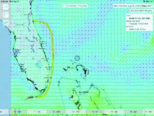
- By closing the weather routing view on Luck Grib, the suggested route was easier to distinguish. This image, sprinkled with wind barbs gives a good view of the planned route. This view clearly shows that swinging east around Cape Canaveral is faster than
following the rhumb line for the given current and wind conditions.

Grib downloader/Viewer:
All GRIB downloaders/viewers work equally fast when connected to the Internet. The real challenge is downloading when connected through an Iridium GO device. Both 4D and LG downloaded a Global Forecast System (GFS) GRIB for our Fort Lauderdale to North Caicos passage in about 90 seconds. But, as in any satellite download, you have to be careful about the size of the file, or amount of data requested. If you keep the download under 46kb, downloads are about the same.
Weather 4D required a second weather subscription for ocean current data. Clearly, any routing app will fall short without this data—particularly one that involves a major current like the Gulf Stream, as mine did.
I am also a fan of having two or three GRIBS to review. One is the large pressure picture that lets me see what fronts are coming—in the winter it is the Canadian lows, in the summer it is the fronts from the north and the hurricanes. If a current is a factor in my routing, having a current GRIB is essential. The ability to switch between the latest local weather, the ‘big picture’ pressure and have ocean currents is a huge. Unfortunately, only Luck GRIB supports multiple GRIBS.
A Satellite Tracking App
While not the primary focus of this review, 4D offers a product called iWatchSat for $15. This app is simply a must have for anyone using Iridium satellite communication. This app tracks the Iridium satellite umbrella and shows coverage for your location. You can see the satellite coverage and know the best time to start a download.
Why is this important? Satellite coverage with Iridium is still spotty at times. I’ve found that I can have good coverage at one minute and three minutes later I will lose it. If you use the Iridium network for downloads or e-mail, this app is well worth the $15.
Help Documents
Since these programs are intended to be used when you are well offshore, the ability to access the help document is critical.
Weather 4D downloads their help to Apple Books app. But if you access their help documents offshore, the Apple Books app gives an error. The work-around is easy, simply close the error dialog box. This will then bring you to the help doc. It is fairly well written and searchable. But the developer insists on making the user suffer through various videos to get answers.
The video is well done, but the speaker speaks slowly and clearly. For example, if one wants to find out how to set a way point, there is no simply list as appears in this article. I admit that because the program does not follow many conventions, the video helped. But there should be a well written text explanation for easier reference. Sometimes, when things are getting weird offshore, we don’t have time or the quiet environment to listen to a video.
Luck Grib uses a hybrid approach. The help document for the routing module can be fully downloaded. In addition, the program has question marks “?” or help tips embedded in the program. This multi-level system works. Because the program is fairly intuitive, there is little need to access the help documents. One criticism of LG’s help documents is that the help document only tell how to use the program. It does not explain how best to leverage its features.
As the computing ability of tablets increases it is possible to do more on them. LG is an extremely robust program packed with features. But the iPad’s screen is still only 10 inches. The program returns extremely useful data, but some of it gets lost in a busy screen.
Only by being “out there” using the program 2-3 times a day to recalculate the route that I became proficient at using it. These lessons are discussed below.
Sea Trial
Based on my at the dock trials, I decided to use Luck Grib to route my delivery. The sea trial was for a Sabre 386, for which I’d need polars.
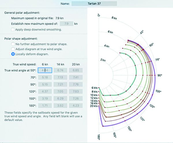
Since LG did not have the Sabre 386 polar, I selected the pre-loaded polars for a Tartan 37. If I wished, I could have modified that polar by entering data in the editing tool. The curmudgeons are saying “huh some test”. Well they are almost correct.
When the owner asked for my Punta Gorda to St Augustine float plan, it was generic. The plan called for us to go out Boca Grande Pass, south to the west end of the Moser Channel, then to Marathon and north to St. Augustine. For the Marathon to St. Augustine leg my plan was pass just north of Sombrero Key Light and follow Gulf Stream to Lake Worth, head for a point 5-10 miles off Cape Canaveral and enter St. Augustine Inlet. As always, my float plan was ‘subject to weather’.
The Motoring Polar
On the actual delivery, the winds were intermittent and light. Not exactly what one would expect to be a good test of a routing software for a sailboat. But, Luck Grib uses a motoring polar, a sailing polar, the downloaded wind GRIB and the downloaded current GRIB to develop it’s routing. The software’s ability to merge all that data was impressive.
To review, the motoring polar (see page 18) uses the “speed in calm wind” as its baseline. I determined the approximate speed the boat will make with a modest fuel consumption. Then I estimated what speed the boat will make as the wind picks up. This is not precise. Through careful logging, a vessel owner could develop an accurate motoring polar. But for a delivery guy, this approach works.
Because the winds were so light, and because I factor in a large cushion, we ran at a fuel sipping 1600 RPM for all but the last six hours of the run. Even at this slower speed, we completed the Marathon to St. Augustine leg in 2 days 4 hours. When we apply this time to the shortest course over ground distance of 360 nautical miles, our ‘effective average velocity,’ which sailors call velocity made good (VMG), was 6.67 knots at 1600 RPM. Not too shabby!
How did LG do that? The program takes data from the sailing polar, the motoring polar, the Ocean Current GRIB and the GFS GRIB and then develops the most efficient routing.
Using GPX Data
The next step in using a routing software is applying the result or following the route. It is possible to export the LG route as GPS exchange format (GPX) data, download the GPX data to the chart plotter, and then have the chart plotter direct the autopilot. If the iPad or Mac is integrated into the boat’s data network, this is fairly easy. Without having your iPad or Mac fully integrated to the vessel’s chart plotter and/or autopilot there are several steps that need to be taken. I am not sure the effort is worth the enhanced efficiency.
A more efficient way to use routing software is to follow the concept of the routing. This requires the user to understand the hows and why of weather routing. Understanding weather routing begins with a careful review of the current and wind GRIBs to understand what the program is trying to accomplish. Based on that review, a waypoint is set 4-6 hours ahead of the boat, or at the next major turn, and we lay for that location. Often reaching that waypoint requires dodging vessels or pop-up storms.
Offshore we download new weather GRIB files twice a day. On coastal runs we download whenever we regain cell coverage. Either at a waypoint, or after a download we move the starting point to the vessel’s current location and run a new routing. In this manner, any inefficiencies are minimized. While purist will eschew this process, on a delivery it ensures we are running as efficiently as possible.
Re-running the routing is simple, click on the location mark on the top-center of the screen, and the vessel’s current location is presented on the display. One moves the routing start point to there, and the APP recalculates your routing based on where you are.
You’ll be surprised how frequently the fastest route is not the rhumb line, or even the route you thought would be the fastest.
The Luck Grib displays windless areas in purple shading. These areas are zones where you can expect to motor. Because our run was a delivery, we motor-sailed the entire run and had speeds of over 9 knots in the Gulf Stream.
Conclusion
This brings us to the summation. What’s on my iPad for a delivery? I will continue to carry Predict Wind as it is the only product that uses the full European Model for weather routing. But, Luck Grib is becoming a very formidable product.
The ability to support multiple GRIBs and recalculate without connecting to the server via satellite is huge. This feature allows us to recalculate using existing GRIBs based on the vessel’s current location, maximizing our velocity made good. Finally, my iPad now carries iWatchSat so I can track the Iridium satellites and only do GRIB downloads or fetch emails during best coverage periods.
The cost for Luck Grib is $25 for the base application, $50 for offshore module that allows for the satellite downloads and $50 for routing. If you do not plan on using the satellite feature the cost is $75 for the product- quite reasonable! If heading offshore $125 is downright cheap
For recreational sailors, the new Luck Grib routing app is an incredible value. Experienced sailors can confirm their routing, and even seasoned sailors can see how what they thought was the best route, isn’t. All of us, including me! Can hone their routing skills by using a weather routing tool such as Luck Grib.
USCG Capt. William Herrmann (www.uscgmaster.com) is a delivery skipper and an American Sailing Association instructor.


You could start the article by mentioning that the software compared will not run on Windows or Android, and indeed Weather 4D won’t even run on a Mac. This would have saved me the read and interest in the story, and the frustration at having to figure it out.
It also would have been great to have at least a sidebar to compare it to the OpenCPN grib plugin (which unlike the products compared runs on a variety of platforms).
You need to check out Sailgrib on Android. I have used it on multiple Ocean races, including winning Annapolis to Newport, using it on my Samsung tab active tablet and comparing to Expedition routing on the boat pc. Very similar routes in each app.
No other program does all three functions?Guess you haven’t checked out Expedition software, which does all three and more. And more better too!
Dale,
My apologies for the delayed response. I was on a delivery and was told someone was replying to queries.
I just finished an on-line review of Expedition software, as I was going to buy it for my racing and deliveries. Expedition has some unique features that are great tools for racers. While it does provide routing, my reading the Expedition Marine website indicated one had to I port the GRIBs. I did not see where Expedition offered the various models that Predict Wind does. Notably, the full European Model.
If I do buy Expedition it will be for crunching data after a race or perhaps during a race.
But on deliveries, I will still rely on Predict Wind Pro.
Bill
Please forgive typo— should be “one had to import the GRIBs.
Contacting Editor to… edit
iWatchSat is an iphone ONLY app. 70% world uses Android. Telling use would be helpful information.
Jeff
Sorry for the delayed response. I was told that someone was covering these wheel I was on a delivery. I am sorry that there is no Android version. FYI per statista.com 53.66% of the world is on iPhones and 46% on Androids.
In future reviews, I will check to see if Android versions are available
Bill