

On December 1, 2020 Kevin Escoffier was plucked from a life raft, near the infamous “Cape of Storms.” The name dates back to 1488 when the Portuguese explorer Dias rounded the promontory. Dutch sailors called it Stormkaap, but a more optimistic King of Portugal renamed it the Cape of Good Hope. Weather systems have ignored the edit, and for many sailors, including Escoffier, it’s where the battle with heavy seas is won or lost.
This story of survival is a two-track-tale of seamanship and the role played by the right equipment. In April we focused on the seamanship side of the story. This month we look at Escoffier’s rescue as a sea trial of some of the latest safety systems, tried and proven equipment, and why the Vendee Globe’s Race Direction team has settled on these specific tools for survival.
Irridium’s Certus satellite service and a Thales Vessel
Link terminal. Sailors had direct-dial satphone number,
giving them constant contact with shore teams.
The Race was originally conceived by BOC Race winner Philippe Jeantot, and over the years the Mt. Everest of solo sailing has become a model of how to prepare for and react to some of sailing’s least desirable challenges. We stressed in part one of this series that solo sailing flies in the face of International Regulations that stipulate that when a vessel is underway, a person must be on watch at all times. It’s true that there’s less risk of collision in the lonely reaches of the Great Southern Ocean, but other challenges come to the forefront. And risk mitigation has been a major concern of race organizers and competitors alike.
For example, each single-hander must carry two life rafts (SOLAS or ISO 9650 offshore) and two EPIRBS. At first this may seem a bit redundant with only one person on board. But it’s likely a key reason why Escoffier is alive today. One of his two rafts was submerged in the forward portion of the cracked-in-two hull. The other was stowed in the cockpit and ready to deploy.
The communication equipment chosen for the race also proved its worth. The system provided 24/7 position reports that were normally updated every 30 minutes, but could be increased in frequency to continuous reporting. The system featured a direct-dial satellite phone number for each participant, and a customized, limited access website available to search and rescue personnel. It included real time vessel location, a skipper and boat profile, along with photos of the vessel from right-side-up to upside down. There was even a portrait of the skipper in his/her survival suit. The system was GMDSS-compliant and featured digital distress signaling. Secondary distress signaling was provided by the two EPIRBs that were a mandatory part of the Vendee Globe Race equipment list.
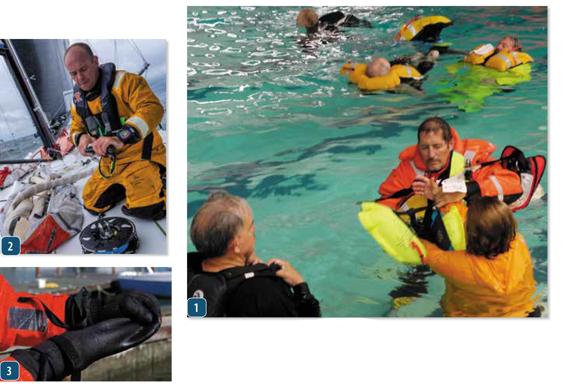
2. Kevin Escoffier’s had multiple drysuits with elastic cuffs to keep water out.
3. Removable, attached mittens allow dexterity needed to don a survival suit.
Tracking the fleet
At the heart of the Vendee Globe’s rock solid communications plan was an across-the-board commitment to Iridium and Thales hardware. This combo lashed together Iridium Certus satellite service and a Thales Vessel Link terminal. Iridium, a major player in sat phone technology, with a recent launch of 66 new LEO satellites, was coupled with a Thales’s broadband terminal—providing a 700 Kbps download rate and a 350 Kbps upload capacity. This increased baud rate delivered faster data handling, Skype video comms capability, 3 lines of voice comms and a whole host of additional advantages used to stay in touch and track the fleet. The system also allowed crews to maintain contact with shore-based teams.
Each day’s sailing action could be shared with media outlets worldwide, and when it came to Escoffier’s rescue, it gave Kevin a chance to double down on his mayday messaging. Within just a few minutes of his boat breaking in two, his EPIRB was emitting a digital distress signal picked up by the COSPAS/SARSAT system. And he had immediately followed up with a memorable Iridium/Thales message sent to his shore crew in France: “I need assistance. I am sinking. This is not a joke.”
A key feature of Iridium’s 700 L-band satellite communications system is its pole-to-pole, worldwide coverage. The system is now part of the Global Maritime Distress Safety System (GMDSS), and one of the major values of L-band communication is much less negative influence from weather related interference.
Thales initially developed durable communication terminals for the commercial fleets and the navies of the world. The new Thales Vessel Link connects to satellite communication equipment and, depending upon baud rate, provides a wide range of communications capability.
The Vessel Link/Iridium Certus combo wirelessly links to Android or iOS devices and allows up to 12 individual phones to be connected. The system provides, voice data and video connectivity. Vessel tracking, weather information and fleet wide info updates are all part of the package. During the Escoffier rescue, the Iridium/Thales terminal became a vital tool in rescue coordination. It tracked and provided communications with all four single-handers involved in the SAR effort. And when the Skype feed from single-hander Jean Le Cam’s cabin camera revealed two sailors on board, everyone breathed a sigh of relief.
for the cruising sailor when sinking is imminent: alert rescue agencies; activate locator
beacon; protect against exposure; and launch life raft.
2. Escoffier’s rescuer Jean Le Cam spotted a low-wattage life raft beacon like the one
shown in the photo, an example of lights we evaluated during PS testing.
3. Some of the personal MOB lights we tested in 2019 had strobes more brilliant than
the one that led rescuers to Escoffier’s life raft.
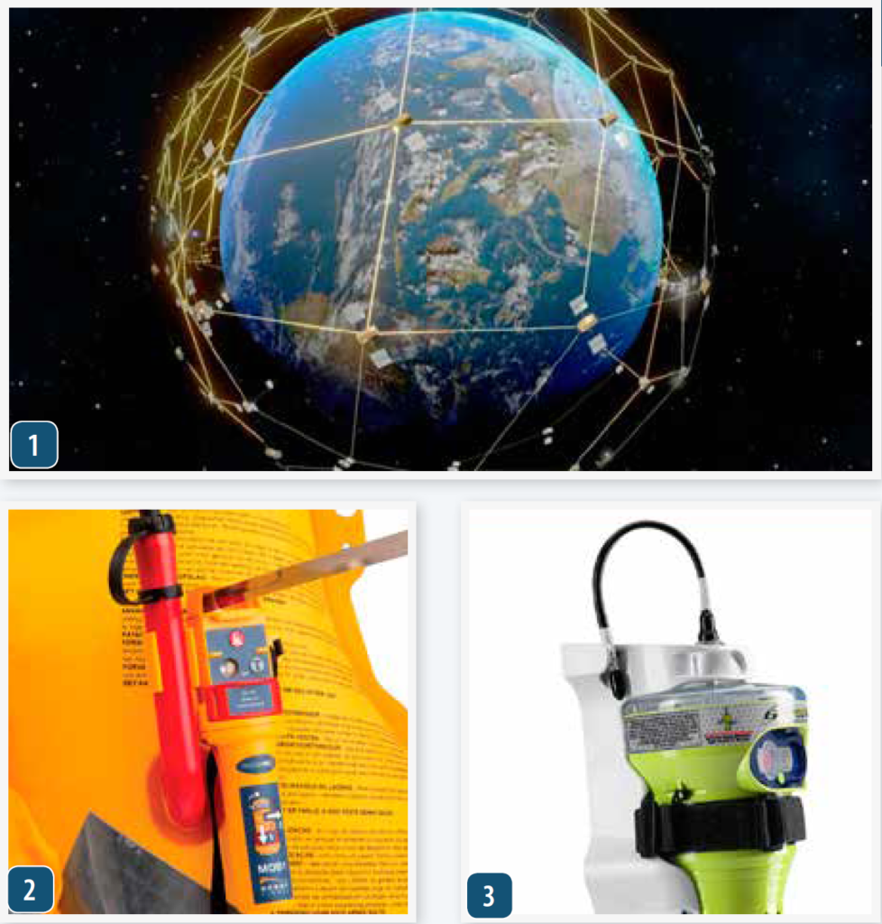
EPIRB signal detecting satellites are part of a multinational Global Maritime Distress Safety System (GMDSS). In the US, NOAA manages and coordinates the Search and Rescue Satellite (SARSAT) program. NASA designs, builds and upgrades the technology. And the EPIRB monitoring electronics package piggybacks aboard GOES and other types of weather, communications and navigation satellites.
Over the years, a continuous effort has been made to increase the accuracy and expediency of detecting and locating broadcasts from 406MHz beacons. Last year, in the US, there were 302 rescues aided by SARSAT beacons (EPIRB, ELT, PLB). The breakdown includes 215 boaters/mariners, 75 PLB users and 12 in aviation incidents. Since its inception in 1982 COSPAS/SARSAT has aided in the rescue of over 48,000 people worldwide including 9,391 people in the United States.
Satellites are arrayed like a three layer cake. At the very top are the geosynchronous satellites (GEO), located about 22,000 miles away from the Earth. They remain constantly in view of a specific region of the Earth’s surface by revolving around the Earth in sync with its rate of rotation. This geometric relationship, results in no discernible relative motion difference between the beacon and the satellite. Therefore, position location via Doppler effect calculation is off the table.
This means that GEO satellites provide ID details of a vessel’s EPIRB , but no position information. This all changed when EPIRBS were turned into “GPIRBS,” through the addition of a GPS receiver. Now, stationary GEO satellites capture position fixes and downlink to a local user terminal (LUT) at the beacon’s location.
Low Earth Orbiting (LEO) satellites follow a circular pole-to-pole orbit, aligned about 99 degrees to the equator and at a much lower altitude (about 530 mi). They rotate around the Earth at blistering speeds and the lower altitude means a smaller circumference to their orbit—one complete rotation takes about 100 minutes. This means that any EPIRB signal entering its cone of coverage will be affected by the approach/departure based Doppler effect that causes a detectable frequency shift and can be converted into position coordinates. The downside lies in the fact that lower altitude results in a narrower cone of coverage, due to closeness to the Earth. Another downside is the need to, at times, store a signal because there’s no ground station available. This store-and-forward relay function can cause delays of many minutes, even hours, in remote oceanic regions where Local User Terminals LUTs are few and far between.
A new system, the MEOSAR satellites has been launched as part of the Global Navigation Satellite system and there was room in the trunk for a COSPAS/SARSAT electronics package. They orbit about 12,500 miles away from the earth and provide a seven times larger footprint on the surface—resolving several prior system ailments. These new satellites utilize a “bent pipe” technology that works like a mirror, continuously beaming down received signals to land based user terminals (LUTs).
When all 72 MEOSAR equipped satellites complete the constellation, there will be four satellites in view at all times. In addition, these satellites share data with each other and downlink to multiple LUTs. This means that position fixing via EPIRB, ELT or PLB distress signals can be accomplished via Doppler calculations, GPS fix or by trilateration (time-based ranging) of signals from multiple MEOSAR satellites. They eliminate the store-and-forward delay found in LEOSAR satellite technology. MEOSAR satellites that carry EPIRB detection hardware include GPS-III (USA), GLONAS-K2(Russia) and Galileo (EU). The net result is shorter fix time, faster processing and quicker rescue responses.
Once the satellite(s) does its job, ground stations spring into action. First in this rescue chain are the local user terminals (LUT) that downlink and decode the data. They determine the beacon ID from its hexadecimal code and its position before passing it along to an appropriate Mission Control Center(s) (MCC). These belong to specific nations or regions and it’s where key questions such as who will take the lead in coordinating the rescue are made. Proximity to the beacon location usually takes priority.
The MCC relays all pertinent information to a rescue coordination Center (RCC), and they determine the best means by which to effect a rescue. If the beacon is in US waters, the USCG is the RCC. In remote parts of the less developed world, where SAR assets are limited, multiple RCC centers may play a role.
In the case of Kevin Escoffier’s rescue, the RCC role was led by Race Direction located 8,000 miles away. They interfaced with France’s SAR center, Cross Griz Nez and MCC South Africa. Race Direction collaborated with weather/oceanography experts at Meteo France and provided the organizational and position guidance to the four Vendee Globe competitors involved in the search.
Feedback from those involved in the EPIRB based search for Escoffier, indicated that beacon position reports jumped around a bit. This was probably due to sea state the and fact that the small
antenna and deep wave troughs are a poor combo. However, the fixes did seem to fall within the 3.1 mile constraint of the MEOSAR goal.
Most EPIRBS are designed to be placed in the water and securely tethered to the life raft with the attached lanyard. This way the water plane acts like a massive radial improving antenna efficiency. The reluctance of someone in a life raft to toss a beacon overboard is understandable, but there are a couple of signal dampening issues that must be considered. First of all a human body situated between the beacon and the satellite will decrease the signal, so will tilting the beacon and angling the antenna away from the vertical. So if you chose to hug the beacon instead of launching it, keep the antenna vertical and above those huddled in the raft.
pole, worldwide coverage.
2. The AIS distress beacon is relatively new to the sailor’s distress alterting toolbox. It
should not be confused with the personal locator beacon.
3. Modern EPIRBs can take advantage of the newest improvements in the satellite
networks that allow for more precise position finding.

EPIRB update
The emergency position indicating radio beacon (EPIRB) has a long history of success. This satellite based distress messaging system grew out of aviation’s use of emergency location transmitters (ELTs) that broadcasted on 121.5 and 243 MHz. In 1979, a plane was lost in Alaska with two Congressmen on board resulting in the development of an ELT that became the predecessor of today’s beacons. Aircraft still monitor these frequencies and act as relays when a signal is received. But in 1982 a multinational organization was formed (COSPAS/SARSAT) and geostationary satellites were used to detect signals. Today EPIRBs, ELTs and smaller personal locator beacons (PLBs) operate on a primary frequency of 406MHz, but also transmit a weaker 121.5MHz signal for final SAR homing. The latest COSPAS/SARSAT electronics packages are housed in geosynchronous (GEO) as well as low earth orbiting (LEO) and recently added midlevel earth orbiting (MEO) satellites, all listening for 406MHz signals. The beacons emit low wattage bursts of RF energy and thanks to major advances in digital technology, antenna design and receiver sensitivity and selectivity, these satellites and beacons have become a major player in GMDSS.
Originally, EPIRB signals were detected by an array of high altitude geostationary satellites, each covering a large portion of the Earth’s surface. One signal burst could yield the ID of the vessel in distress, but it took multiple signals to calculate an accurate fix. A switch to 406MHz beacons and the addition of Low Earth Orbit (LEO) satellites greatly improved performance. Eventually, GPS receivers were built into EPIRBs and the emergency signal included a GPS derived lat/lon position. Along with the built-in GPS came better ways to check the readiness of the beacon. Most manufacturers provide battery test features, while some also incorporated signal propagation testing capabilities.
The most recent upgrade of EPIRB beacons coincides with a new array of Medium-Earth Orbit Search and Rescue (MEOSAR) satellites that circle the Earth. The new EPIRB system utilizes the EU’s Galileo constellation of navigation/SAR satellites along with the US GPS-III and GLONASS- K2 Russian system. This addition of 72 MEOSAR satellites helps to determine EPIRB location more quickly. The system’s new goal is to be able to locate an EPIRB within 3.1 miles, 95% of the time within 10 minutes. Plus the new satellites add a message forwarding capability that lets the sender know that their distress signal has been received.
Some of the latest EPIRBs also include AIS signal transmitters that add another valuable homing alternative. It’s interesting to note, however, that Escoffier’s personal AIS transponder did not aid in his location, but what did play a crucial role was a simple battery and bulb series circuit that comprised the fixed light glowing at the peak of the life raft’s canopy. Ironically, this combination of high tech EPIRB and low Lumen light delivered Le Cam to a small raft in sea full of waves.
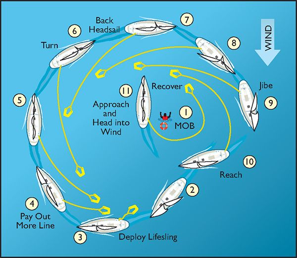
In 2005 a colleague from the USNA Sail Training program and I participated in an on-the-water Crew Overboard Rescue Symposium on San Francisco Bay. It drew from a nation-wide array of professional sail trainers, yacht club sailing program directors, safety equipment manufacturers and retailers, plus recreational sailors from up and down the West Coast. Days on the water spent rescuing volunteer MOB victims were followed up with late afternoon summary sessions (see “Slings, Scoops, and Ladders,” PS January 2006 )
The reoccurring problem seen on the water was a widespread inability to stop or even slow down near the person in the water (PIW). Boats approached with too much speed, often on a sailing angle that made depowering impossible. The net result was a overabundance of “flybys” and the need to set up for another approach.
Veteran Lifeguards solve the problem of bridging the gap with a slogan “reach-throw-row-go.” It defines priorities, and with a slight change this mnemonic tool can help sailors approaching a PIW. The sailor’s version of the slogan becomes reach-throw-tow- (and perhaps go).
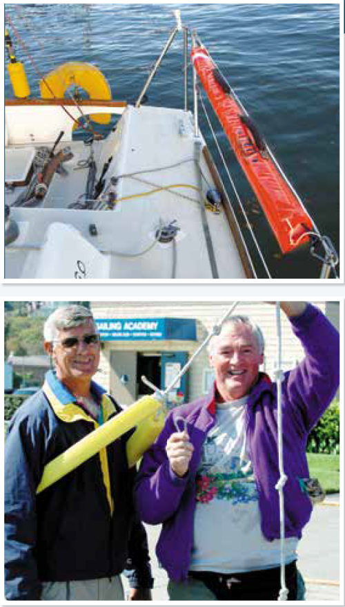
The reach aspect can be a hand grab or a boat hook extended to the PIW. The throw aspect is what Le Cam settled on and put to good use. He grabbed his stern mounted SILZIG buoy and used it as a heaving device. His first toss bridged the gap between Kevin Escoffier’s life raft and his IMOCA 60. Slack line was pulled up and both sailors heaved on the line to bring the raft closer to the stern of Yes We Cam. The raft and stern surged in the seaway and agile Escoffier timed it right making his transition to safety.
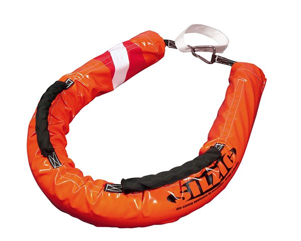
The SILZIG buoy is a towable and throwable rescue buoy that has caught on in Europe the way the Lifesling has captured the interest of U.S. sailors. It seems more home-brew than high tech, but some of the best innovations come from such lineage. At the 2005 San Francisco safety training event mentioned above, a creative crew were showing off a prototype that they branded as the Noodlevator (see photo at left).
Apparently, the development process didn’t go as well as the SILZIG buoy. But it does remind us that a life ring on a line is a very effective, throwable rescue device. A Lifesling is a very good towable device. The question is does the SILZIG buoy offer both attributes? During the summer we will take a close look at towable and throwable MOB candidates and come up with some useful observations.
Suiting-up for Survival.
Over the years we have been testing survival suits and dry suits of various brand and design. They all rely on seals at the wrists and ankles or built-in boots and gloves to help keep the interior dry. The neck seal and entry point zipper are also areas of serious design consideration. We found that earlier designs with thick neoprene rubber skin and attached boots and mittens were very warm but the most immobilizing of all options.
A sailor in the process of abandoning ship has a lot to do, and one of the first requirements is to don the gear that will most effectively prevent hypothermia. A big problem arises when that suit and its attached mittens limit dexterity, preventing things like radio communication, button pushing and releasing snap shackles and other life raft constraining clamps. Our research on immersion “survival” suits found that removable mittens or gloves are a must, and lighter weight, more flexible suits are not as restrictive and allow a sailor to better handle the jobs at hand (see “Immersion Suit Test,” PS July 2007) We also noted that thermal protection had more to do with the layers worn under the skin of the suit rather than the suit itself.
Compared to the survival suits we tested, Escoffier’s T.P.S. Manoeuvring Suit was made of much thinner 3mm neoprene covered by a rip-resistant nylon on both sides. It had removable mittens, a non-zipper means of suit entry and a built in hood that had a high visibility to stripe. The user donned the suit feet first through a large across-the-shoulders opening. Once the suit was on, the dry bag like shoulder slit must be rolled up and clipped to the chest harness, providing a water tight, roll type seal. We have also tested dry suits that share this feature (see “Drysuits and Wetsuits for Sailor,” PS March 2009).
A Glint of Light
In the end, a little bit of light saved the day. When Jean Le Cam noticed the first glint, it turned out to be some low wattage light beamed from Escoffier’s life raft canopy lamp refracting off the wave faces. Detection was not made due to an abundance of Lumens, but due to a skilled mariner’s night vision and the darkness linked to being away from shore side illumination. It was the final link to a rescue after 11 hours of bobbing around in a life raft.
Had Le Cam missed that dim visual cue, there was still time in the EPIRB battery’s life to home in with the ongoing triangulated search. But, if no vessels were in range, as with many long distance cruises, the hours in the raft would likely become days. So a cruiser’s best bet would include having the grab bag in the raft and among its contents a second EPIRB, a hand pump water maker and perhaps each person in the crew should be equipped with a PLB on their life jacket. Using these devices sequentially, turn one on when another has run its battery down, extends the duration of the distress signal. In empty stretches of open ocean it’s a 406MHz signal that reaches out to a wide range of search and rescue assets.
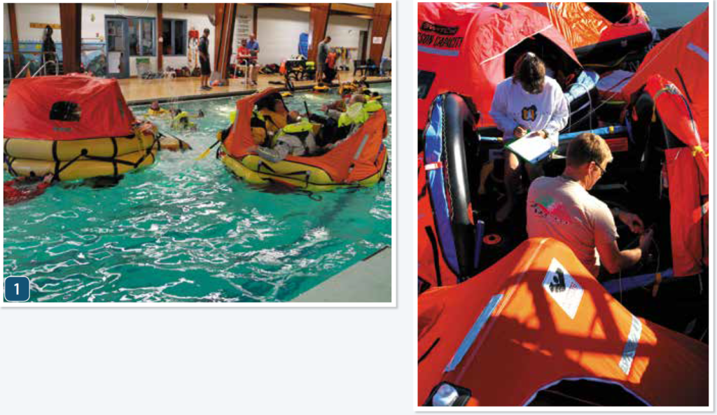
SOLAS rafts, which also have specified equipment stored in the raft.
2. PS testers evaluate life rafts prior to on the water testing for our comprehensive
life raft test, featured in our “Survival at Sea” ebook series
(www.practical-sailor.com/products).
When it’s rough enough to cause a carbon fiber reinforced, 60 foot racing sailboat to disintegrate, what chance does one have in a 130 pound, inflatable life raft? The answer is: a pretty good chance. The reason why is that over the last couple of decades there’s been a steady improvement in life raft design and construction. Higher modulus materials, better seam bonding, more reliable bladder valves and features such as inflatable boarding assists, improved arch and canopy designs and more efficient ballast bags have added up to improved survivability for the raft and its occupants .
The tricky balancing act is the total weight of canister, raft and equipment packed inside. For example, The fabric used in the manufacture of SOLAS life rafts is heavier and higher tensile strength than the material used to make ISO 9650. The SOLAS A-pack equipment load includes water and food and is another major source of weight. When all is packed into a raft canister the 6 person SOLAS raft weight with an A-Pack is 163 pounds.
A six-person ISO 9650 offshore raft, in a canister, weighs as little as 89 pounds. The lighter material and fewer supplies along with a smaller volume CO2 inflation tank contribute to the lighter weight.
Escoffier was able to launch the heavy SOLAS raft that had been cockpit stowed. He had been unable to retrieve his abandon ship bag that was stowed forward and was underwater. Having the in-raft-stowed A-pack with its food and water supplies was beneficial. ISO rafts provide 500ml/person water but no food supplies. The idea is that such needs would be compensated for with the load out in the abandon ship bag.
Conclusion
The message for mainstream cruisers and racers was summed up pretty well by a friend who loves to race offshore but has also had an extensive maritime career. Kip Louttit is a retired USCG Captain who is now the Executive Director of the Maritime Exchange of Southern California. His day job is controlling commercial vessel traffic in one of the most fog-bound and busiest regions in the world. However, when it comes to survival at sea, Kip reverts to USCG days and says—”stay afloat, radiate an electronic distress signal and we’ll come get you.”
Interestingly, the Vendee Globe Race uses a similar tactic, but each competitor knows that, in extremis, they may become the rescuer or the person in need of a rescue.
On January 6, 2009, Jean Le Cam was sailing another IMOCA 60 when the ballast bulb broke free, flipping the boat upside down. Le Cam’s closest landfall was Cape Horn. Fellow competitor Vincent Riou was vectored to Le Cam’s position and asked the skipper if he wanted a lift. Ironically, Riou was sailing the same boat Le Cam would come to rescue years later—PRB. It’s good to see some seafaring traditions are still alive and well.
Ralph Naranjo, PS editor-at-large, is an adjunct lecturer at the Annapolis School of Seamanship and the author of The Art of Seamanship, a comprehensive textbook aimed at the advanced cruising sailor.


