
")
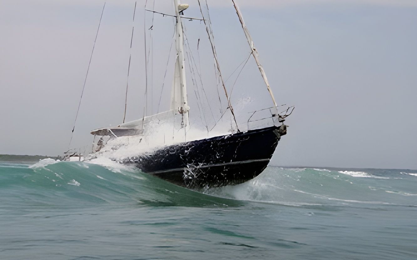
Lightning is an anomaly: It strikes wherever and whenever it wants. In my case, it struck me and by boat 200 miles south of Central America in 2011, on a glorious passage from Peru to Mexico. It was 2000 hrs, dark, and my one crew member, my friend Michael, was asleep in the aft cabin. I was on watch in the cockpit when I noticed a spectacular lightning event on the horizon, and was able to verify on my radar that it was approximately 20 nm away. “Terrific! Mother Nature is giving me a wonderful lightning show to entertain me!” I said to myself. Suddenly, I smelled smoke coming up the companionway.
My custom-built, 48-foot, steel-hull monohull Precious Metal boasted an engine room that was every sailor’s dream. Access was through the walk-in door from the aft cabin, and a trap door on the floor of the main salon. I quickly lifted the salon trap door, and a huge cloud of smoke escaped out of the enclosure. There was a fire in my engine room!
I refrained from introducing more oxygen into the fire by not opening the walk-in door. Once the smoke dissipated and allowed some visibility, I climbed into the engine room via the trap door. Every wire and hose throughout the entire engine room had completely melted and was dripping black sooty goo, which is incredibly toxic when inhaled. There were electrical shorts popping up everywhere. I was horrified, scared and feeling incredibly overwhelmed. It was my worst nightmare.
CHOOSING A DESTINATION FOR REPAIRS AND REST
Thankfully, the winds and seas were cooperating, and we were able to sail. Michael was attentive and watched for traffic, as I assessed the situation. Our intention had been to sail directly to Zihuatanejo, Mexico; however, this new turn of events meant that we needed to immediately alter course to the best, closest and easiest place in Central America where I could do major repairs. Serious consideration was given to a destination that could not only facilitate repairs, but also a place where I would enjoy spending a long time in going forward. I knew that Precious Metal would require brand new wiring throughout the boat, and electronics, plus whatever else that would be uncovered as the effects of the lightning event unfolded. Thankfully, I had insurance.
Ultimately, I redirected Precious Metal towards El Salvador. Long time cruising friends Bill Yeargan and Jean Strain were establishing themselves in Bahia del Sol, El Salvador, as a cruiser’s haven, and I felt they would be instrumental in both assisting with the repairs as well as social and emotional support.
ASSESSING THE DAMAGE AND MAKING A NAVIGATION PLAN
At this stage, every piece of electronic equipment that was linked to wiring was down: radar, auto pilot, navigation equipment, radio, lighting—interior and exterior, and the fridge. Wiring was shorting throughout the boat in so many places that I was forced to cut the wiring into electronics that were actually still working. My handheld VHF and GPS were both functioning; however, I couldn’t use them except in an emergency for fear that they couldn’t be recharged. (The VHF radio could be used to call passing ships for assistance and upon entering the port. The GPS would be used periodically to check our position.) Sparks were even ignited in the electrical outlets throughout the boat. Thankfully, the engine was working, but I chose not to run it until I needed the power to anchor and/or enter the port—just in case I only had minimal time of operation.
I took a bath. Challenges always feel more traumatic in the darkness of the night. My body was covered in horrible black wiring soot. The toxins from the burnt wiring eventually created chicken pox-like welts on my arms, legs and torso. I needed to regroup, compose myself, and dig as deep as I’ve ever needed to survive. Michael was terrific support, which was fortuitous insofar as many people would have panicked in this situation.
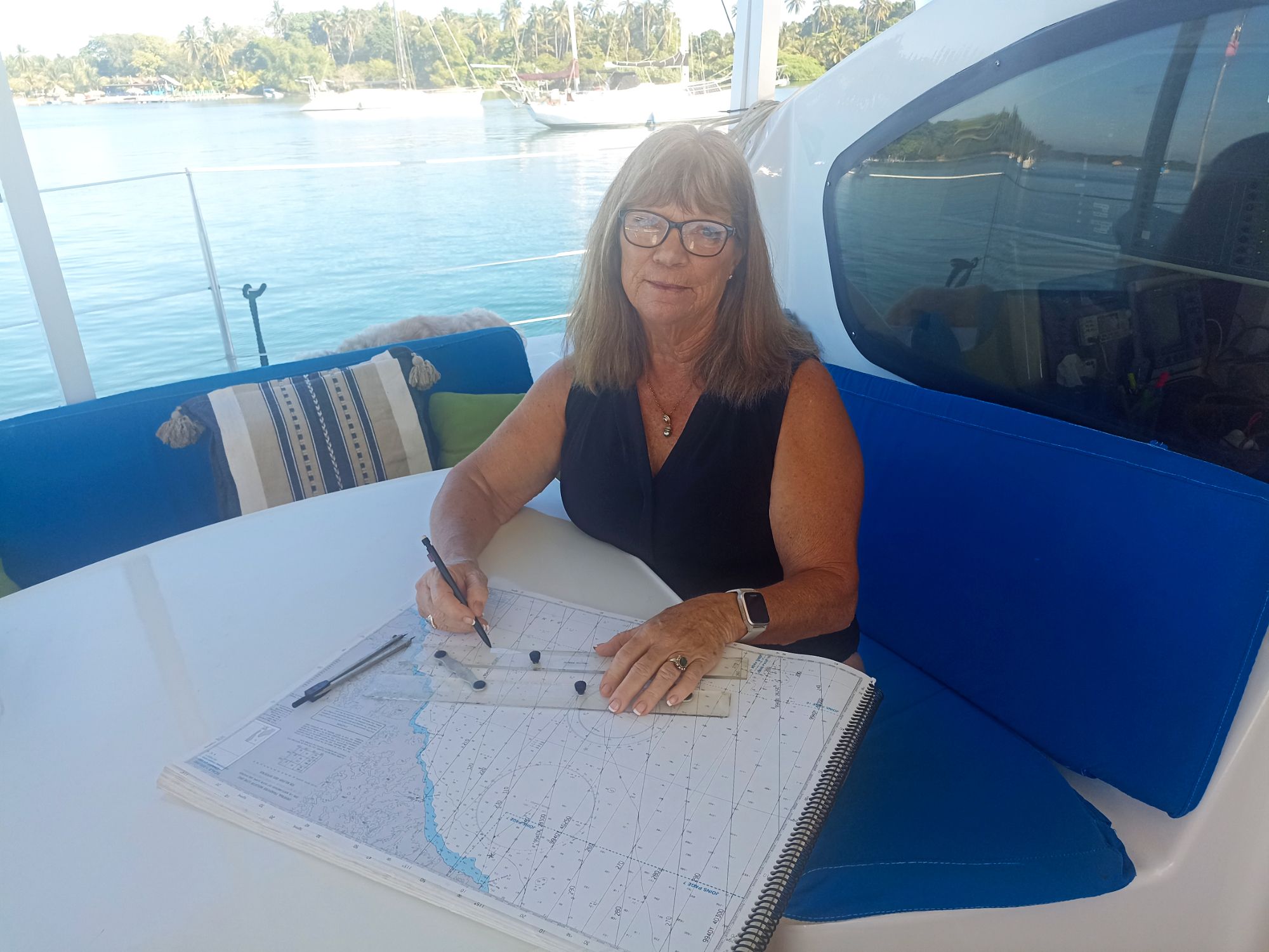
My next task was to establish navigation protocol for the 200 nautical miles to El Salvador—using only a compass and paper charts. Thankfully, I knew our exact position when the lightning stuck because I always tracked my course on my paper charts whenever I’m at sea. I then used my handheld GPS sparingly to update our position on the paper chart, and created a course heading directly towards Bahia del Sol, El Salvador.
NAVIGATING WITHOUT ELECTRONICS
Navigating by compass and charts isn’t rocket science; however, it could be overwhelming for a boater who is in a distressing situation. Thankfully, I turn all my electronics off every third day at sea, so that I can practice managing the boat without the assistance of technology—for this very reason! Therefore, transitioning into the traditional form of navigation was a natural progression for me. I calculated that we had approximately 200 nautical miles to the entrance of Bahia del Sol, at an approximate compass bearing of 330 degrees—I don’t have the exact course direction as it was many years ago—which, at an average speed of 5.5 knots, would bring us to the entrance in approximately 36 hours. I also had all the tools to navigate by using dead reckoning technique: compass, charts, dividers, pencil and a parallel ruler.
Precious Metal arrived safely outside Bahia del Sol mid-afternoon 36 hours later with no further adversities. By this time, all the feeling in my limbs had vanished, and my body was covered in tiny spots from the chemicals in the burnt wiring. I needed immediate medical attention. Thankfully, my engine and windlass for anchoring were functioning. I was greeted wonderfully well by the cruising community once we entered the bay.
As a bonus, Bill and Jean were hosting their annual El Salvador Rally that week, and I knew several people who had sailed their boats from Mexico. Notably, Henry Robinson aboard his catamaran Rapscullion was in the bay and was incredibly attentive and helpful when I first arrived. I now refer to him as my “white knight” because he not only fed me, assisted with the boat repairs and medical appointments, but we also fell in love and have been together ever since! Adversities usually have a silver lining when the smoke has cleared.
ABOUT LIGHTNING
I’ve learned a lot about lightning since that event. According to all lightning experts, including a special research team at the University of Florida, there was nothing I could have done to avoid being struck. Boats often hang creative deflection apparatus on the masthead and over the lifelines below the water, but the insurance and lightning specialists continue to reinforce that lightning will do whatever it wants.
Apparently, the spectacular lightning event that I happily welcomed on that fateful night was not so friendly. Just 20 miles away from the bolt, Precious Metal was the closest grounding for the strike. As the bolt traveled 20 miles across the water it gained speed and intensity. The lightning bolt entered Precious Metal through the engine exhaust pipe and consequently swept throughout the engine room and then discharged out of the keel. I never witnessed anything until I smelled smoke.
I also learned that the bolt was so strong that had my boat been any other material besides steel, it would have been fatal. Wood and aluminum hulls would likely have burned, and a fiberglass hull would have likely blown threw hulls due to the force. It is believed that the steel material acted as a Faraday cage, like our oven, which provides protection for essential or valuable electronic devices to prevent such disruption. Michael and I were extremely fortunate.
It took between six months and a year for the feeling to completely return to my limbs. Experts decided it was a peripheral hit, given that I was in the cockpit when the lightning bolt struck underneath me in the engine room. My immune system was compromised from the strike as well as the toxins, and I required B12 shots every two days for six months. Those shots took me into interesting medical facilities between El Salvador and Panama over the following year. One facility in Honduras charged me $3.00: $1.00 for the serum, .50 cents for the doctor, and .50 cents for the needle.
Some of my electronics, including the autopilot, were not available at the time in El Salvador (they are now); and therefore, Henry and I each solo sailed our two boats over 1000 nm to Panama in October after all the wiring was replaced on Precious Metal. It took and entire year before Precious Metal and I were once again whole.
THE IMPORTANCE OF PAPER CHARTS
This story would probably have had an unhappy ending if I didn’t know how to navigate by traditional compass and paper charts, and also operate my boat without any electronics or power consumption. I commonly witness boaters today who completely rely on electronics. They not only fail to have the ability to navigate traditionally, but they do not even carry the equipment. I held a seminar on Central America last year in Mexico and suggested that everyone bring their charts. There were fifty people in the room and not one person had a chart; rather, everyone had tablets.
Starlink is now a huge game changer for offshore boaters—which is wonderful, until it is not. All this technology takes power. Alternators, solar and all sources of power can break down. This wonderful technology equipment can be a false sense of security. When I first crossed the Pacific with my former husband two young children in 1986, we navigated from Victoria, Canada to New Zealand and then to Japan strictly using a sextant and mathematical reduction tables (no GPS then). Our only communication was SSB and ham radio.
Becoming proficient at traditional navigation is not only a useful skill, but it is fun and wonderfully satisfying. It is easy to learn both traditional compass and chart navigation through online courses and YouTube demonstrations. While charts are no longer as easy to access in traditional marine stores, they can be downloaded and printed through sources such as OPEN CPN or other chart providers depending on where you are planning to navigate.
A full “how to” explanation of dead reckoning, originally called “deduced reckoning,” requires more time than this article allows, as well as a progression of practical skills that will only develop through practice. That said, here are some basic concepts: 1. Establish your known location and mark the exact time of this position. This is referred to as a FIX. Draw a line from your known fix to your destination using a pencil and ruler. 2. Using the latitude lines on your chart and dividers, you can calculate the destination distance based on the fact that every latitude line represents 60 miles. Do not use longitude lines as a distance reference. Increments on the side of the chart break down the latitude distances into smaller amounts. 3. Place your parallel ruler on the closest compass rose to the DR line on your chart and guide the ruler from the exact angle in the compass rose to your DR line. This will give you your course. True is indicated in the outside circle and is commonly used for DR. On the top of your DR line, write the course: e.g. C 90 T. 4. Estimate your speed, and on the bottom of the DR line, insert the speed: e.g. S 6.0 kn. Now you have your distance, course and speed. In order to calculate your distance made good over the water, the simple formula is: distance= speed x time traveled / 60. You must plot your updated position on the DR line every hour, and at any time that you alter course. A crew change also requires that the chart position to be updated, as well as the time. The above DR protocol becomes more complicated due to wind and current—especially for sailors who don’t follow a straight line. This is referred to as set and drift. Set refers to the direction that the current and/or wind is flowing, and drift relates to the speed of the flow. Determining set and drift accurately takes wisdom, observation and experience at sea. Variables include wind speed, current strength, wave height, tide strength and changes. The above is just a small taste of dead reckoning protocol to provide an understanding of its complexity and the importance of learning and practicing these seamanship skills. 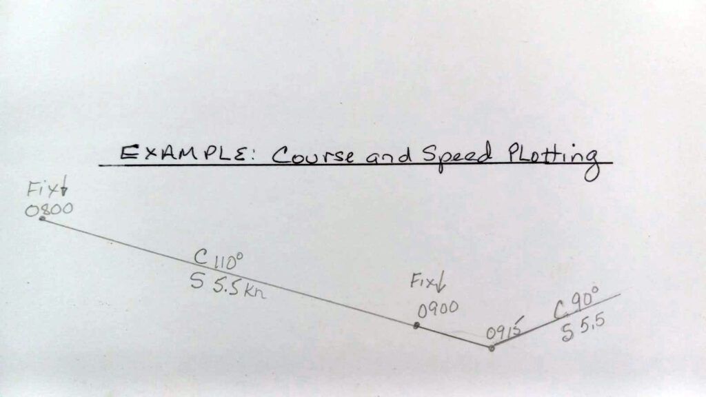
CONCLUSION
They say that offshore sailors become nervous when they see land, and inshore sailors become nervous when they do not see land. Regardless, we always need to know our location. Turning electronic navigation equipment off every three days while sailing (or on a regular basis) will ensure that you readily have the proper navigation equipment and also know how to use it.
The Bowditch American Practical Navigator has extensive information relating to all types of navigation including dead reckoning and celestial. I strongly encourage all boaters to step aside from modern electronics periodically, and I am confident that it will open an exciting and safe new world.
Happy sailing and be safe.


Great article driving home the need to have an active paper chart and an ongoing plot in fair and foul seas.
Great article. While I do not do off shore, the same principles hold true for lake sailing. I will start practicing using my paper charts more Thank you
I had a GPS failure off the east coast about 25 years ago, when back-up GPS was rare. However, like Pamela, I had recorded our position every 4 hours. I learned coastal piloting as a part of learning to sail and hike years before, and dead reckoning is just high school physics. I still had paper charts. For two days I plotted our course on paper, guessing about the Gulf Stream and correcting for what I knew of our probably leeway. I intentionally plotted course about 5 miles north of our intended landfall so that I would know which way to turn when I sighted land. Binoculars help.
Thankfully the weather remained fair. Everything went according to plan and it was a plesant expereince. The keys were having recorded our position on a regular basis, having adjusted the compass a few years before, and having paper backups. I still have paper charts. They are far out of date but will serve to get me home. For the most part, the only things that change are buoy positions and highly mobile shoals, but as long as you expect that, careful observation should get you through. Regarding entrances with highly mobile shoals, there is nothing wrong with getting on the radio when you get close and asking for local knowledge. If the radio is out, hail a local boat.
Thunderstorms with lightning are not uncommon during the summer months on Lake Erie, where I do most of my sailing these days. I have also sailed on the east coast of the US in the Atlantic, the Caribbean, the Gulf of Mexico, and a few other areas. Luckily, I have only been caught in lightning storms about six times. I keep paper charts, parallel ruler, and dividers on my boat.
Another thing I keep on board is a pair of automotive jumper cables. If we are approaching a thunderstorm, we clamp a jumper cable to the base of our upper shrouds and toss the other end into the water. We do this port and starboard. My thinking is that this provides another path for the lighting to travel. I do not know if it works, but I have never been hit by lightning.