

In theDecember 2009 Practical Sailor, we covered navigation programs for a collection of PDAs, smartphones, and Windows Mobile-based pocket PCs. In January, we reported on options for supplying GPS data to smartphones and PDAs that lack onboard GPS receivers. In the first article, we asked Apple lovers to standby for a dedicated article on the iPhone, and we still got a lot of urgent reader letters.
Photos by Doug Logan
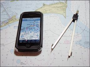
So-without further ado-heres a brief wrap-up of the navigation programs we tested for Apples now-legendary game-changer, the iPhone, which still operates exclusively through a cellular contract with AT&T. (These programs are changing daily, so by the time you see this article, it will be out of date. We hate that part of paper publishing.)
Hardware Features
By now, there are relatively few first-generation iPhones in use, so well focus on what can be done with the second-gen phone, the 3G, and the latest generation, the 3Gs. Both carry basic GPS receivers, which are augmented in their triangulation processes by signals from cellular networks and Wi-Fi hotspots. This is called Assisted GPS, or A-GPS, the main advantages of which are the ability to triangulate quickly and accurately with a variety of available signals and to help conserve computing resources and battery power.
Theres little available but scuttlebutt about the exact native capabilities of the iPhones GPS receiver. The consensus in the technical community online is that it uses the off-the-shelf Hammerhead II GPS chip made by Broadcom, a subsidiary of the German company, Infineon. The chip, smaller than 14 square millimeters, is said by Infineon to deliver “sensitivity to -160 dBm and position fix times as fast as 1 second, exceeding 3GPP specifications.”
Despite calls and e-mail exchanges, neither Apple Computer nor Infineon was willing to provide any specifics about the number of channels on board. We would hazard a guess that it is a single-channel, fast-sequencing receiver, and would welcome a correction or amplification from the manufacturer.
Navigation Apps
Aside from its slick design and cult-following, what sets the iPhone apart from other smartphones and PDAs is the benefit that both Apple and their iPhone users have reaped from Apples encouragement and support of third-party applications, or apps. Now numbering about 100,000 and available for download via iTunes (www.apple.com/itunes/) or directly into the iPhone with an iTunes account, these apps run the gamut from sublime to ridiculous, and from frilly to astoundingly clever and useful. As software programs, they are very inexpensive, ranging from free to about $50.
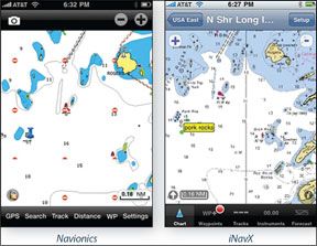
With A-GPS navigation capabilities, the iPhone is a natural conduit between marine cartographers and users, and there are several nav apps already available. Well concentrate on two companies that have established the biggest presence, Navionics and iNavX, and one we mentioned in the December issue, Memory-Map. Since its impossible to list all the features of each app, well focus mainly on the cartography and user interface.
Vector or Raster?
Practical Sailor
Any kind of cartography is best downloaded by a full Internet connection, either via iTunes download or by Wi-Fi directly to the phone. The second choice is by cellular data connection, and this is the only way sailors will be able to gather charts on the water. We found cellular download times for both vector and raster charts to be reasonably short.
However, sailors out of cell range will need to have all necessary charts already loaded on their phones. In this case, vector has it over raster, for the simple reason that full coverage of a large area will take up much less memory. For example, the Navionics app and the entire U.S. East region take up only 291 MB. The iPhone 3G currently sells with 8 GB of memory; the 3Gs has either 16 or 32 GB.
With any decent online connection, that advantage is somewhat neutralized, because raster charts can be loaded and discarded very easily as necessary, depending on the iPhones available memory and the sailors immediate needs.
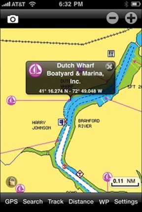
Vector charts are seamlessly quilted together so that you can drag, zoom, and pan big distances without having to close one chart and open another. The downside of using vector maps in a handheld is that you often can’t see details at one level that are available at another, and the density and choice of detail often seem arbitrary. Another caution is that labels that appear correctly at one resolution often move out of place at another. However, vector programming allows for point-of-interest (POI) information, which can be tied directly to each chart. Navionics, for example, includes marinas, marine repair shops and stores, boat dealers and builders, waterfront restaurants, tides, and currents.
How We Tested
Getting far enough off the New England coast in mid-winter to be out of range of all cellular signals was not an option during testing-especially with the test boat on the hard under a foot of snow. So we headed to an area of Vermont where we had either “no service” or a flat base of reception bars. From a cold start, it took the iPhone a full five minutes to self-locate with GPS only. After that, the lock was fair to middling. The next day, testers got a lock in two minutes.
We toggled through all the GPS-reliant apps on the phone and found that not all behaved the same way. The Navionics app was the first to show an accurate position, even though it was on a chart with only rudimentary information that far inland. It was followed by GPS Motion-X, a land-oriented app that has many functions but no integral cartography, then by iNavX, which gave an accurate lat/long fix but nothing on a chart, then Google Maps, which froze for several minutes without a fix within about a 15-mile radius. Google Earth refused to load at all.
Closer to home and with strong 3G cellular signals, we cold-booted and ran two iPhone 3Gs side by side, one with the SIM card removed. The phones both located themselves in about 5 seconds with the same radius of accuracy. The difference was that when we took them on a car ride, using Google Maps as the cartography, the phone without the SIM card quickly lost track of itself on the map but did update lat/long.
So, without assisting signals from cell or Wi-Fi networks, the iPhone will self-locate, but there will be no cartography-what you bring with you is what youll have. Also, the standalone GPS function is far from robust compared to what boaters are used to. With GPS only, and at the slow speed of sailboat travel, the SOG/velocity readout will tend to be quite sketchy. Alongshore, the iPhone will provide adequate real-time information. Offshore, it would not be the backup of choice. A dedicated handheld GPS with cartography would be much better.
Even so, when in range of all available signals, the iPhone and its marine navigation apps are a great way to investigate, plan routes, set and send waypoints, and generally have fun at a very low cost for cartography.
Interface and Onboard Software
The touchscreen user-interface and functions of the iPhone are becoming familiar even to people who don’t have an Apple product: Drag maps and charts and tap to select; pinch to pan, and spread two fingers apart to zoom. That covers all the basic operations. The iPhones estimated radius of accuracy is shown as a pulsing light blue circle around the estimated position. The smaller the diameter of the circle, the better the fix.
The iPhone comes equipped with Google Maps. The user can choose between street maps, a satellite view, or a hybrid view. A host of land-oriented apps coat-tail on the basic A-GPS and Google Maps setup, but much of this cartography is served to the phone as-needed via Wi-Fi or cell signals-its not always resident on the phone.
Navionics
Navionics won an innovation award for their app in 2009 from the National Marine Manufacturers Association. The app runs vector charts-derived from Navionics Gold XL9 Charts and from HotMaps Premium-of pretty much the whole navigable world: 28 downloadable regions covering the U.S., Canada, the Caribbean, Central America, Europe and Scandinavia, Africa, the Mediterranean, the Indian Ocean, China, and more. Most regions cost $10 to $12, but some are more expensive. The Caribbean and Central America is $20, while those covering Skagerrak and Kattegat run $50.
In our evaluations, zooming, panning, and dragging Navionics vector charts was no faster and in some cases slower, than the same actions on raster charts, but Navionics had the edge in large-area movements because of the automatic quilting.
Basic operations on the app are intuitive, with six text buttons at the bottom of the main chart screen for setting up tracks and waypoints, determining range and bearing between locations (by placing and dragging pin icons), searching, and program settings. The search function works for points, tracks, and routes that the user has set, as well as POIs by category and name, and lat/long coordinates by the rolling “one-armed bandit” wheels familiar to iPhone users.
Navionics has no dedicated “Instruments” screen as there are in the iNavX or Memory-Map programs. Speed and range/bearing to waypoints are indicated only when the vessel is moving. We think such a screen, giving at least COG/SOG, range/bearing, accuracy radius, and constant lat/long coordinates, would be a good addition.
Navionics provides a very good help file with instructions right in the interface. Theres no need to visit the website or consult a separate file.
Bottom line: Easy to use and with excellent features, Navionics is the PS Best Choice for an iPhone nav app.
iNavX
The iNavX marine navigation app was among the first sailing-related apps to appear for the iPhone and still sells for its original $50 price. It uses NOAA/RNC raster charts, which are free and can be downloaded at one touch, while a robust set of charts in several other formats-including Navionics Gold and Canadian hydrographic digital charts-can be bought and downloaded via Fugawis X-Traverse online map store and server. X-Traverse “lets you save, retrieve, and move data across iPhone or other mobile or desktop applications.” (A $10 annual subscription is required for 100 MB waypoint storage and 1 GB data transfer; a free trial subscription is available.)
iNavX also supports routes and waypoints for Google Earth, GRIB weather forecasts, NMEA data via TCP/IP and Wi-Fi transfer, and even AIS transponder data by the same method. Most of these peripheral functions need to be downloaded in separate modules from other sources. While iNavX will run some vector formats like Navionics Gold and MacENC, it does not work with NOAA-ENC, nor with the Navionics Mobile vector charts sold in the iTunes app store specifically for the Navionics iPhone app. To be clear, it does run Navionics Mobile vector charts, but they have to be bought from X-Traverse to work on the iNavX app. Prices are the same either way; most commonly used chart areas cost between $15 and $25.
iNavX uses the iPhones current location to serve lists of charts available in the area, and the charts can simply be downloaded and discarded as necessary. This preserves valuable memory in the phone, a valuable feature, especially for the 8-GB version.
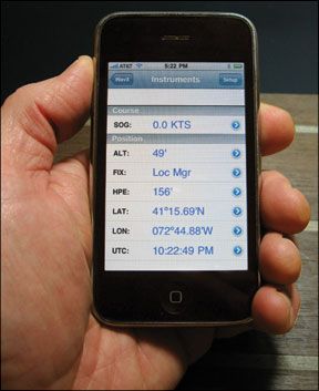
The user-interface isn’t flashy, but its intuitive. The opening page lists the macro areas-USA East, USA West, Gulf of Mexico, Great Lakes, Alaska-as well as links to an instruments page, anchor alarm, e-mail position link, and program setup.
Tap your chart choice, and youre taken to NOAAs formal chart list for the area, including chart numbers. Once your chart is loaded, you can tap the screen to set a waypoint, and touch the waypoint marker again to select and drag it. The /- buttons on the screen will zoom or pan or take the user to a list of other charts covering the area. Icons at the bottom of the screen take you to management pages for waypoints and tracks, an instrument page showing a strong set of GPS-related data, or a page to access tide and weather/GRIB information (once youve set up access separately through X-Traverse). A small “i” icon reveals information about the current chart, and a Setup button leads to program settings.
Bottom line:iNavX is a powerful program that can run a variety of charts and do an impressive number of jobs with added modules and a bit of commitment from the user.
Memory-Map
Our December article covered the Memory-Map Pocket Navigator for Windows Mobile. We were able to have a look at the beta version of the companys iPhone app for this article. The finished app, with minor bugs fixed, is now available in two versions in the iTunes app store, a free version that runs small-scale charts only and a full version for $33 that runs more detailed charts.
Memory-Map in some ways has a similar look and feel to the iNavX program, but it is simpler, somewhat more streamlined, and less full of bell-and-whistle options and third-party connections. Memory-Map runs NOAA/RNC raster charts formatted to work with their program, along with raster charts from other sources covering Canada, the Caribbean, and other areas. It does not run vector charts. The NOAA charts are free to download with the $33 version of the program; a touch of Memory-Maps Digital Map Shop button, and the user is taken to the full list of charts. Touch a chart, and it loads into the phones memory. Users can also download a program to their home computer to manage cartography.
The interface is very simple, with two pages: a chart view and an instrument read-out view, with context-sensitive icons to tap in each case. The chart page has icons for charts (both stored in the phone and available for download), search, GPS lock, and waypoint setting. The instrument page has icons for waypoint information and track lists, program settings, and help.
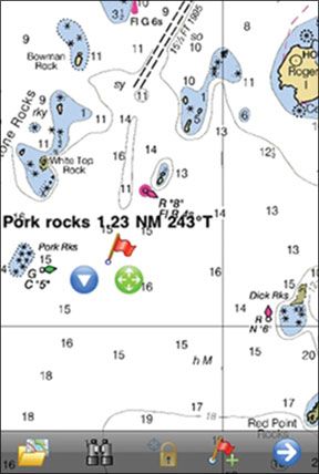
The onscreen device for waypoint management is one of the cleverest bits of thinking and programming weve seen for handheld instruments. To set a waypoint, the user taps the flag icon at the bottom of the screen, and a three-element waypoint controller appears: a flag whose staff can be planted with accuracy, a four-way directional button that is used to drag the flag without obscuring it with a fingertip, and a menu arrow that lets the user edit the waypoint information or delete it right from the chart screen.
Bottom line:For those who prefer raster charts, and given the limitations of doing serious navigation on an iPhone, we would give the nod to Memory-Map over iNavX because of its relative simplicity. In some cases, basic features that are easily accessed are preferable.
Conclusion
If you have an iPhone already, the price of all three apps together is negligible compared to what most of us are used to spending on electronic navigation gizmos. Of course, with the iPhones limitations as a GPS receiver, the apps are all best used for planning and “nav lite.” Using nav apps is not recommended as a standalone approach to navigation.
If youre headed offshore and need a backup for your handheld backup, or your iPhone memory is already stuffed nearly full, go with Navionics Mobile alone. If you have room, add the Memory-Map app. That would make a good combination of vector and raster.
For the more technically inclined and for data addicts, the iNavX is a very seductive program. Its $50 cost is the steepest of the three, and an X-Traverse subscription will add more.
For a roundup of other sailor-suited iPhone apps, check out the online version of this article at our website, www.practical-sailor.com.
readers are generally well-versed in the differences between raster and vector cartography, and the pros and cons of each, but heres a super brief rundown: Raster Navigational Charts (RNCs) are digital images, snapshots of a chart. With vector, or Electronic Navigational Charts (ENCs), each of the charts features is digitized, providing real-time information and allowing users to select displayed features that enhance navigation. (Visit www.nauticalcharts.noaa.gov/mcd/learn_diffRNC_ENC.html for more information and a concise explanation by NOAA.)


