

Marine electronics companies have joined forces with the two nationally known satellite radio providers, Sirius and XM, to provide weather information and weather maps to the mariner for moderate monthly fees. In this test, Practical Sailor takes a hard look at who provides the best satellite weather service, including weather radar, geared toward cruising sailors at the best overall price. We reviewed the XM marine weather forecast using a Garmin GDL 30A weather receiver linked to a 10.5-inch Garmin 3210 multifunction display. The Sirius system was tested with a Raymarine SR100 weather receiver providing the signal to Raymarines E120 multi-function, 12-inch display.
***
Relevant and timely weather data has become easier to access than ever before. For decades, U.S. Coast Guard HF voice and weatherfax broadcasts have been the staple source of weather information for offshore navigators, as discussed in Nick Nicholsons Offshore Log published in the Jan 1, 2000, issue (and now on www.practical-sailor.comunder”). If budget-friendly weather forecasts are your priority, then this is still your best option. (See “Rhumb Lines,”)
During the last decade or so, a variety of software has allowed users to download weather data, typically in GRIB format, that can then be used to generate a variety of useful weather products, including real-time weather charts, synoptic chart overlays, weather forecasts, weather-routing charts, etc. We evaluated this capability in our recent navigation software test and will be revisiting it in an “Ocean Tested” article on cruising software and another on free (or nearly free) navigation software.
The latest trend in weather delivery is satellite-driven. The weather products evaluated here are designed to integrate with existing multi-function displays (chartplotters). Provided these satellite weather companies can find a way to earn a profit, it is likely that all future high-end MFDs will offer this as an option. The two satellite weather companies profiled in this article, along with others, also partner with software makers so that the satellite weather products can be used with a laptop computer. Satellite communication companies like Globalstar also offers ways to download weather data via satellite.
Future articles on software and communication will address these subjects.
What We Tested
We reviewed the XM marine weather data using a Garmin GDL 30A weather receiver linked to a top-of-the-line 10.5-inch Garmin 3210 multi-function display. The Sirius system was tested with a Raymarine SR100 receiver providing the signal to Raymarines highly rated E120 multi-function, 12-inch display.
XM cannot be used with Raymarine, and Sirius cannot be used with Garmin. There are technical differences between the two satellite signals so only one can be processed by its designated receiver. Because of this, hardware suppliers pair with one particular satellite provider.
Sirius
Sirius Satellite Radio is today one of two nationwide satellite radio service providers transmitting radio and data information to more than 6 million customers. Well known for its entertainment radio, Sirius is also a provider of satellite weather data broadcasts for both aviation and marine users. WSI, a private weather services company, uses data from government, commercial, and proprietary sources, to create timely, accurate weather information, which it provides to Sirius as a bundle of weather products. Sirius then broadcasts this data to customers over a satellite network. Features and data depend on the type of subscription. (See the chart for details.) Our review of Sirius used the Professional subscription.
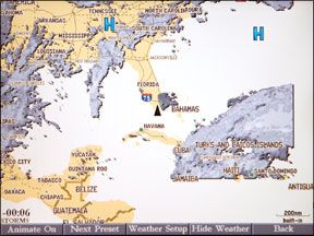
Weather information on the Raymarine unit is displayed on a generic map, not the navigation map page. This means you need to move off the navigation page to access any weather data. We found this to be a significant drawback when compared to the XM/Garmin system that displays weather on the active navigation map.
“We don’t view this as a drawback since the user can create a custom navigation page that contains both the Sirius weather map and the navigation map simultaneously in [separate] Windows,” said Raymarine spokesman Jim Hands. He also said that the multiple window feature allows users to open two weather applications at the same time.
We used a weather menu to turn on all the graphically displayed weather products. They included radar, lightning, fronts, sea surface temperatures, wind speed/direction, and storm-cell tracks. Text weather is brought on screen by moving the cursor over an area, buoy, or storm to display additional textual information about the highlighted feature. Other text reports like marine forecasts, marine warnings, and tropical statements are selected via soft key.
We activated our weather subscription by calling Sirius; a few minutes later, our receiver was online. Data transmission and chart update speeds were fast. Within several minutes of turning on the unit, current weather data could be displayed. Usually, it would take a few minutes longer for all the text info to be available. Sirius and Raymarine claim acceptable signal strength is available all over the United States as well as up to several hundred miles offshore.
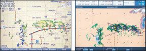
We noted the Sirius system provided an accurate color display of radar and lightning data, including arrows showing the direction and speed of individual thunderstorm cells. By moving the cursor over a storm, more data&emdash;including radar tops, precipitation type, and rainfall rate&emdash;are provided. The cursor can also be moved over displayed marine areas to get localized marine zone forecasts and any warnings that might apply.
After several more hours of using the Sirius weather system on the Raymarine E120 display, we began to notice areas where information was lacking when compared to the XM/Garmin combination. First, we noticed that only a few buoy reports were available, and some of them contained erroneous information. According to Hands, the buoy data comes from NOAA, and some buoys do not have the ability to record and transmit all weather data, like wave height and sea-surface temperatures. “We have discovered that the E120 may display an erroneous wave height or sea temperature in the dialog box,” said Hands. “This condition will be remedied in the software release for the E series.”
When the wave height is turned on, it covers the sea surface temperature data. The wave height and sea-surface temperature can be obtained by placing the cursor over the area and clicking OK. We think this is cumbersome compared to the XM/Garmin graphical display, which includes numerical data and color scaling.
A Sirius subscription can be purchased in one of three types, Mariner, Voyager, or Professional. The monthly cost is $30, $60, and $100, respectively. According to the Sirius website, all three carry the same features. Only the length of the forecast period is different. The Mariner program gives only current weather or a three-hour forecast. Voyager provides forecasts out to 24 hours, while Professional transmits 96-hour forecasts. In our opinion, the cost of the extended forecast period will not be worth the money for the majority of coastal boaters. Wed pick the inexpensive Mariner package.
Bottom Line:
Erroneous buoy data and complicated access to certain weather functions hold back the Sirius service. We also prefer weather data that can be displayed on the plotters navigation page.
XM
XM transmits weather data to the Garmin or any other compatible system through satellite-based radio transmissions. Weather information is collected from both government and private weather providers then analyzed and processed by WxWorx, a private weather company that has partnered with XM radio. The products that are received vary depending on your selected subscription. (See chart for details.) We reviewed XM weather using the Master Mariner subscription.
Weather data is sent to update your receiver from every few minutes to every 20 minutes depending on the product. The most frequently updated item is severe storm tracks. Arrow-like indicators provide speed and direction information on strong thunderstorms in a very timely fashion, with updates every 90 seconds. Other things that can change rapidly, like radar and lightning data, update every five minutes. A longer update time of 12 minutes is the standard for most other items. The longest times are for the satellite mosaic&emdash;every 15 minutes&emdash;and for marine weather forecasts&emdash;every 20 minutes.
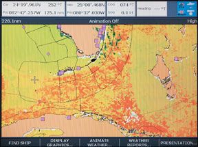
Graphically displayed weather products like radar are viewed on the Garmin through soft key page presets on the map page. Presets called General, Sea State, and Storms can be customized to fit your specific needs. To reduce clutter on page-specific displayed items&emdash;like radar or lightning&emdash;data can be turned off. Or only certain map ranges can be chosen.
Text-based weather information is accessed through the weather tab on the main menu. Here, youll find several more tabs including Current, Forecast, Sea Surface, Marine Bulletins, and Forecast Maps. Each tab has a list of weather information available. For example, the Marine Bulletins page shows the user a list of nearby marine forecasts, which can be selected and read on screen.
Once our weather receiver was activated, we found the data transmission and chart update speed to be fairly fast. Within a couple of minutes after turning on the unit most of the weather data would be displayed, though some like the satellite mosaic might take as long as 15 minutes to display. Both XM and Garmin say the weather system will receive signals and work throughout the U.S. and up to several hundred miles offshore.
We spent several hours using the XM weather system and found all the information useful and easy to access and decipher. Although both XM and Sirius provide similar weather products, we found the XM system carried a slew of items that had more or better coverage or access. Only the XM system provides a satellite mosaic showing cloud-cover areas. Buoy data coverage is more extensive. We found more marine forecasts, and the data was easier to access and read. The sea-surface temperature and wave-height data was displayed numerically on the map page
An XM subscription is available in three classes, Fisherman, Sailor, and Master Mariner. The Fisherman or Sailor package costs $30 per month. Unfortunately, these packages are missing what we consider to be necessary information. Wed have to opt for the more expensive Master Mariner package at $50 per month. Only the latter features lightning data, the satellite mosaic, severe weather tracking, hurricane tracking, wind speed/direction, and wave information.
Bottom Line:
XM provides the best weather information available with its Master Mariner package.
Conclusions
When we began this review and first compared the monthly subscription costs and the data provided by each company, it seemed that Sirius would win hands down. The inexpensive Mariner subscription package contains all the weather products even the most discriminating boater might want at a cost of just over half of the comparable XM Master Mariner service. Issues arose, however, as we got into the nitty-gritty details. The quality and ease of use of XMs weather data is much better, in our opinion. Sirius has less buoy data, no numerical scale for wave height, and no numerical values assigned to sea surface temperature colors. Another big issue was the inability of the Raymarine unit to display weather information on the navigation map page. This meant that you could not easily plan a route around a line of thunderstorms that might have popped up in your area.
This last issue may be solved with the soon-to-be-released Furuno NavNet 2 Sirius weather system. According to Furuno, its system will be able to display Sirius weather data as an overlay on the navigation map page. This will be a major improvement in the user interface of the Sirius weather package.
As things stand now, and even though it costs more money, we think the XM Master Mariner subscription package is the way to go. It provides the best information and the best interface available. Wed also recommend the XM Sailor as a Best Buy, as long as you can live without the lightning and satellite mosaic weather features.
But regardless of the boon satellite weather data has been for the mariner, there will never be a substitute to a properly calibrated barometer and a steady eye on wind direction.


