

Since we last looked at iPad navigation apps (PS, February 2012), there have-not surprisingly-been a number of new developments. Here are a few that appeared on our radar recently.
Garmin BlueChart Mobile
One of the most interesting developments was Garmins introduction of the Garmin BlueChart Mobile nav app, which is proving to be an important addition to the field.
The app is usable only on iPads, iPhones, and iPods that can run on Apples latest operation system for mobile platforms: iOS 6. In fact, if you try to download the app on an iPad 1, youll get an error message saying that you must have an iPad with Apple operating system 6.0 or later.
According to Garmin Media Relations Specialist Wes Owen, iOS 6, in this case, doesn’t allow for backward compatibility. Basically, this all goes back to the hardware on the original iPad and the optimizations that had to be made within the software, in order to work with the new hardware on the more current generations of iPad, Owen explained.
The iOS 6 is available on the iPad 4 with retina display as well as the updated iPad 2, iPad 3, and iPad Mini, and iPod 4 and 5. BlueChart was optimized for iPhone 5, but it can run on updated iPhone 3GS, 4, 4S, and 5.
While theres not yet a BlueChart Mobile for Android smart phones and tablets, Owen said that as the operating system continues to grow in popularity, its something Garmin is considering.
Garmin advertises the app as a planning tool and recommends that users connect it to a Garmin chartplotter and network. In tests, it worked fine as a stand-alone, serving as a backup chartplotter, provided it was used with a 4G iPad with built-in GPS. On board, the Garmin app can connect and sync via WiFi with Garmin (only) chartplotters and networks, streaming GPS data back to the iPad.
Testers tried the Garmin app on a cruise down the Gulf Coast of Florida, first comparing it with the iNavX, Transas iSailor, and Navionics apps (PS, February and March 2012), and then we used it by itself as our principal chartplotter. We were impressed.
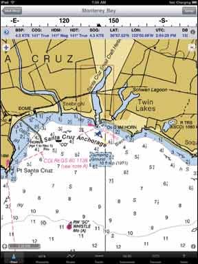
The app has most of the functions of a dedicated chartplotter and is particularly good at creating routes and waypoints. The most noticeable difference from other apps is the Garmin charts, high-quality, proprietary developments of U.S. vector charts. Garmin says that the mobile charts are essentially the same as its BlueChart G2 and G2 Vision charts, but without the fishing information. Testers found the Garmin vector charts to be significantly better than the iSailor and Navionics apps, mainly because the data (water color, depths, nav aids, land features, etc.) are clearer and more legible than with the other apps.
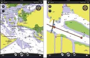
Testers particularly liked the Garmin chart-page user interface. When you tap on the screen, a round wheel that Garmin calls the Radial Menu, pops up, with symbols for nearby features such as bridges, marinas, caution areas, and so on. When you tap on the feature symbol, a pop-up box will appear with easy-to-read, detailed information.
Some of the available information is gleaned from Active Captain, and in our opinion, the Garmin app makes better use of Active Captain data than other apps that use the sailor-generated material, like iSail or Navimatics Charts & Tides (PS, March 2012). One nice feature of the Garmin app is that you can easily turn off or on what Active Captain info displays on the chart; for example, you can have the app display only anchorages, or only marinas, or only caution areas, or any combination. This is a big improvement over the other apps, which always display all the Active Captain info, often cluttering up the charts to the point that you can’t see navigation data. (To use Active Captain, you have to subscribe to it, but its free-and their email updates are relatively brief and inoffensive.)
The Garmin user screen is clean and neat. Across the top are buttons for settings, north-or-course-up, track recording, and searching. On the top left of the screen are zoom buttons (you can also, of course, use the iPad pinching method), and the top right displays a compass circle with the course heading. Across the screen bottom are buttons for centering your boat on the chart, measuring distance, retrieving user info (waypoints/routes/tracks), tides and current displays, and chart content display. (You can choose to display your own route and waypoint info, Active Captain info, as well as weather stations, GRIB forecasts, or Garmins premium weather.) There are also small boxes to display boat speed on the left and heading on the right. Of all the nav apps, only iNavX can compare with the usability of the Garmin screen, in our opinion. Also, testers noted that the Garmin apps user manual is better than other apps weve tested, except iNavX.
The Garmin app has a few shortcomings or things we would like to see tweaked. For example, we think the route line is much too fat on the screen, and theres no adjustment. Theres no look ahead setting, in which your boat icon is not centered but further down your course, so you can see more of where youre going. We like the boat-vector arrow of other apps-a display of a line showing where your boat will be in 5, 10, or x minutes from now.
The Garmin app is a free download from the iTunes app store; however, the app is not usable without the Garmin charts. You can buy a coastal chart package for $30 or a North America package for $45. We found the North America package excellent and would recommend it, although we have heard negative comments about its inland lakes, which we were not able to test in Florida. Were not sure why the mobile package is so much cheaper than the seemingly identical packages for their full-size chartplotters. They also have a variety of foreign chart packages, ranging in price from $42 to $70. They also sell a premium weather add-on for $4. We found the weather tool to be relatively useless, displaying various blobs for cloud cover and radar, but we did not have any extreme weather during our cruise.
Other App Updates Of the other apps we originally reviewed, iNavX, iSailor, and Navionics have regularly offered free updates. iNavX is the oldest and most developed of the iPad apps, and it continues to be outstanding. At $50, its the most expensive, but it can be used with the free NOAA raster charts, so the price is roughly comparable to the Garmin app.
Navionics was originally our second recommendation behind iNavX, but its recent updates have really not kept up with the competition, particularly with regard to route and waypoint handling. Our subjective judgment of their proprietary development of the NOAA vector-chart data is that it is not as good as Garmin, and the Garmin user interface is much better.
iSailor is sold by Russian company Transas, and its two most recent updates show significant improvement, particularly with regard to route handling and user interface. We think their development of the vector-chart data is not as good as Garmins, but their foreign-charts may be better.
The other cheaper nav apps we originally reviewed in 2012 have had no significant upgrades.
Bottom Line
To choose a navigation app (or even software), your first decision should be which type of charts you prefer. If you like the NOAA raster charts-which look like traditional paper charts-then youll want iNavX, which also has fully developed chartplotter functions, as well as WiFi integration with other on-board equipment.
If you like the vector charts-which layer additional information on basic NOAA navigation data-your choices are Garmin, Navionics, or iSailor. We originally tapped Navionics as a top pick, but testers found the Garmin app to be better. Navionics, with U.S. charts, is $10 cheaper than the Garmin, but wed spend the extra money. Of course, if you have an iPad 1 or 2, youll still want the Navionics app-you can use the Garmin app only with more recent iPads.
The iSailor app is by far the best cheap app (free, plus a couple US packages for $5 each), and is our suggestion for the budget-strapped. Transas has shown that its very active in regularly upgrading the app. Also, if youre sailing foreign waters, their chart packages will be worth checking out.
Tablet and smartphone navigation tools are handy as backups to primary plotters (as are paper charts) and offer a number of bonuses, including service as a portable display for nav data. However, they cannot, in our opinion, replace waterproof, mounted navigation systems, especially when conditions deteriorate and using a aqua-phobic iPad isn’t an option.


